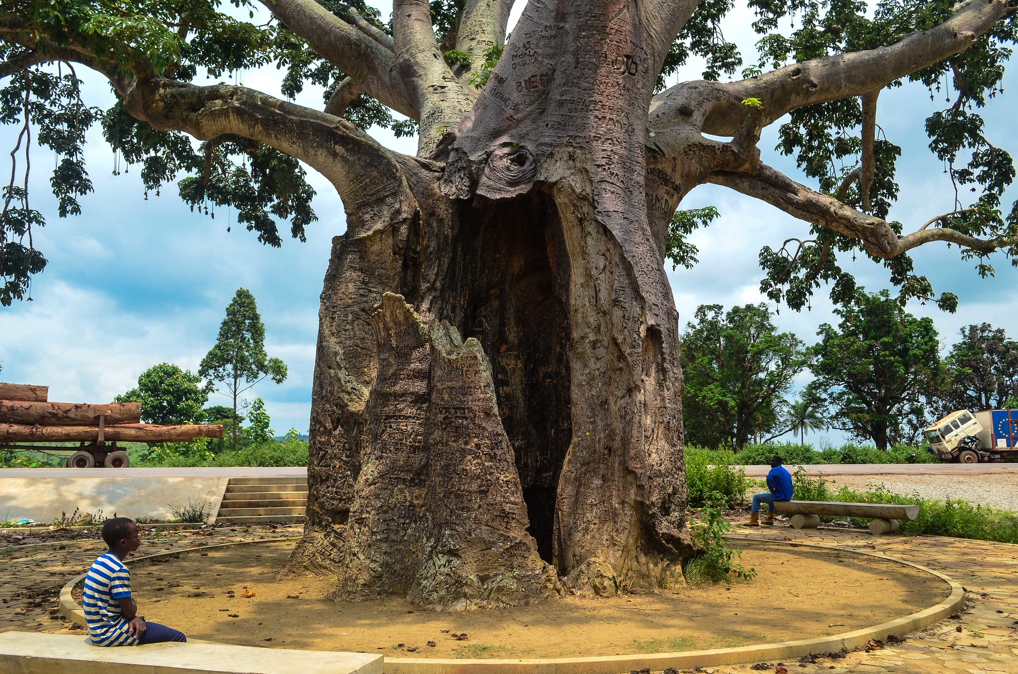
Republic of the Congo, also known as Congo-Brazzaville, is a Central African country characterized by extensive rainforests, protected wildlife areas, Atlantic coastline, and historically significant cities. Much of its territory remains lightly developed, with large national parks safeguarding intact ecosystems that are among the best preserved in the region.
Travel in the Republic of the Congo is shaped by limited infrastructure and the need for careful planning. For experienced travelers, the country offers access to remote forest landscapes, wildlife habitats, and urban centers such as Brazzaville that reflect a blend of colonial history and modern Central African life. It is a destination focused on nature, scale, and authenticity rather than conventional tourism.
Best Cities in Congo Brazzaville
Brazzaville
The Ouaddaï Plains are a wide belt of open savannah and semi-arid grasslands in the far northeast of the Central African Republic, where daily life is shaped by pasture, water points, and seasonal movement rather than fixed “sights”. The landscape is typically flat to gently rolling, with long horizons, sparse tree cover in many areas, and greener river lines or low-lying depressions during the wet season. The most interesting things to see are real working scenes: herds moving between grazing areas, temporary camps, small market gatherings, and the practical crafts and routines that support pastoral households. Because rainfall is strongly seasonal, the contrast between dry months and the rains is dramatic, and travel conditions, wildlife visibility, and the location of camps can change quickly from one period to the next.
Reaching the area is usually expedition-style. Most routes start from Bangui and head northeast to Ndélé, a key hub for the region; the road distance is commonly quoted at about 684 km, often around 18 hours in good conditions, and longer when roads deteriorate. From Ndélé, travelers often continue toward Birao and surrounding zones, with distances that range from roughly 313 km as-the-crow-flies to about 450–460 km by road depending on the track used, so you should plan on multiple days, not a simple day trip. There is an airstrip serving Birao, which can reduce travel time if flights are available, but services are not reliably regular, so most visits still require a 4×4, extra fuel, and local guides who can coordinate access, water, and security-sensitive routing.
Pointe-Noire
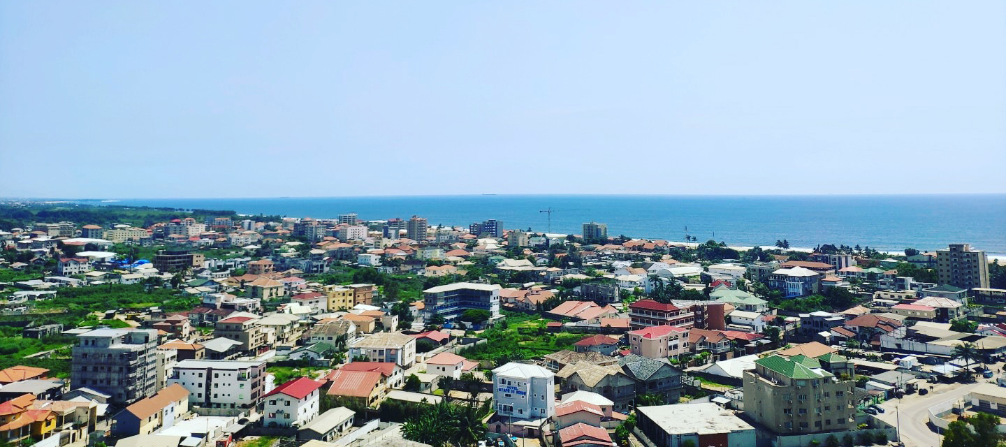
Pointe-Noire is the Republic of the Congo’s main coastal city and its primary economic engine, driven largely by the deep-water port and the offshore oil industry. As the country’s key maritime gateway, the port area and industrial shoreline help you understand how cargo, fuel, and imported goods circulate along the Atlantic coast, while the city itself offers a straightforward beach-and-city mix. For easy coastal time, head to the long Atlantic sands of Côte Sauvage and nearby public beaches, then add a short outing to Pointe-Indienne for a wilder shoreline feel and strong sunset views. If you want something beyond the seafront, the Diosso Gorges are a classic half-day trip, roughly 25 to 30 km north of the city, with red sandstone ravines and viewpoints that contrast sharply with the flat coastal strip.
Pointe-Noire also works well as a base for conservation-focused day trips and multi-day excursions. The Tchimpounga Chimpanzee Rehabilitation Center is commonly visited on a guided basis and sits within easy reach of the city, typically around 30 km depending on your route. For a bigger wilderness commitment, Conkouati-Douli National Park lies farther up the coast (often reached via multi-hour driving, roughly 140 to 170 km to the park zone depending on entry point), combining lagoons, mangroves, forest, and beaches, and it is one of the best options in the country for remote nature landscapes. Getting to Pointe-Noire is simple from the main cities: flights from Brazzaville are usually around 1 hour, while the Congo–Ocean Railway links Brazzaville to Pointe-Noire over roughly 510 km and is often an overnight journey; the road route between the two cities is in the same distance range but can take most of a day depending on conditions. The city is also served by Agostinho-Neto International Airport (PNR), which is the most convenient entry point if you are arriving from outside the country.
Dolisie
Dolisie is a southern regional city in the Republic of the Congo and the administrative center of Niari Department, long known as a transport and trading junction for the Niari Valley. It sits on the Congo–Ocean Railway corridor that links Brazzaville to Pointe-Noire, so the city’s character is shaped by movement: trains, freight, and overland traffic servicing agriculture, timber, and everyday commerce from surrounding forest and savannah zones. For visitors, the most worthwhile “things to do” are practical and local: spend time around the market and the railway area to see how goods circulate, then take a short drive outside town to rural landscapes that transition quickly into more heavily forested inland areas. Dolisie is also a logical staging point if you want to continue deeper south and southwest toward smaller towns and forest communities where services become thinner.
Getting there is straightforward by rail, road, or air. From Pointe-Noire, the road distance is roughly 160 to 170 km, commonly several hours by car depending on conditions; by train on the Congo–Ocean line, Dolisie is a major intermediate stop, and travel time is often around 6 hours, with schedules that can be limited. From Brazzaville, you can also use the same railway line for a longer ride, or drive via the main southbound routes; distances are typically around 400 km plus by road, with travel times that can take most of a day. If you need an aviation option, Dolisie is served by Ngot Nzoungou Airport (DIS), which has an asphalt runway of about 2,050 m and is useful for charter or irregular services when available.
Ouesso
Ouesso is a northern river town in the Republic of the Congo, serving as the administrative capital of Sangha Department and a practical access point to the Congo Basin rainforest near the Central African Republic border. Set on the Sangha River, it is best experienced through its working riverfront: canoe and boat landings, small fish trade, and the steady movement of supplies that link forest settlements to a regional hub. The town itself is low-key rather than “touristic”, but it is valuable for context. A walk through the main market and the riverbank areas gives a clear sense of how a remote rainforest economy functions, from basic goods and food staples to transport and logistics. Staying an extra night often pays off simply because departures to forest zones, and river travel windows, tend to be early and schedule-dependent.
Ouesso is also used as a jumping-off point for northern rainforest expeditions, including routes toward the Nouabalé-Ndoki area (typically continuing to Bomassa by vehicle and/or river, depending on the itinerary and season). Reaching Ouesso is most straightforward by air: Ouesso Airport (OUE) has an asphalt runway of about 3,000 m, which supports reliable aircraft operations when flights are available.
Best Natural Wonders Sites
Odzala-Kokoua National Park
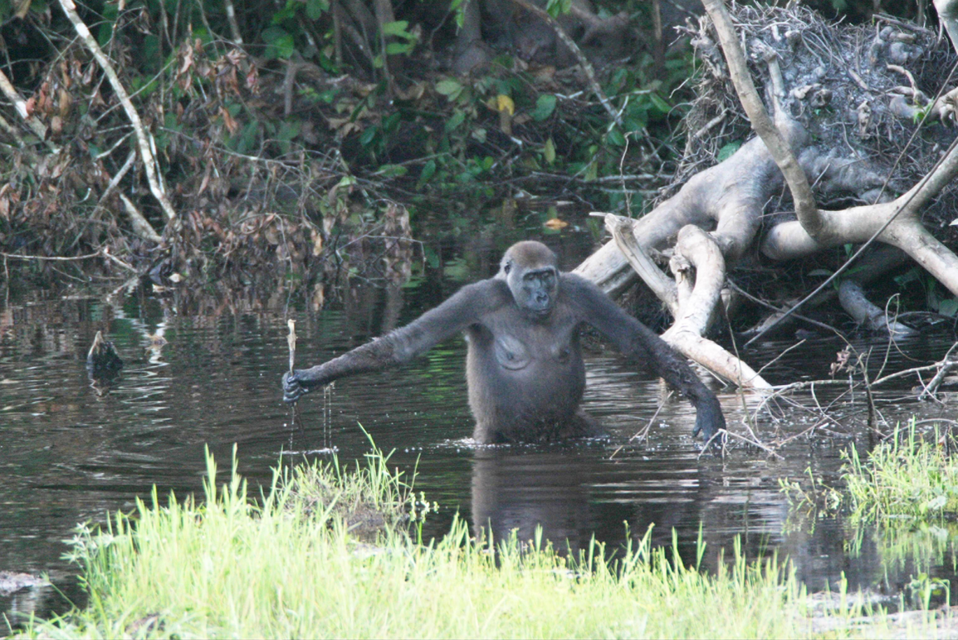
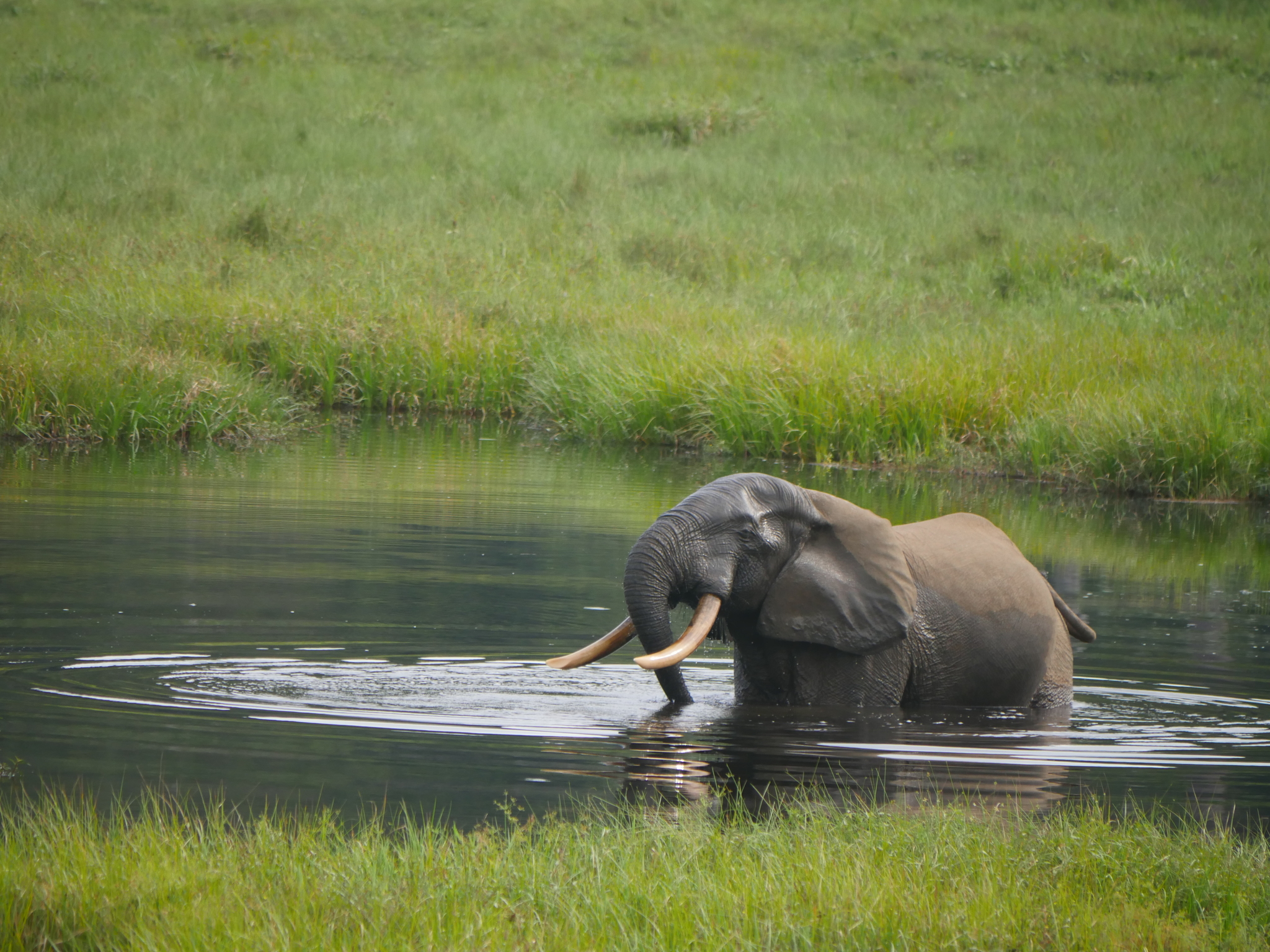
Odzala-Kokoua National Park is one of Central Africa’s flagship lowland rainforest reserves and a standout destination in the Republic of the Congo for high-quality, guided wildlife experiences. The park protects a vast block of Congo Basin forest, swamp and river habitats, and natural clearings known as bais, where animals come to feed on minerals and fresh vegetation. That is why the park is famous for forest elephants and western lowland gorillas, but it also supports forest buffalo, sitatunga, and a strong lineup of primates, with sightings often concentrated around bais and along river edges. The typical visitor experience is not self-drive: it is lodge-based and guided, combining long forest walks, bai observation from platforms, and tracking sessions where rules on group size, distance, and time are enforced to reduce disturbance and disease risk.
Access is deliberately controlled and usually routed through a lodge operator, which is why planning matters more here than elsewhere. Many itineraries start with a flight into Brazzaville, then continue either by a domestic connection and road transfer, or by a long overland drive that can take a full day or more depending on the route and season. The most common approach is to treat the park as a fixed, multi-day stay rather than a quick stop: allow enough time for several tracking attempts because rainforest wildlife is less predictable than on open savannah.
Mbeli Bai
Mbeli Bai is a famous rainforest clearing, but it is not inside Odzala-Kokoua. It is in Nouabalé-Ndoki National Park in northern Republic of the Congo, and it is protected as a small, highly monitored site of about 12.9 hectares. What makes it exceptional is visibility: in dense lowland forest you normally hear wildlife more than you see it, yet at Mbeli Bai animals regularly step out into an open, marshy clearing where you can watch them for hours from a raised observation platform (about 5 m high). Forest elephants are the headline species, but western lowland gorillas also visit, along with sitatunga, multiple monkey species, and a strong mix of forest birds. The “best” experience is not a quick stop. It is sustained, quiet watching, where the real payoff is behavior: elephants interacting at the edge of the marsh, gorillas feeding and moving through the clearing, and the constant traffic of smaller species around water and mineral-rich soils.
Access is strictly managed and typically arranged through park-approved logistics. The usual base is Bomassa (park headquarters area): from Bomassa, reaching the viewing platform commonly involves roughly a 45-minute drive, then travel by dugout canoe up the Ndoki and Mbeli rivers, followed by about a 45-minute forest walk to the platform. To get to Bomassa, most travelers first reach Ouesso, which is about 2 hours away by boat on the Sangha River or around 3 hours by car, depending on conditions and the chosen route. From the main national gateway city, Brazzaville, you either fly domestically to Ouesso or commit to a long overland journey that is often described as around 12 hours in good conditions, then continue by boat or vehicle to Bomassa before the final staged approach to Mbeli Bai.
Nouabalé-Ndoki National Park
Nouabalé-Ndoki National Park is a remote, largely intact block of Congo Basin lowland rainforest in northern Republic of the Congo, created in 1993 and covering roughly 3,900 to 4,300 km² depending on the boundary reference used. It forms part of the Sangha Trinational UNESCO World Heritage landscape (inscribed in 2012), a cross-border conservation complex of about 7,463 km² that links Congo, Cameroon, and the Central African Republic. Biodiversity is exceptional: recent survey summaries commonly cite around 116 mammal species, roughly 429 bird species, and more than 1,100 plant species. The park is particularly known for forest elephants and great apes, including western lowland gorillas and chimpanzees, plus rarer forest specialists such as bongo and sitatunga. What visitors come for is not “drive-and-spot” safaris but guided rainforest immersion: quiet observation at forest clearings and river edges where animals concentrate, and strictly managed tracking on foot that emphasizes low impact and safety protocols.
Lac Télé Community Reserve
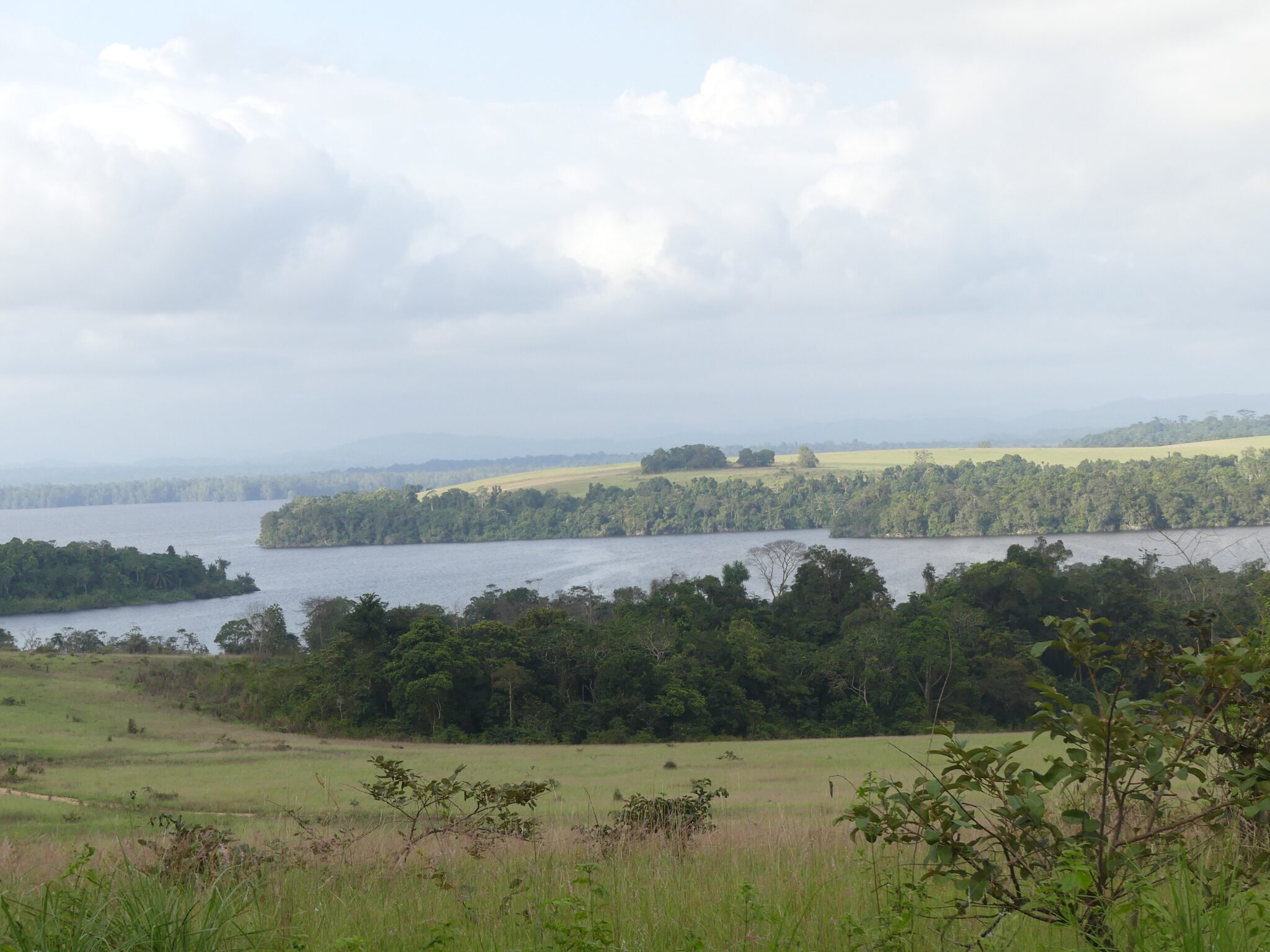
Lac Télé Community Reserve is a community-managed protected landscape in the far north of the Republic of the Congo, combining swamp forest, seasonally flooded forest, floating meadows, and slow, blackwater channels. Established in 2001 and covering roughly 4,400 to 4,500 km², it sits within the wider Congo Basin peatland region, where peat deposits are linked to very large carbon storage at a continental scale. The reserve is especially valued for biodiversity that thrives in wet forests: strong birdlife (waterbirds and forest specialists), primates, and a range of forest mammals that are notoriously difficult to observe elsewhere because the habitat is dense and access is limited. What you “do” here is immersive nature travel rather than classic sightseeing: canoe travel through flooded forest corridors, quiet hours listening and scanning for birds and monkeys, and visits to fishing communities where smoked fish, nets, dugout canoes, and river-season knowledge define daily life.
Getting in is the main challenge and also part of the appeal. The usual gateway is Impfondo, the regional capital, reached most realistically by domestic flight from Brazzaville in roughly 1 hour 15 minutes to 1 hour 30 minutes, or by long riverboat journeys that can take about a week depending on the boat and stops.
Conkouati-Douli National Park
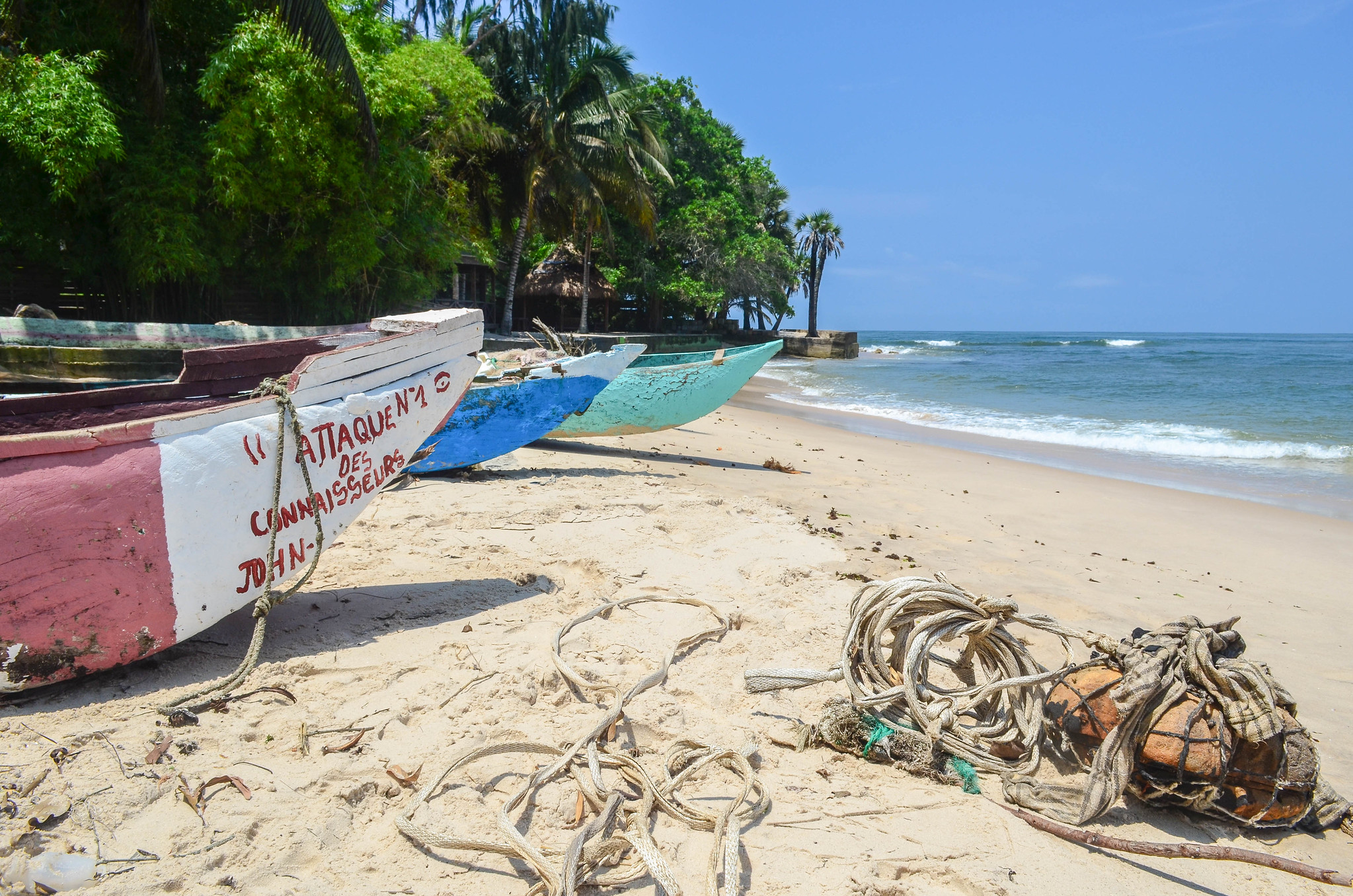
Conkouati-Douli National Park is the Republic of the Congo’s flagship coastal protected area near the Gabon border, created in 1999 and known for an unusually rich mix of habitats in one place. The park combines Atlantic beaches, lagoons, mangroves, swamp forest, lowland rainforest, and patches of savannah, with a protected footprint often described at roughly 8,000 km² when the marine zone is included (around 4,100 km² marine and about 3,800 km² on land). This habitat mosaic supports forest elephants, chimpanzees, western lowland gorillas, and forest buffalo inland, while the coastline is a major asset for marine life: several species of sea turtles nest on the beaches, and the offshore waters are used seasonally by whales and dolphins. The best experiences are guided and place-based, such as tracking in forest blocks, slow exploration of lagoon and mangrove systems by boat, and beach walks focused on nesting signs and coastal ecology rather than “typical” sightseeing.
Most visits are organized from Pointe-Noire, the nearest major city and airport hub. The park’s northern access points are commonly described as about 100 km from Pointe-Noire, but reaching the more remote sections closer to the Gabon border can push the driving distance to roughly 150–170 km depending on where you enter and what you want to see, with travel times ranging from about 2 hours to much longer when tracks are sandy, muddy, or degraded. Overland routes generally follow the coastal corridor toward Nzambi and the districts of Madingo-Kayes and Nzambi, then continue on smaller roads and tracks, so a 4×4 is the realistic baseline if you want flexibility.
Pointe Indienne
Pointe Indienne is a quieter stretch of Atlantic coast north of Pointe-Noire, valued for its long, open beaches, simple fishing villages, and a generally undeveloped shoreline where you can still get big-sky coastal scenery without city noise. The main things to do are straightforward: beach walks over wide sand flats, watching pirogues come in and out with the day’s catch, and stopping at small roadside stalls for grilled fish when available. The surf can be strong and currents are often unpredictable along this coast, so it is better for walking, photography, and sunset views than for casual swimming unless you have local advice on safe spots and conditions.
From Pointe-Noire, Pointe Indienne is an easy half-day or day trip by road. Depending on the exact beach access point you choose, plan roughly 20 to 35 km from the city center, usually 30 to 60 minutes by car in normal traffic, longer if you continue farther along sandy tracks to more secluded sections. The simplest option is a taxi or hired car for a round trip, while visitors with more time often combine Pointe Indienne with other coastal stops north of town, keeping extra daylight for the return because lighting, signage, and services are limited once you leave the main urban area.
Diosso Gorge
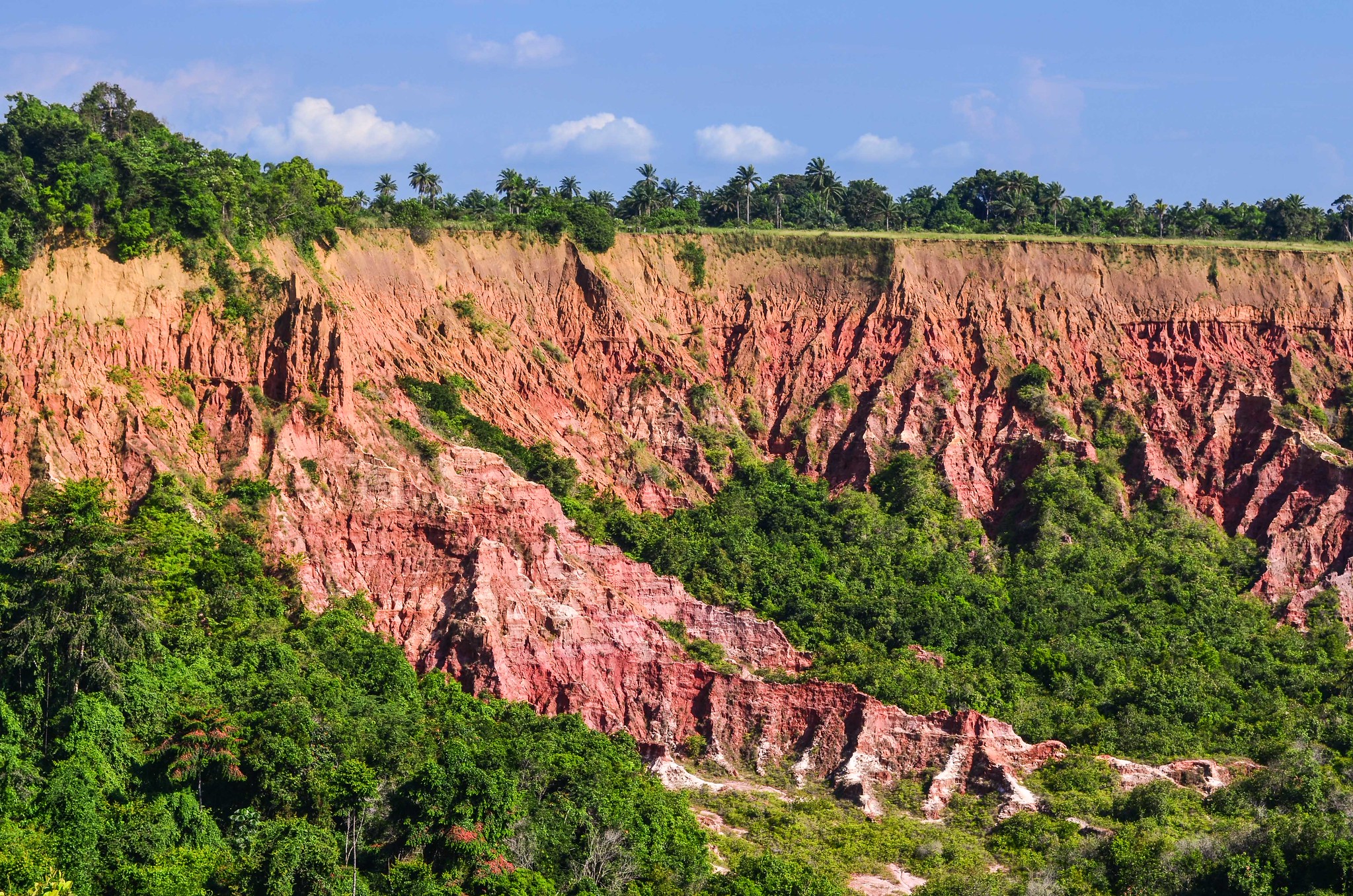
Diosso Gorge is a striking erosional landscape just north of Pointe-Noire, known for its deep ravines cut into soft, iron-rich red and orange sediments that create layered walls, sharp edges, and dramatic natural “amphitheater” views. The main appeal is the contrast: in a short walk you move from relatively flat coastal terrain to steep, sculpted gullies with photogenic viewpoints and changing colors depending on sun angle. Plan to spend 1 to 2 hours on site for viewpoints and short paths along the rim; after rain the ground can be slippery and the edges may be unstable, so staying back from the lip is sensible. Early morning or late afternoon usually gives the best light for photos and clearer relief in the formations. From Pointe-Noire, Diosso Gorge is an easy half-day trip. It is typically around 25 to 30 km from the city, often 30 to 50 minutes by car depending on traffic and the exact approach, with the simplest option being a taxi or hired car with a fixed return time.
Best Cultural and Historical Sites
Basilica of Sainte-Anne (Brazzaville)
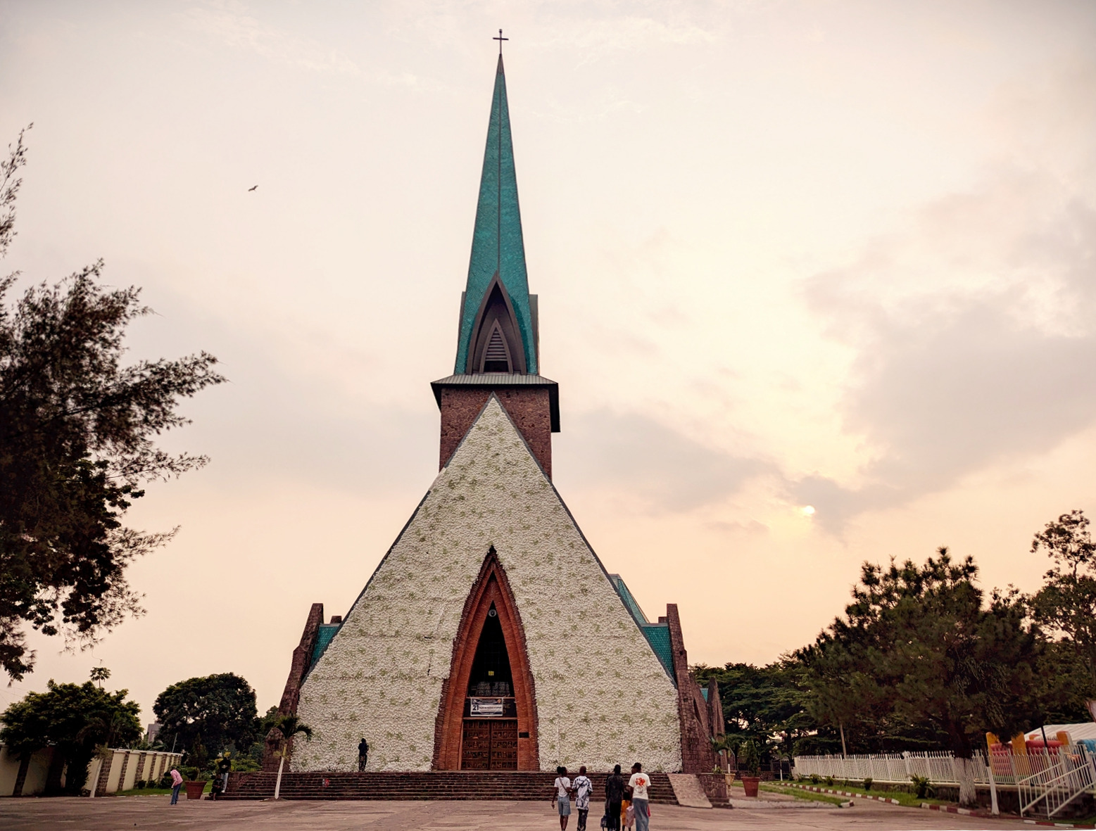
The Basilica of Sainte-Anne in Brazzaville is the city’s most recognizable church landmark, instantly identified by its steep green-tiled roof and a design that blends European modernist and Gothic-inspired forms with Congolese motifs. Construction began in the 1940s under the French architect Roger Erell, with the building commonly associated with 1943 and a dedication in 1949. Architecturally, it is notable for its scale and proportions: the church is often described as about 85 m long, with a transept around 45 m wide and an interior arch height of roughly 22 m. Details worth noticing on site include the pointed-arch rhythm of the structure, the heavy use of brick, and the prominent metalwork on the main entrances, which together make it one of Brazzaville’s most photogenic buildings.
Congo National Museum
The Congo National Museum in Brazzaville is the capital’s most direct introduction to the country’s material culture, with a collection that is often described as exceeding 2,000 objects and rooted in a museum institution founded in 1965. Inside, expect ethnographic displays such as traditional masks, carved figures, household and farming tools, knives and metalwork, ceremonial items, and musical instruments that help you recognize regional styles and materials used across the country. Plan about 1 to 2 hours for a focused visit, longer if you prefer to move slowly and connect the exhibits to what you have seen in markets and craft quarters.
Reaching the museum is straightforward once you are in Brazzaville, as it is in the central urban area and typically a short taxi ride from the Plateau and nearby districts, often around 10 to 20 minutes depending on traffic. From Maya-Maya Airport, allow roughly 20 to 40 minutes by car under normal conditions. If you are coming from Pointe-Noire, the fastest option is usually a domestic flight to Brazzaville (often around 1 hour in the air), while the rail journey on the Congo–Ocean line is a longer, schedule-dependent alternative; from either arrival point, a taxi to the museum is a simple final leg.
Diosso Royal Palace
Diosso Royal Palace is the former residence associated with the rulers of the Loango Kingdom, the historic coastal state that shaped trade and politics along this part of the Atlantic between roughly the 16th and 19th centuries. The building is best understood today as a heritage site and museum space, linked in particular to King Ma Moe Loango Poaty III, who reigned from 1931 to 1975 and lived here during the late colonial and early post-independence era. The structure itself is modest in scale, commonly described at about 20 m long and 11 m wide, with former living rooms, corridors, bedrooms, and private spaces repurposed into small exhibition rooms. Expect collections focused on pre-colonial coastal kingdoms and local Vili culture, with practical objects such as work tools, household items, ceremonial pieces, masks, and musical instruments, typically presented as a compact set of several hundred exhibits rather than a large, modern gallery.
It is an easy half-day trip from Pointe-Noire: Diosso lies about 25 km north of the city on the main coastal road, and the drive is usually around 30 to 50 minutes depending on traffic and the last few kilometres of access. Many visitors combine the palace with Diosso Gorge on the same outing since they are in the same area, which makes the trip feel fuller without adding much extra distance. From Dolisie, the most practical approach is to travel first to Pointe-Noire (roughly 160 to 170 km by road, commonly several hours), then continue north to Diosso. From Brazzaville, you typically reach Pointe-Noire by a domestic flight (about 1 hour in the air) or by the Congo–Ocean Railway, then complete the final leg by car or taxi.
Pierre Savorgnan de Brazza Memorial
The Pierre Savorgnan de Brazza Memorial is a prominent marble-and-glass mausoleum in central Brazzaville, built in 2006 and widely reported to have cost around US$10 million. It commemorates Pierre Savorgnan de Brazza, the Franco-Italian explorer associated with the city’s founding in October 1880, and the memorial complex houses the reinterred remains of Brazza and close family members. Beyond the tomb space, the site is designed as a modern civic landmark: a museum-style interior presents historical context through photos and curated objects, and the exterior includes formal landscaping and a large statue set on a tall base, making it one of the capital’s most photographed monuments and a useful stop for understanding how Brazzaville narrates its own origins. Getting there is easy from anywhere in central Brazzaville by taxi, typically 10 to 20 minutes depending on traffic. From Maya-Maya International Airport, it is a short urban transfer of roughly 3 km, often about 10 to 15 minutes by car.
Hidden Gems of the Congo Brazzaville
Bomassa
Bomassa is a small, functional settlement in northern Republic of the Congo that acts as the main staging point for Nouabalé-Ndoki National Park. It is not a destination for “city sights”, but a logistics base where permits, guides, boats, and vehicles are organized before heading into deep lowland rainforest. The practical things to see are the river-and-forest edge routines: supply boats arriving, equipment being loaded, and the way a remote conservation landscape is serviced day to day. Because tourism is intentionally limited, accommodation is usually simple and tied to expedition operators or research and conservation activity rather than mainstream hotels.
Most travelers reach Bomassa via Ouesso, the nearest major town on the Sangha River. From Ouesso, the transfer to Bomassa is typically done either by road in roughly 2.5 to 3.5 hours or by riverboat in around 1.5 to 2.5 hours, depending on water level and the chosen route. From Brazzaville, the most realistic approach is a domestic flight to Ouesso, then the onward transfer; overland travel from the capital to this region is very long and rarely the practical choice unless you are on a multi-day, fully supported journey.
Impfondo
Impfondo is a remote river town in the far north of the Republic of the Congo and the administrative capital of Likouala, a department covering about 66,044 km². The town sits on the Oubangui River and functions as a practical staging point for the region’s swamp forests and wetland landscapes, where travel is defined by waterways, pirogues, and seasonal flooding rather than roads. Population figures from recent census reporting put the town itself at about 38,000 residents, while the wider administrative area is often listed at roughly 55,000, which gives an idea of how sparsely populated the surrounding forests are. On the ground, the main “things to do” are simple but distinctive: spend time on the riverfront to see fish landings, canoe traffic, and supply movements, then use the town as a launch point for guided trips toward community-based forest areas such as Lac Télé. The draw is not monuments but intact wetland ecology, traditional fishing life, and multi-day travel through blackwater channels where birdlife and primates are often the most visible wildlife.
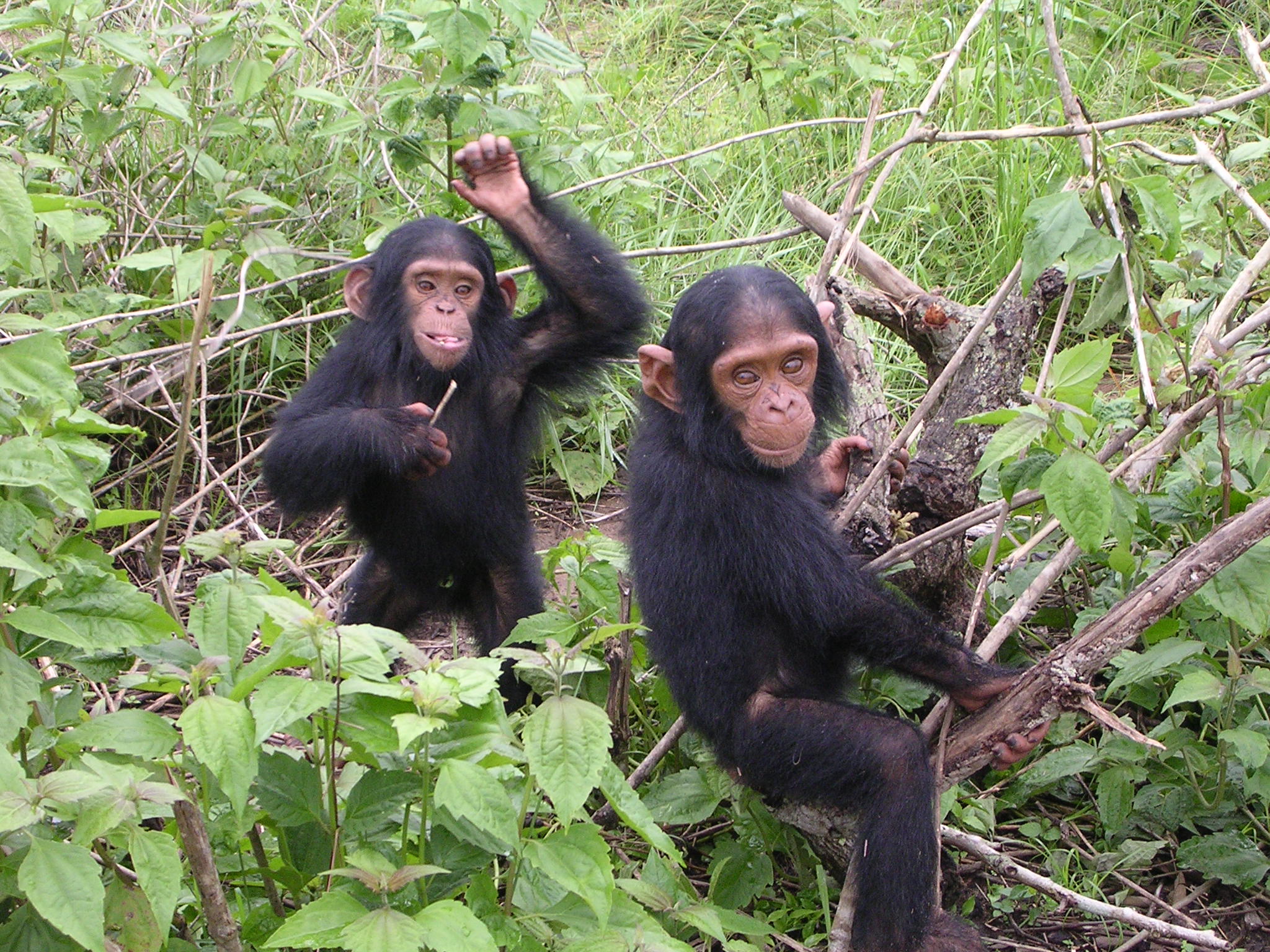
Tchimpounga Chimpanzee Rehabilitation Center
Tchimpounga Chimpanzee Rehabilitation Center (often called Tchimpounga Sanctuary) is one of the Republic of the Congo’s most accessible, high-impact conservation visits. Founded in 1992 and run with the Jane Goodall Institute and national authorities, it focuses on rescuing and rehabilitating chimpanzees confiscated from illegal pet trafficking and the bushmeat trade. The site lies on a coastal plain of forest and savannah and is frequently described as covering about 70 km², with facilities designed to keep human contact controlled while allowing visitors to learn about chimpanzee behavior, threats, and rehabilitation work. In practical terms, it is a rare place where you can see conservation in action: the sanctuary has cared for more than 200 chimpanzees over time, and it commonly houses well over 100 individuals at any given period, often reported around the 150 range.
Most visitors go from Pointe-Noire, because the sanctuary is about 50 km north of the city. In normal conditions, plan roughly 1 to 1.5 hours each way by road using a hired car or taxi with a fixed return time; guided visits are the norm, and timing can depend on staff availability and the day’s care routines. If you are coming from Dolisie, the simplest approach is Dolisie to Pointe-Noire first (roughly 160 to 170 km), then continue north to Tchimpounga, which usually makes it a full-day outing with early departure. From Brazzaville, the most efficient route is typically a flight to Pointe-Noire (around 1 hour in the air), followed by the same road transfer, while rail is a slower alternative if you are already planning the Congo–Ocean line.
Kayo Island
Kayo Island is a small offshore islet near Pointe-Noire that remains largely outside standard tourist itineraries, which is part of its appeal. Expect a simple, natural coastal experience rather than built attractions: sandy sections suitable for long beach walks, low coastal vegetation adapted to salt spray, and a “working coast” atmosphere shaped by nearby fishing activity. Conditions on this stretch of the Atlantic are often defined by swell and strong currents, so it is best approached for scenery, photography, and a quiet escape from the city rather than for casual swimming unless you have clear, local guidance on safe spots and tides.
Travel Tips for the Republic of the Congo
Safety and General Advice
Travel conditions in the Republic of the Congo vary greatly by region. The major cities of Brazzaville and Pointe-Noire are generally calm and welcoming, while remote forest regions require advance planning and reliable local contacts. Travelers should stay updated on current travel advisories and always seek local guidance when venturing beyond urban centers. Organized travel with experienced operators is strongly recommended for those exploring national parks or interior provinces.
Health and Vaccinations
A yellow fever vaccination is required for entry, and malaria prophylaxis is strongly recommended. Medical facilities outside Brazzaville and Pointe-Noire are limited, so visitors should carry a well-stocked first-aid kit and comprehensive travel insurance with evacuation coverage. Tap water is not safe to drink; bottled or filtered water should be used at all times. Travelers should also pack mosquito repellent, sunscreen, and any necessary prescription medication, as pharmacies can have limited supplies in rural areas.
Transportation and Getting Around
International flights arrive mainly in Brazzaville and Pointe-Noire, the country’s two principal entry points. Domestic flights are limited and often irregular, so schedules should be checked in advance. Overland travel can be slow and challenging due to forest terrain, heavy rains, and uneven road conditions, especially outside the main urban corridors. River transport on the Congo and its tributaries remains an important and scenic way to reach remote communities and trading centers.
Car Rental and Driving
An International Driving Permit is required in addition to your national driver’s license, and all documents should be carried at checkpoints, which are common along major routes. Driving in the Republic of the Congo is on the right-hand side of the road. Roads within Brazzaville and Pointe-Noire are generally paved, but many rural routes are unpaved or affected by weather, particularly during the rainy season. A 4×4 vehicle is essential for reaching national parks or remote villages. Because of variable road conditions and frequent checkpoints, hiring a driver is often safer and more practical than self-driving.
Published January 23, 2026 • 22m to read