Namibia is one of Africa’s most visually striking destinations, defined by wide desert landscapes, a cold Atlantic coastline, and well-managed wildlife areas. It is particularly well suited to self-drive travel, as long distances, low traffic, and open roads are part of the experience rather than an obstacle. Travel here emphasizes space, light, and gradual changes in scenery rather than dense sightseeing.
A well-designed Namibia itinerary focuses on pacing and timing. Many of the country’s key locations, such as desert dunes, salt pans, and coastal landscapes, are best experienced early in the morning or late in the afternoon, when light and temperatures are more favorable. Instead of rushing between multiple regions, spending more time in fewer places allows travelers to fully appreciate the scale, silence, and atmosphere that make Namibia distinctive.
Best Cities in Namibia
Windhoek
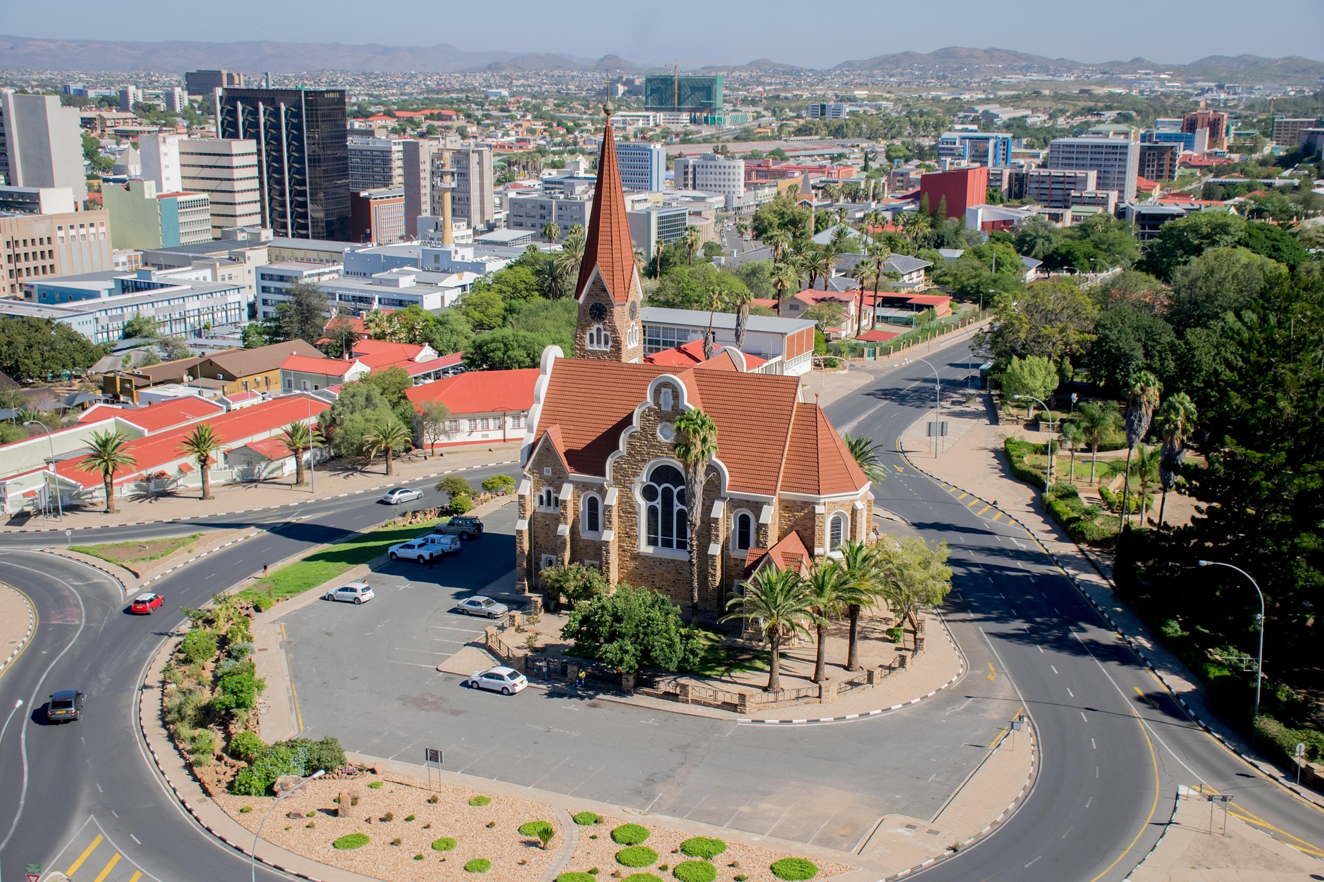
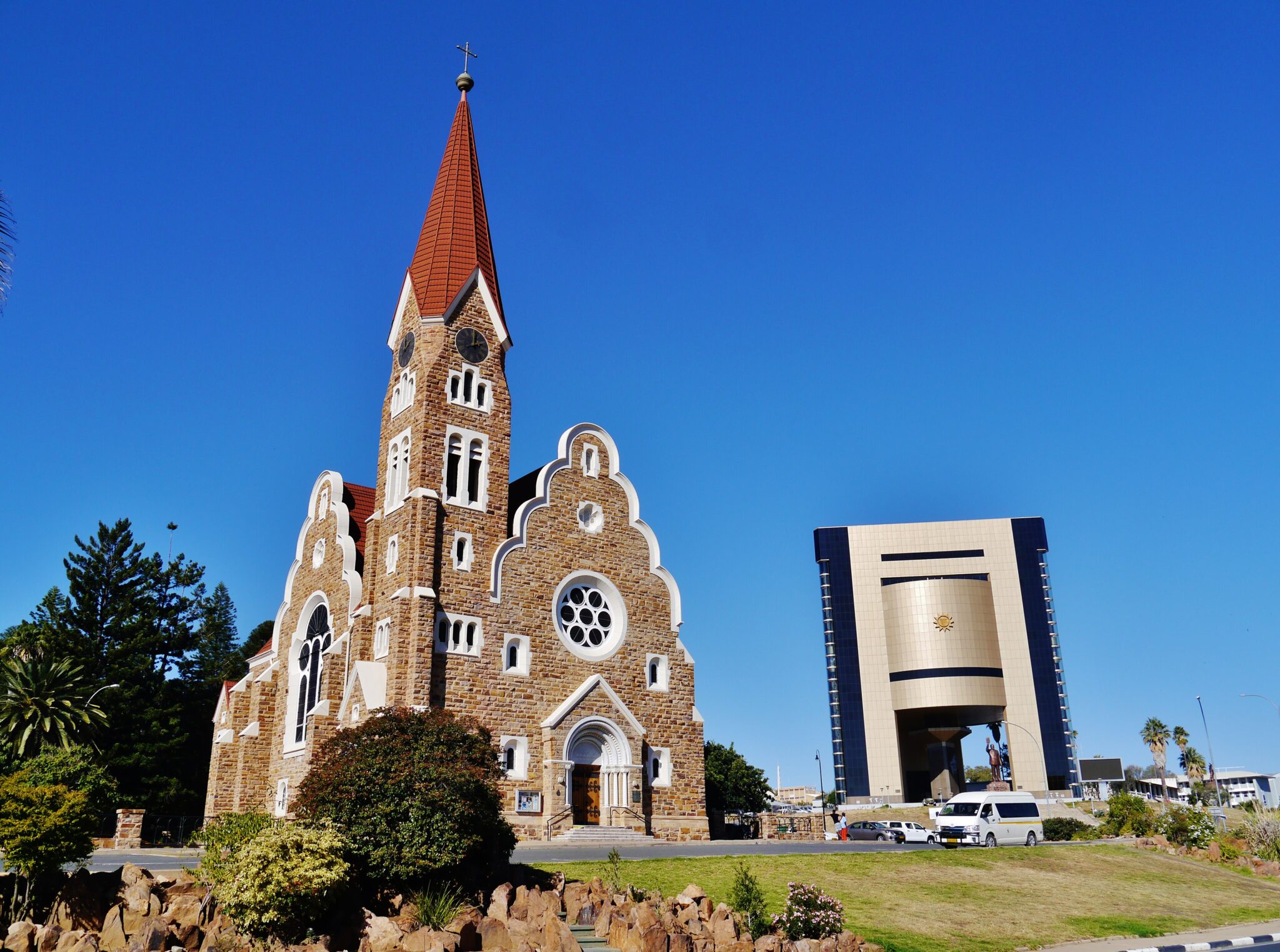
Windhoek is Namibia’s compact, practical capital and the country’s main arrival and setup point, set on a high plateau at about 1,655 m above sea level. The city counted 486,169 residents in the 2023 census and covers roughly 5,133 km², which helps explain why it feels spacious and easy to navigate compared with many African capitals. Use it for high-value, low-time stops: the Independence Memorial Museum (opened 20 March 2014) is the most useful cultural anchor for modern history, while the Namibia Craft Centre and nearby craft stalls are strong for quality textiles, baskets, carvings, and small gifts without needing to bargain for hours. If you want an easy “city rhythm” afternoon, combine a craft stop with a café or dinner in central districts, then keep the rest of your time focused on preparation rather than chasing sights.
For logistics, Windhoek is where Namibia becomes simple: vehicle pickup, supplies, and route checks. Hosea Kutako International Airport (WDH) sits about 45 km east of the city (often 45 to 60 minutes by road), while Eros Airport is about 5 km from the CBD, useful for domestic and scenic flights. As a driving base, typical benchmark legs are Windhoek to Swakopmund about 360 km (around 4 to 5 hours), Windhoek to Sesriem about 345 to 350 km (commonly 5 to 7 hours depending on road type and stops), and Windhoek to Etosha’s Anderson Gate about 415 km (around 4 to 5 hours).
Swakopmund
Swakopmund is Namibia’s classic Atlantic coast base, founded in 1892 and still defined by its German-era townscape, seafront promenade, and a cool, fog-prone coastal climate that feels very different from the interior. The best way to experience it is by mixing short, walkable city stops with a half-day in the dunes. In town, highlights include the Swakopmund Jetty (a photogenic pier and viewpoint), the Swakopmund Museum for coastal and desert history, and small heritage streets where colonial-era façades sit next to cafés and bakeries. It is also one of Namibia’s top “activity hubs”, with reliable operators for sandboarding, quad biking, fat-biking in the dunes, and skydiving, making it an easy place to add adrenaline without complex logistics.
Swakopmund is very well positioned for day trips. It is about 35 km from Walvis Bay (typically 30–40 minutes by road), which is the main regional transport node and a common starting point for boat cruises and lagoon scenery. From Windhoek, the drive is roughly 360 km on the B2, usually 4–5 hours in normal conditions, which is why many self-drive itineraries use Swakopmund as a “rest and resupply” stop after long desert legs. Popular excursions include the dune corridor toward Walvis Bay and the coastal dunes beyond, plus inland desert scenery such as the Moon Landscape and Welwitschia areas, which are often done as a half-day outing with a guide.
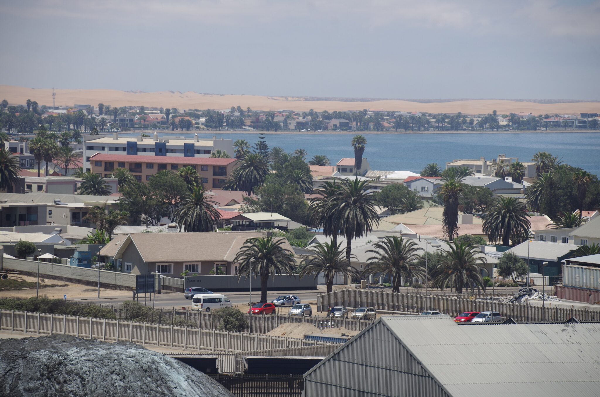
Walvis Bay
Walvis Bay is Namibia’s main Atlantic port and the most “waterfront-focused” stop on this coast, built around a working harbor and a sheltered lagoon that is one of the country’s best places for easy birdwatching. The lagoon is shallow and protected, so it regularly attracts large flocks of flamingos and other waterbirds, and the scenery is at its best when the light is soft and the wind is low, typically early morning. For travelers, the most rewarding activities are simple and practical: a lagoon-front walk for birds and views, and a boat-based outing from the harbor, where marine cruises often look for dolphins, Cape fur seals, and pelagic birdlife in the bay.
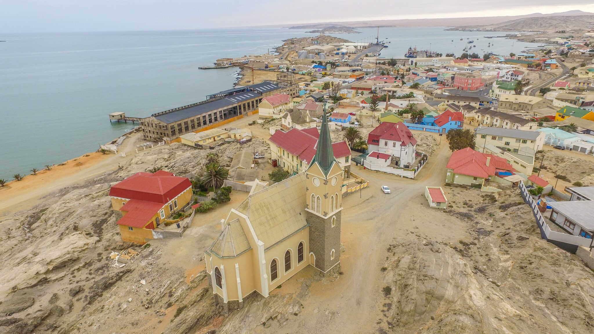
Lüderitz
Lüderitz is a small Atlantic town in southern Namibia with a strong “edge of the map” feel, shaped by wind, cold Benguela Current air, and a history tied to the early diamond era. It is famous for its compact collection of German-era architecture, especially the brightly painted Art Nouveau and Wilhelmine-style buildings that stand out against the desert coastline. The most rewarding town stops are short and atmospheric: a walk around the historic core for landmarks such as Felsenkirche (1912) and Goerke Haus (1909–1911), then down to the waterfront and Shark Island for sea views and the full sense of isolation. Lüderitz is also the natural base for Kolmanskop, the abandoned diamond-mining settlement about 10 km east of town, where you can see sand-filled rooms and the remains of an early-1900s boomtown in a single, highly photogenic visit.
Getting to Lüderitz is part of the experience. By road, most travelers approach via Aus, which is about 120 km away on the B4 (typically 1.5–2 hours), while Keetmanshoop is roughly 300 km (often 3.5–5 hours depending on stops and road conditions). From Windhoek, plan approximately 700 km and a long full-day drive (commonly 8–10+ hours with breaks), which is why many itineraries break the journey overnight around Keetmanshoop or Aus.
Best Natural Wonders Sites
Etosha National Park
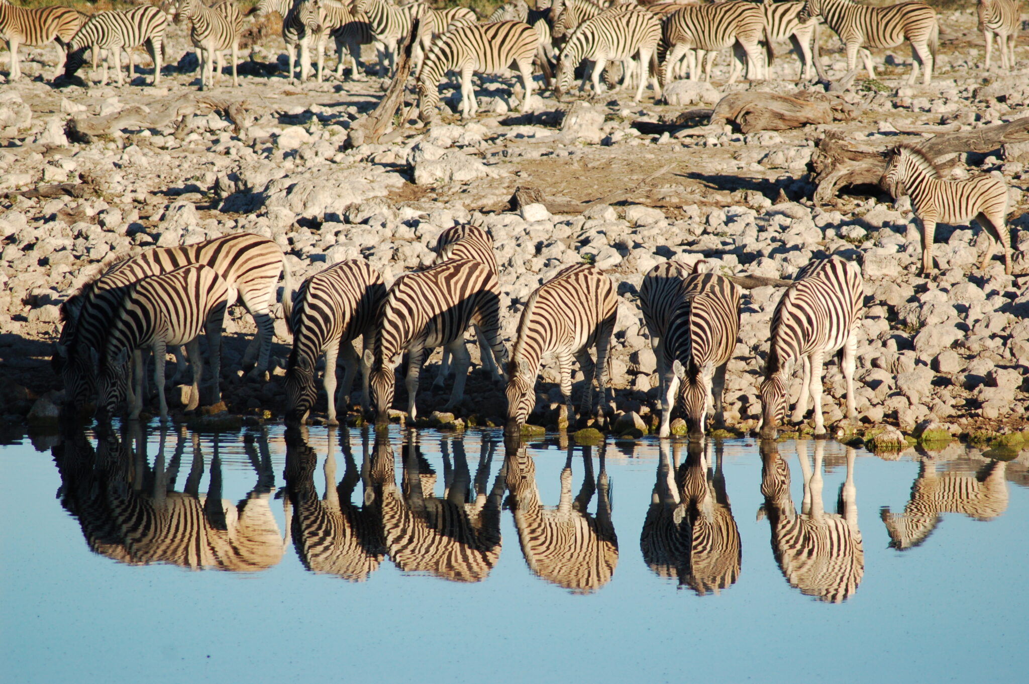
Etosha National Park is Namibia’s flagship safari area, covering about 22,270 km² and built around the Etosha Pan, a vast salt-and-clay depression of roughly 4,760 km² that turns into a shallow seasonal lake after heavy rains and becomes a bright, mineral-white expanse in the dry months. The park is famous for waterhole-based viewing because in the dry season (typically May to October) wildlife concentrates around permanent water points, making sightings feel structured and repeatable even on self-drive routes. Expect strong numbers of plains game such as zebra, springbok, wildebeest, and oryx, plus predators including lion and spotted hyena; Etosha is also one of southern Africa’s better places for black rhino viewing, with some of the most consistent chances often coming at floodlit camp waterholes after dark. The landscapes are part of the appeal: long, open sightlines, heat shimmer over the pan, and dust-and-acacia scenery that looks starkly different from classic riverine safari parks.
Etosha is very straightforward to integrate into a Namibia self-drive itinerary. From Windhoek to Anderson Gate (Okaukuejo area) is commonly around 410–420 km and usually 4 to 5 hours by road; Windhoek to Von Lindequist Gate (Namutoni area) is typically 530–560 km and often 6 to 7 hours, depending on your route and stops. From Swakopmund, the drive to the western/central Etosha zone is usually about 490–520 km (often 6 to 7 hours). Once inside, the most productive rhythm is slow: choose a small set of waterholes, stay 30–90 minutes at each, and let animals come to you rather than driving constantly.
Namib-Naukluft National Park
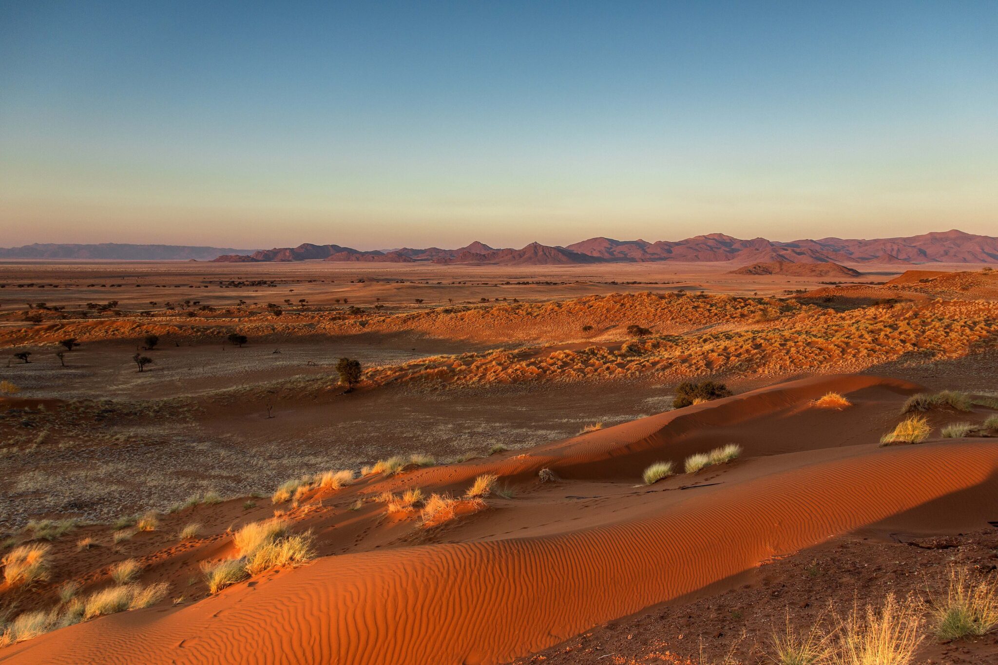
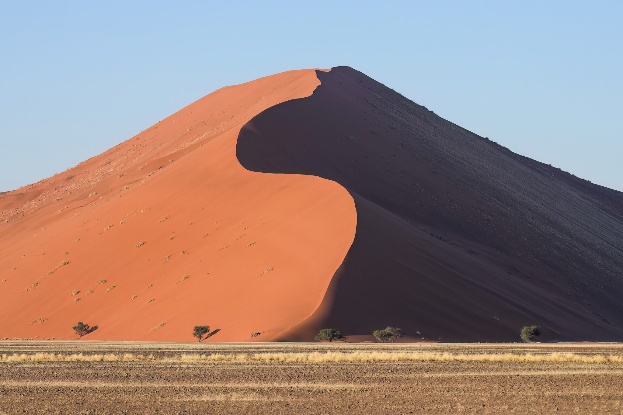
Namib-Naukluft National Park is Namibia’s classic “red-dune” landscape and one of the largest protected desert areas in Africa, covering roughly 49,800 km². Its most iconic zone is the dune sea around Sossusvlei and Deadvlei, where towering dunes back onto pale clay pans and blackened camelthorn skeletons that can be several hundred years old. Popular sunrise targets include Dune 45 (a shorter, well-known climb close to the main road) and Big Daddy, often cited at around 325 m high, which overlooks Deadvlei for one of the most photographed desert views in the country. Beyond the dunes, the park’s scale shows in gravel plains, rugged mountain backdrops, and long, empty horizons that make even simple drives feel cinematic, especially in the first two hours after sunrise and the last two hours before sunset.
Most travelers access the flagship dune area via Sesriem, the main gateway. From Windhoek to Sesriem is typically 345–350 km (commonly 5–7 hours depending on road type and stops). From Swakopmund/Walvis Bay, distances are usually 300–370 km, often 5–7 hours, again depending on whether you route via inland gravel roads or the main corridors. From Lüderitz, Sesriem is commonly about 300–350 km (often 4.5–6.5 hours). For Sossusvlei itself, plan on an early start because the heat rises fast and the best light is short-lived; the final approach involves a sandy section where many travelers use a 4×4 or a shuttle if they are not driving a capable vehicle.
Skeleton Coast National Park
Skeleton Coast National Park is Namibia’s most atmospheric stretch of coastline, a foggy, wind-scoured meeting point of Atlantic Ocean and desert that feels defined by emptiness rather than “sights”. The park covers about 16,845 km² and runs for roughly 500 km from the Ugab River in the south to the Kunene River in the north, usually 30 to 40 km wide inland, which explains why it feels like a long, narrow ribbon of harsh terrain. Established in 1971, it is famous for shipwreck lore, cold Benguela Current fog, and desert-adapted wildlife that survives around river mouths and coastal corridors. The best experience is the mood: big skies, shifting fog, dunes pushing toward the sea, and long gravel-road horizons where stopping for a few minutes can feel like you have the coast to yourself.
Access is highly structured by design. The park is split into southern and northern sections: the southern section is the only part generally reachable by road (typically with a 4×4) and is entered via gates such as the Ugab River Gate on the coastal C34; the northern section is effectively fly-in only and off-limits to normal vehicle travel. Most travelers stage from Swakopmund or Walvis Bay: Windhoek to Swakopmund is about 360 km (around 4 to 5 hours), Swakopmund to Henties Bay is about 71 km (about 45 to 60 minutes), and Swakopmund to Walvis Bay is about 35 km (around 30 to 40 minutes). If you want to push farther north to areas like Torra Bay or Terrace Bay, this typically requires advance booking and tight adherence to permit rules.
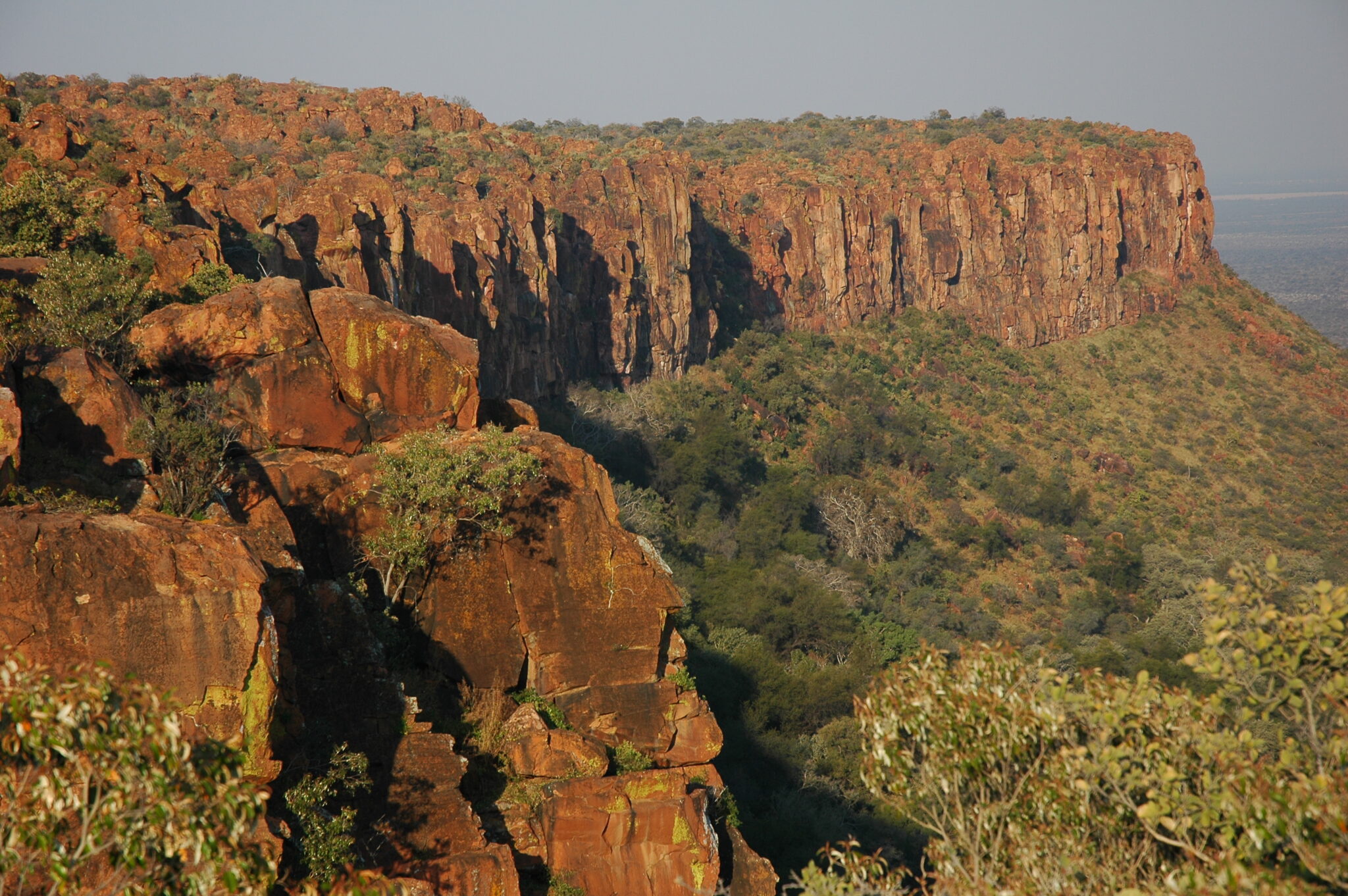
Waterberg Plateau Park
Waterberg Plateau Park is a scenic “tabletop” massif in central Namibia, best known for its flat-topped plateau, red sandstone cliffs, and cooler, greener feel compared with the open pans of Etosha. The plateau rises sharply above surrounding plains, creating strong viewpoints and a good hiking setting, with routes that climb to cliff edges and lookouts rather than long-distance trekking. Wildlife viewing is quieter and more low-key than in Etosha, but you can still see antelope species and birdlife, and the park is also associated with conservation work for rare species, which adds context if you like nature beyond game drives. The experience is at its best early or late in the day, when the cliffs glow warmer and the air is noticeably more comfortable for walking.
Waterberg fits naturally as an overnight break on a Namibia self-drive route. From Windhoek, it is typically around 280–320 km (often 3.5 to 4.5 hours by road depending on stops), and from Etosha’s southern gateways it is commonly in the 200–250 km range (often 2.5 to 3.5 hours). That makes it an easy midpoint stop to break up longer travel days while still delivering a distinct landscape. If hiking is your priority, stay overnight and start early: morning light is best for photos, temperatures are lower, and short trails to viewpoints feel far more enjoyable before heat and wind build later in the day.
Best Desert and Scenic Landmarks
Sossusvlei
Sossusvlei is Namibia’s signature desert scene: a pale clay pan ringed by some of the world’s tallest sand dunes in the Namib, with deep red ridges that can rise well over 300 m in the surrounding dune field. The visual impact is strongest at dawn, when the low sun creates sharp shadow lines across dune faces and the temperature is still reasonable. The classic photo circuit pairs Sossusvlei with nearby Deadvlei, where blackened camelthorn trees stand on a white pan beneath steep dunes, and short walks on the pans plus a dune climb (often Dune 45 for a quicker option, or Big Daddy for a harder climb) can easily fill a morning. Expect heat to build fast after mid-morning, and wind can add sand-blown conditions, so the “best window” is usually the first 2 to 3 hours after sunrise.
Access is via Sesriem, the main gateway settlement at the park entrance. From Windhoek, Sesriem is roughly 345–350 km by road, commonly 5–7 hours depending on whether you take more gravel sections and how often you stop. From Swakopmund or Walvis Bay, the drive is typically 300–370 km and often 5–7 hours (routes vary between faster corridors and more scenic gravel). From Lüderitz, plan about 300–350 km and around 4.5–6.5 hours. Once you pass Sesriem, Sossusvlei lies about 60–65 km inside the park; the final sandy stretch is a common bottleneck, and many travelers use a 4×4 or a shuttle if their vehicle is not suited to deep sand.
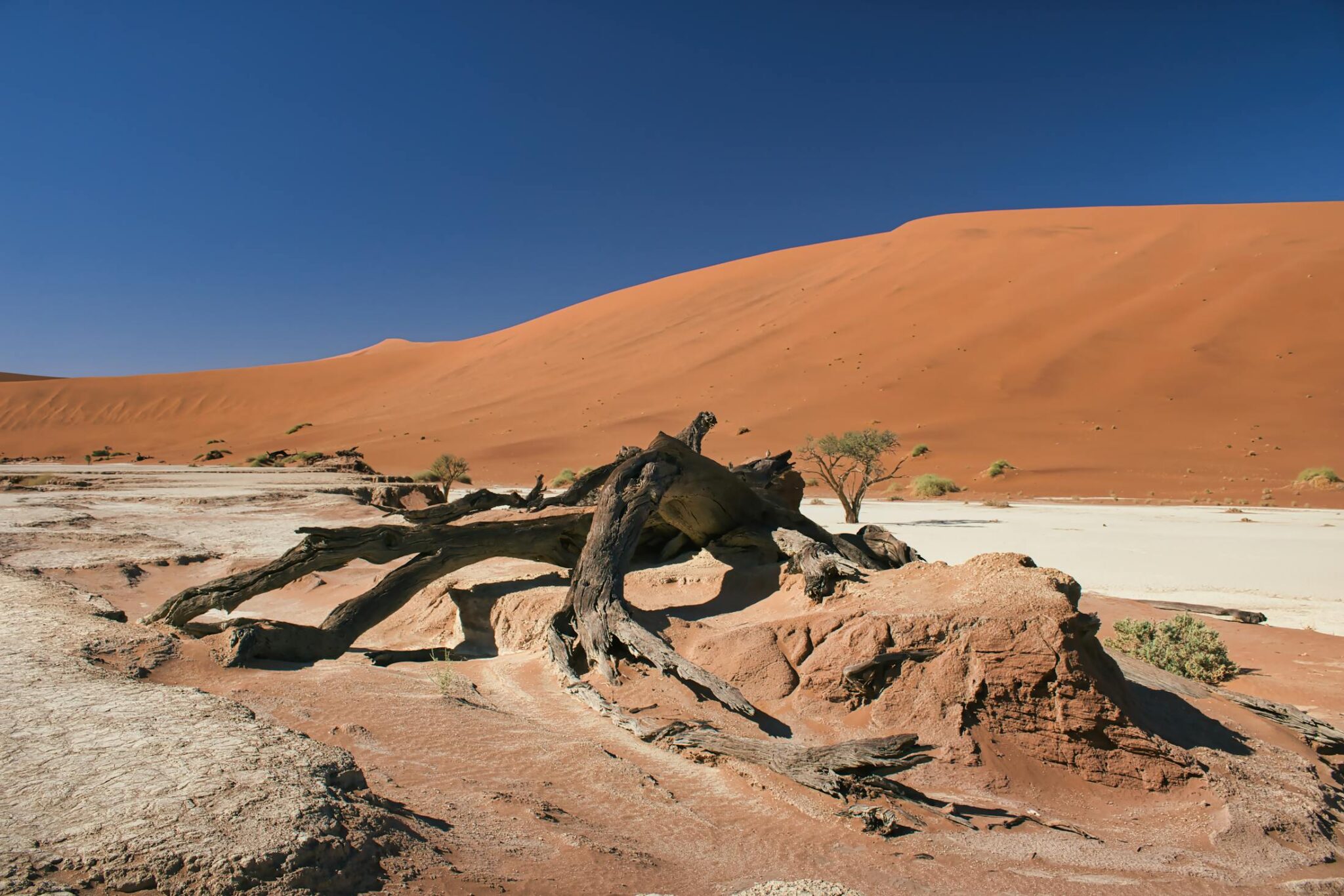
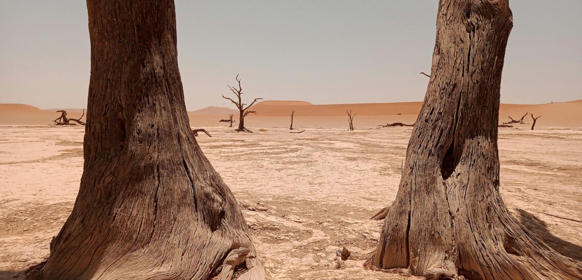
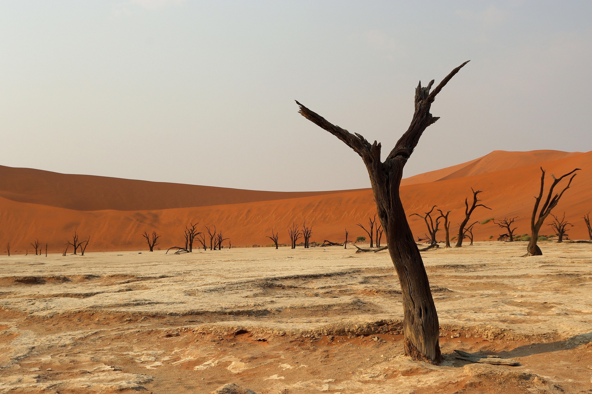
Deadvlei
Deadvlei is a stark white clay pan near Sossusvlei, famous for its blackened camelthorn trees (Vachellia erioloba) set against red dunes that rise several hundred meters. The pan formed when the Tsauchab River once flooded this basin; when the climate dried, the trees died, and the arid conditions preserved them rather than letting them decay. Many estimates place the trees at roughly 600 to 900 years old, and the contrast is at its most dramatic in clear morning light, when shadows still cut across the dunes and the white pan has a clean, bright tone before heat haze builds.
Access is usually staged from Sesriem: you drive about 60 to 65 km into the park toward Sossusvlei, then continue on the final sandy section (often treated as 4×4-only) to the Deadvlei area. If you are not in a 4×4, most people park at the 2WD lot and take a shuttle for the sandiest stretch, then walk the last 1 to 1.5 km across soft sand into the pan.
Dune 45
Dune 45 is the most accessible “iconic dune climb” in the Sossusvlei area, sitting directly off the main park road about 45 km from the Sesriem gate, which is where its name comes from. It rises to roughly 170 m, so it is challenging enough to feel like a real dune ascent without requiring a long approach or complex navigation. The reward is classic Namib scenery: a ridge-top walk with wide views over parallel dune lines, sharp shadow patterns at low sun angles, and a strong sense of scale that comes from seeing dunes stretch to the horizon. Sunrise is the signature time because the first light creates deep contrast on the dune faces, but late afternoon can be similarly photogenic with warmer tones and softer heat.
From Sesriem, the drive to the Dune 45 parking area is usually 35 to 45 minutes depending on traffic and stops, which makes it an easy add-on even if you are also planning Deadvlei. Most climbers take about 45 to 90 minutes to reach the crest depending on pace and sand conditions, then another 20 to 45 minutes to descend, with descent sometimes feeling harder because feet slide in soft sand and knees take more strain.
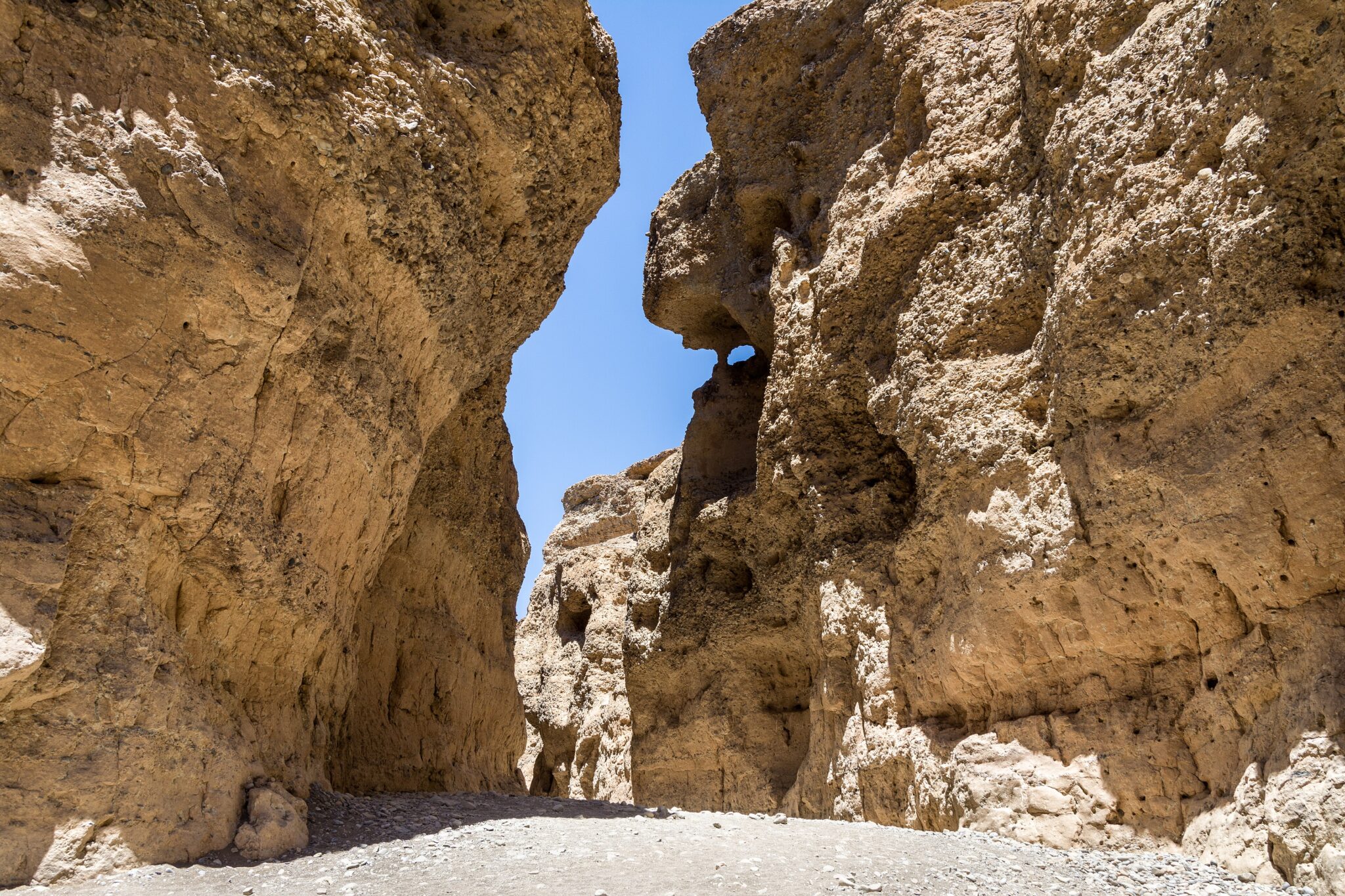
Sesriem Canyon
Sesriem Canyon is a compact but scenic gorge close to the Sesriem gate, and it is one of the easiest ways to add variety to a Sossusvlei-focused day. The canyon is roughly 1 km long and typically up to about 30 m deep, cut by the usually dry Tsauchab River into hard desert sediment. What you get here is a different texture from the dunes: shaded rock walls, cooler pockets of air, and short sections where you can walk down into the canyon floor and follow it between narrow sides. In the best light, the rock layers show clear color shifts and smoother, water-worn shapes that make it a strong “quick stop” for photos and a short leg-stretch after driving.
Best Coastal and Marine Destinations
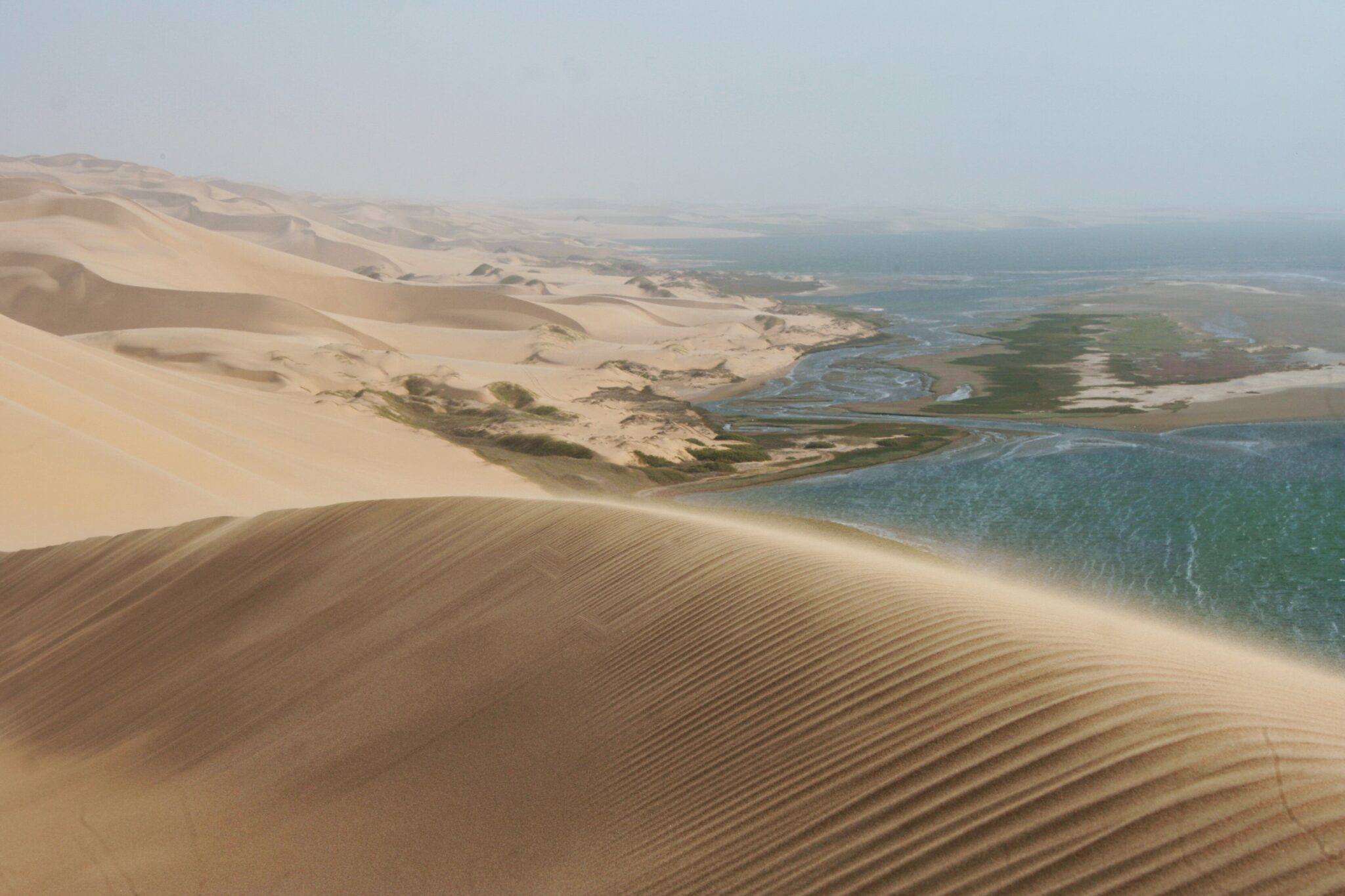
Sandwich Harbour
Sandwich Harbour is one of Namibia’s most dramatic “desert meets ocean” locations, where steep dune walls plunge directly into the Atlantic and the usable beach corridor narrows with the tide. The scenery is the headline: tall golden dunes (often well over 100 m in places), a hard-edged shoreline, and constant coastal wind and fog that can make the landscape feel cinematic. Many tours also include time around the lagoon and salt-marsh fringes, where birdlife can be excellent, especially when conditions are calm, so the outing blends pure scenery with a strong coastal-wetland atmosphere rather than being only a dune stop.
Access is almost always by guided 4×4 because the route is soft sand and beach driving that depends on tide timing and safe driving lines. Most trips depart from Walvis Bay (the closest base) or Swakopmund (about 35 km north of Walvis Bay, usually 30–40 minutes by road), then continue south toward Sandwich Harbour. The drive from Walvis Bay to the main Sandwich Harbour area is commonly 50–60 km, but total tour time is typically 4–6 hours because speeds are low, stops are frequent, and the safest route can change with tides and sand conditions.
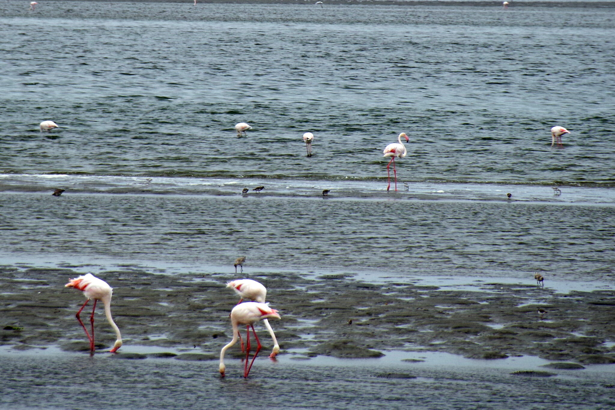
Walvis Bay Lagoon
Walvis Bay Lagoon is Namibia’s most accessible wetland stop on the coast, a sheltered, shallow water body that attracts large numbers of birds, including flamingos when conditions are right. The lagoon is part of the Walvis Bay wetland system, which is internationally important for shorebirds and waterbirds, so even a short visit can be productive for birdwatching. The best experience is simple and low-effort: a waterfront walk along the lagoon edge, slow scanning for flamingos and waders, and time for photos when the light is softer and reflections sit cleanly on the water. It is an ideal “nature break” if you want something scenic without a long drive or strenuous activity.
Getting there is easy from anywhere in Walvis Bay, usually a short taxi ride of 5 to 15 minutes depending on where you are staying. From Swakopmund, the lagoon is an uncomplicated day trip, about 35 km away and typically 30 to 40 minutes by road. If you are combining it with marine time, boat departures usually leave from the harbor area, and the lagoon walk can fit neatly before or after a cruise.
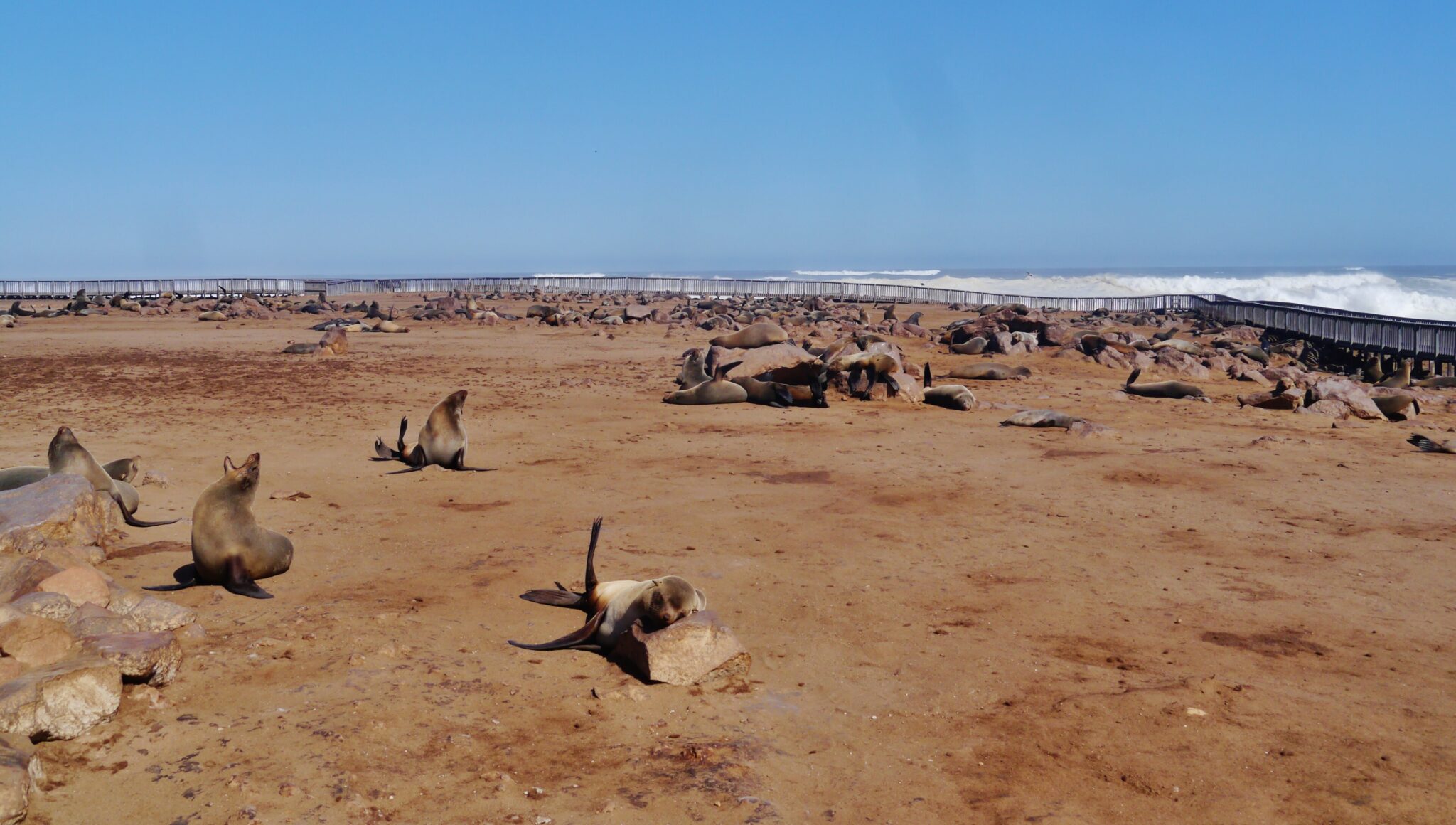
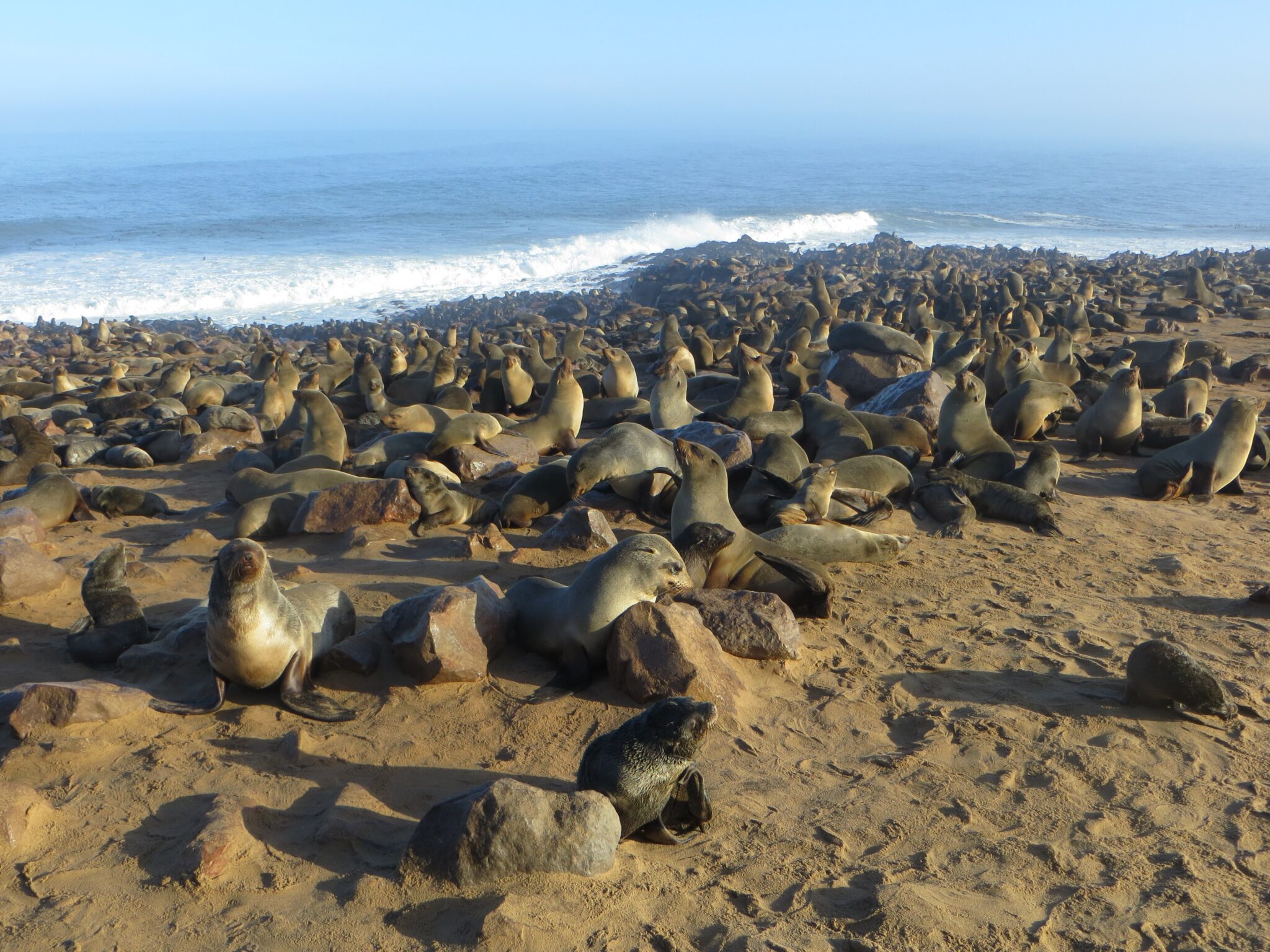
Cape Cross Seal Reserve
Cape Cross Seal Reserve is one of Namibia’s most memorable wildlife stops, built around the world’s largest breeding colony of Cape fur seals. The reserve was proclaimed in 1968 and covers about 60 km², with wooden walkways that take you close enough to see the colony’s constant motion: bulls holding territory, mothers nursing pups, and seals streaming in and out of the surf. The spectacle peaks in the breeding season (November to December), when seal numbers can rise to around 210,000 and the colony becomes exceptionally dense and noisy. Even outside peak season, you will usually see thousands of seals, and the experience is less about “spotting” and more about watching behavior at scale. The main reality check is the odor, which can be intense in warm or still conditions, so many visitors find that 30–60 minutes is enough to appreciate the scene without lingering too long.
Getting there is straightforward on the Skeleton Coast route. Cape Cross is about 120–130 km north of Swakopmund on the coastal road, typically 1.5 hours by car, and about 60 km north of Henties Bay, roughly 45–60 minutes depending on stops and road conditions. Many travelers visit it as a half-day outing from Swakopmund or Walvis Bay, with Walvis Bay to Swakopmund being about 35 km (around 30–40 minutes) before continuing north. From Windhoek, plan roughly 430–455 km by road, commonly 4.5–5 hours to reach Cape Cross, which is why most itineraries overnight on the coast first.
Best Cultural and Historical Sites
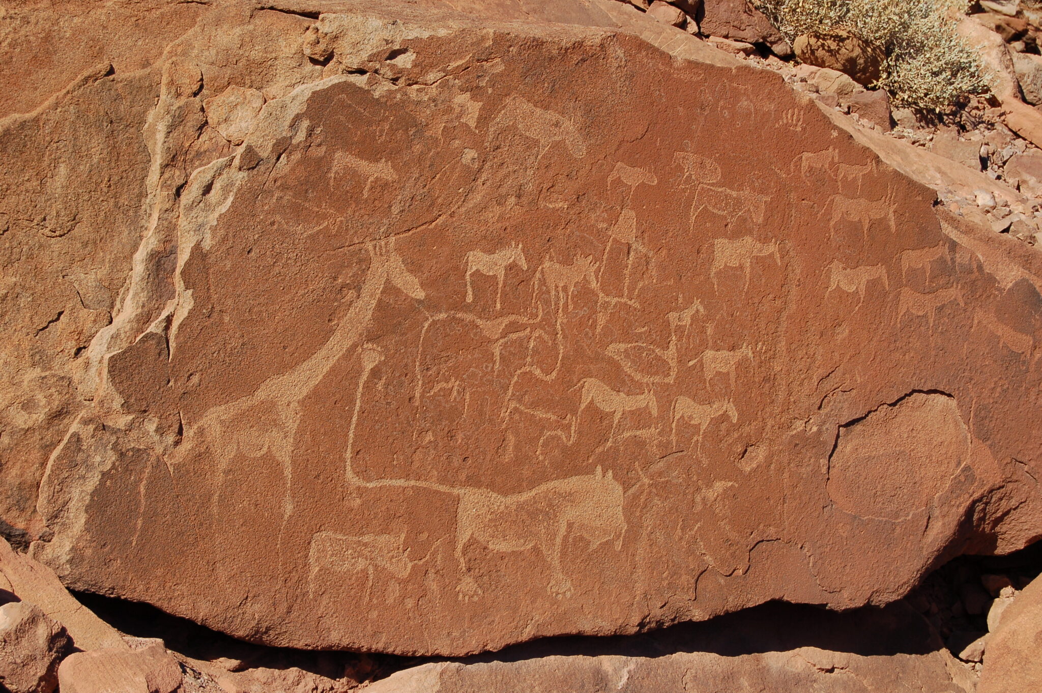
Twyfelfontein
Twyfelfontein is Namibia’s most significant rock art site and the country’s first UNESCO World Heritage listing (2007). The core area is small, about 57 hectares, but it contains an exceptionally dense concentration of engravings, commonly cited at 2,500+ individual carvings, created over millennia by hunter-gatherer and later pastoral communities. The experience is best with a guide because the value is in interpretation: you will see animal engravings (giraffe, elephant, rhino and other species), track-like motifs, and ritual symbols etched into desert-varnished sandstone. The setting is also part of the story: a rare spring in an arid zone (annual rainfall is often cited at under 150 mm), which helps explain why people returned here repeatedly for thousands of years.
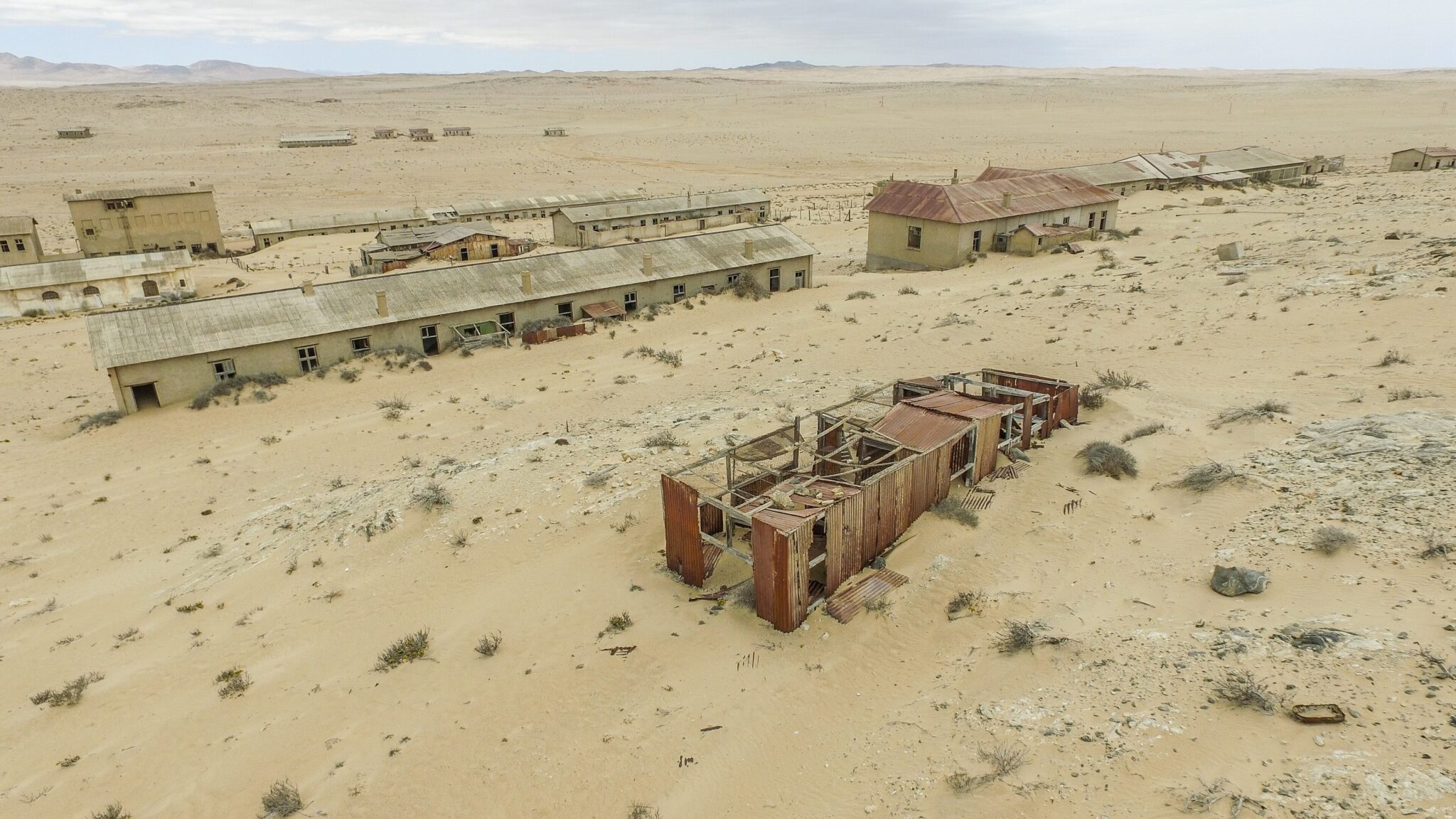
Kolmanskop
Kolmanskop is an abandoned diamond-mining settlement about 10 km east of Lüderitz, established in the early 1900s after diamonds were discovered in the area in 1908. At its peak it functioned like a self-contained company town, with substantial German-era buildings, utilities, and services that were unusually modern for a remote desert outpost. Today the draw is the atmosphere: sand dunes have invaded the streets and rooms, creating sculpted interiors that change month to month with wind and light. The best time to visit is early morning, when shadows add depth to the sand patterns and temperatures are lower. Plan 1.5 to 3 hours on site if you want to move slowly between buildings and photograph interiors, and protect equipment from dust and wind.
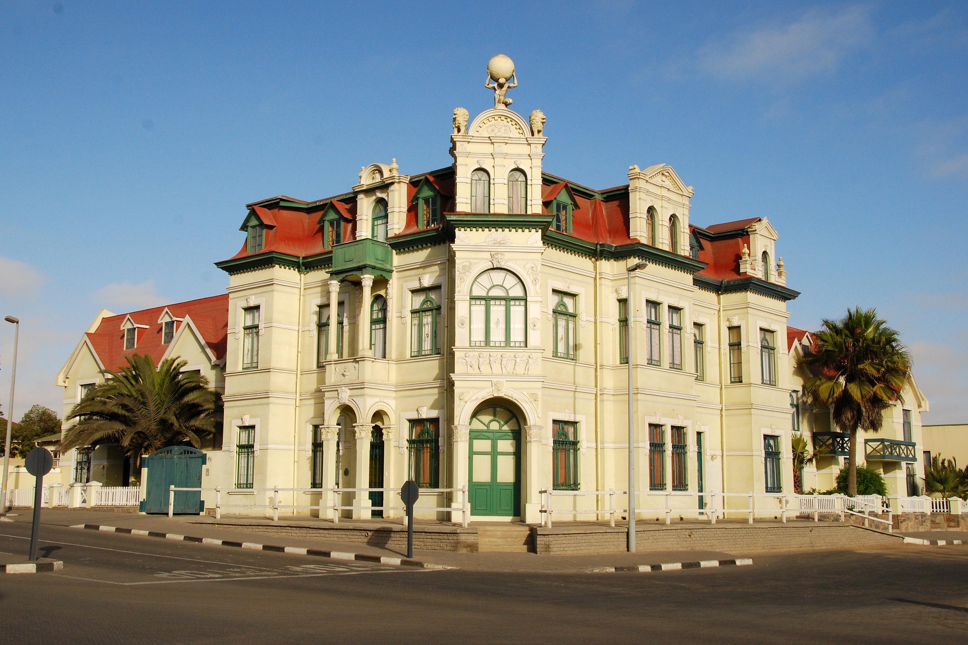
Independence Memorial Museum (Windhoek)
The Independence Memorial Museum is Windhoek’s most useful cultural stop for understanding Namibia’s colonial period, liberation struggle, and independence era. The building is centrally located and designed for an efficient visit, with exhibitions that give a structured overview of key historical periods and national narratives, making it a strong “orientation” stop before you head into the regions. Plan roughly 1 to 2 hours for a focused visit, longer if you prefer to read displays in detail and take your time with photographs and timelines.
It is easy to combine the museum with nearby, walkable city stops. From the museum area you can add a short city loop through central Windhoek, then continue to a craft stop such as the Namibia Craft Centre, which is a practical place for textiles, baskets, and small gifts without long detours. Most visitors can complete the museum, a short walk, and a craft market visit in a half-day, leaving the afternoon free for vehicle pickup, shopping for water and supplies, and final checks before driving into more remote areas.
Hidden Gems and Off the Beaten Path
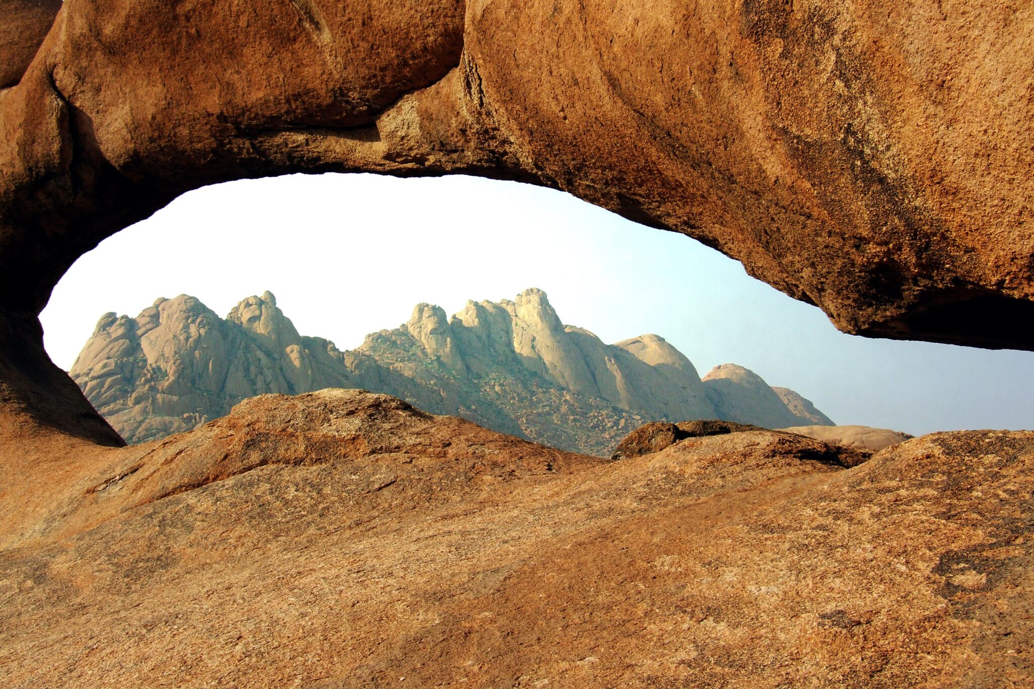
Spitzkoppe
pitzkoppe is one of Namibia’s most striking granite landscapes, a cluster of bare rock domes and spires rising abruptly from open plains, with the highest peak reaching about 1,728 m. It is often called the “Matterhorn of Namibia” for its sharp profile, and it works especially well for travelers who want walking routes, boulder scenery, and night-sky photography without the crowds of the main dune corridor. The highlights are simple and visual: short hikes to viewpoints and natural arches, warm sunrise and sunset color on the granite faces, and exceptionally dark skies once the light drops. If you are interested in heritage, the area also has San rock art sites, usually visited with local guidance.
Access is straightforward for self-drive. Spitzkoppe lies roughly 120 km inland from Swakopmund (commonly 1.5 to 2 hours by road), and about 280–300 km from Windhoek (often 3.5 to 4.5 hours depending on route and stops). Many people pair it with Swakopmund, Walvis Bay, or the Erongo region as a one- or two-night segment, because it breaks up longer drives while still delivering a distinct landscape.
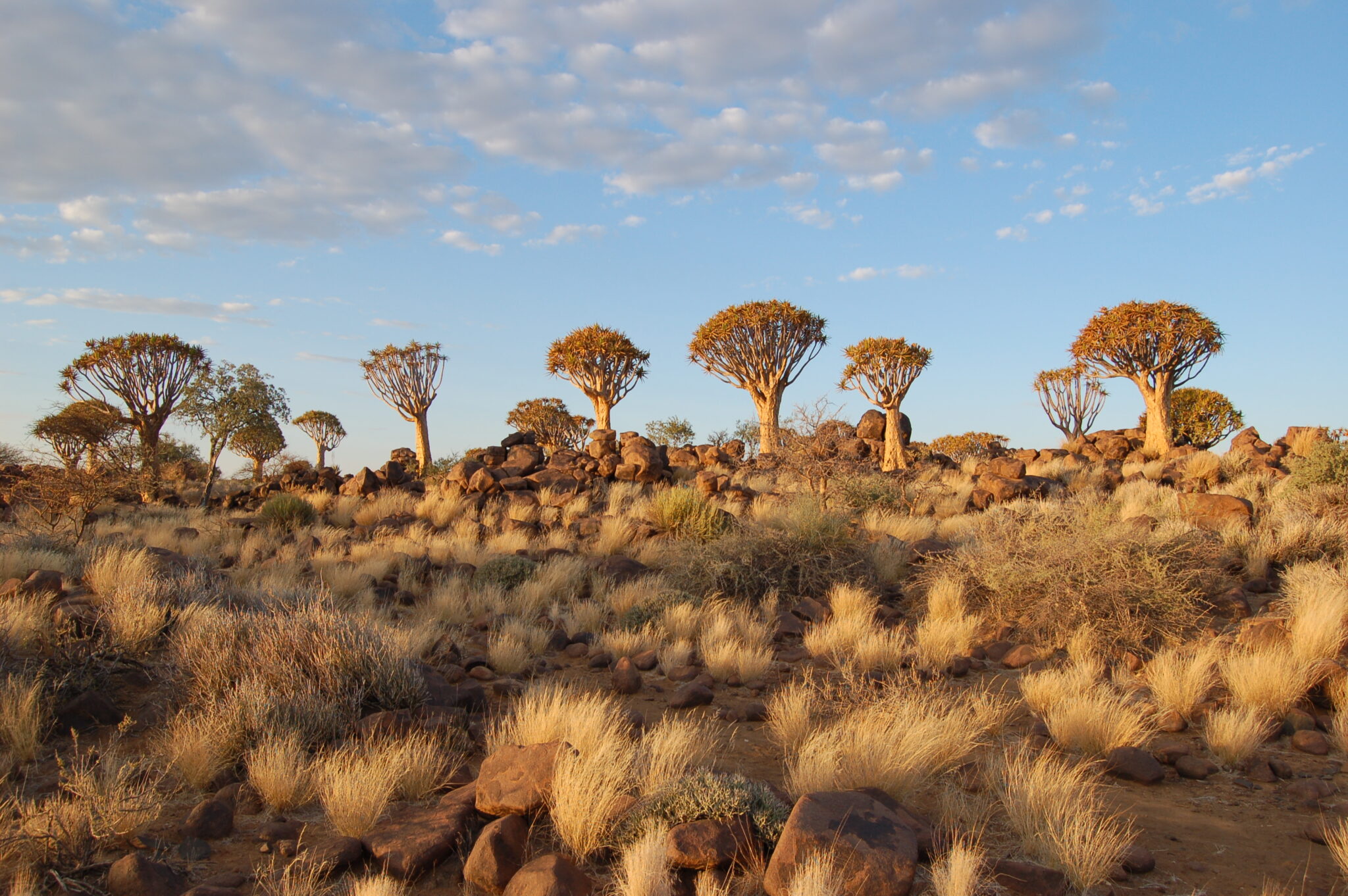
Quiver Tree Forest (Keetmanshoop area)
The Quiver Tree Forest near Keetmanshoop is a compact natural “forest” of around 250 quiver trees (Aloidendron dichotomum), scattered across rocky ground in southern Namibia. These are not typical trees but giant tree aloes, often reaching 7 m (sometimes up to 9 m) with pale, reflective bark and forked crowns that look sculptural in desert light. Many of the largest specimens are estimated to be 200 to 300 years old, and in late afternoon the low sun turns the trunks golden while the plants cast long, graphic shadows. It is a photographer-friendly stop because the scene is strong even without a long hike: you can walk short loops, frame individual trees against open sky, and capture silhouettes as the light softens. Getting there is easy from Keetmanshoop, typically 13 to 17 km northeast (around 15 to 25 minutes by car, depending on the exact turn-off and road conditions). Most visitors combine it with the nearby Giants’ Playground rock formations on the same outing, which adds variety without adding major driving time.
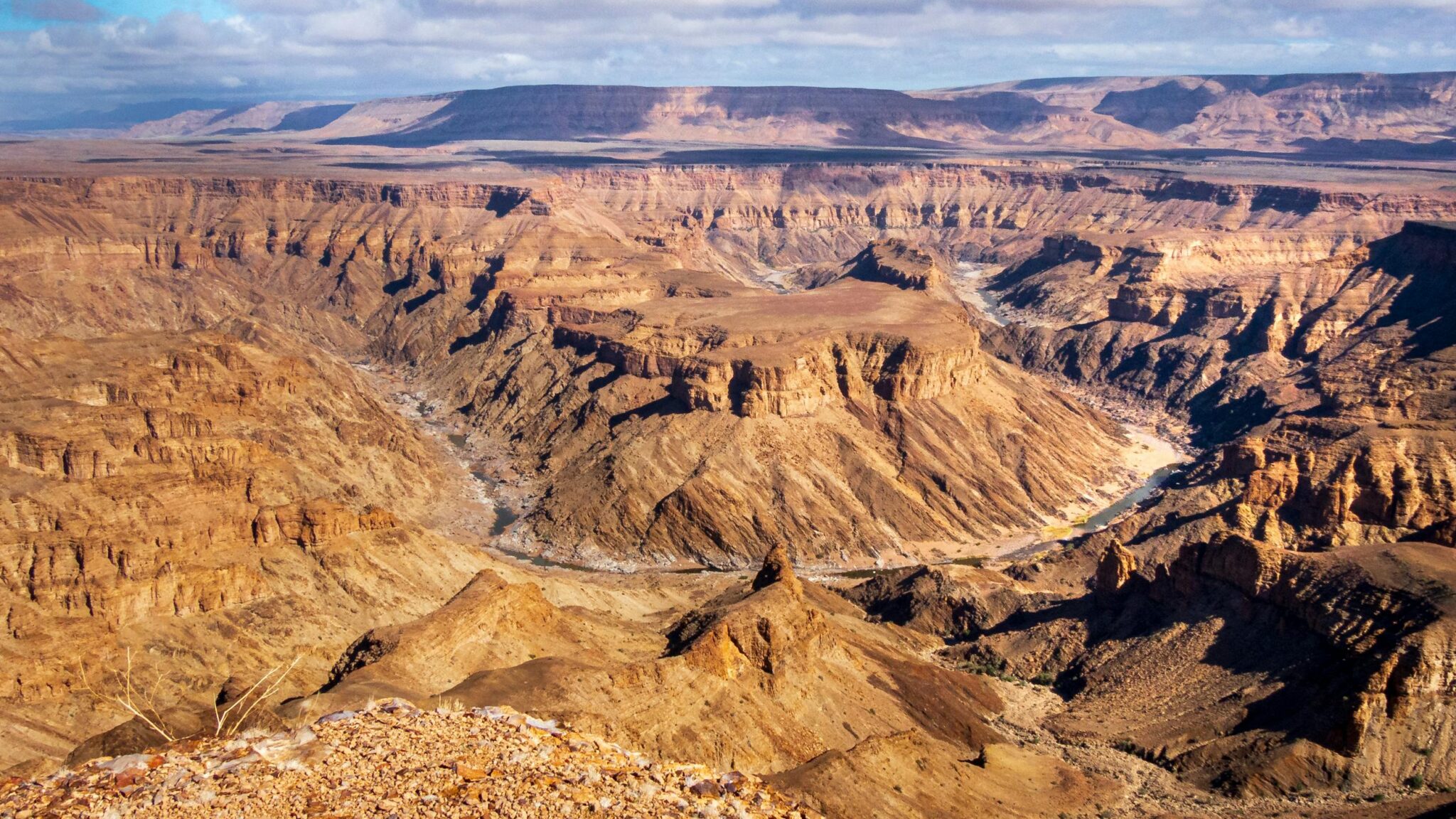
Fish River Canyon viewpoints
Fish River Canyon is one of southern Africa’s most dramatic landscapes, with a deeply incised gorge that runs for roughly 160 km, reaches up to about 27 km wide in places, and drops around 500–550 m from rim to riverbed. The best experience is rim-based: you drive between established viewpoints and stop for wide, panoramic looks that show the canyon’s scale, layered rock walls, and the winding course of the (usually seasonal) Fish River far below. The classic viewpoint area is Hobas, where several lookouts sit close enough together to combine in 1–2 hours without rushing, especially if you time it for early morning or late afternoon when shadows add depth and the heat is less intense.
Access is typically by road and works best as a planned segment due to long distances. Most visitors approach via Keetmanshoop or Seeheim: from Keetmanshoop to the Hobas area is commonly about 500 km (often 5–6+ hours depending on route and stops). From Windhoek, plan roughly 650–700 km (typically 7–9+ hours with breaks), so an overnight en route is often more comfortable. From Lüderitz, the drive is also substantial at roughly 600+ km (commonly 6–8+ hours depending on routing via Aus and the B4 corridor).
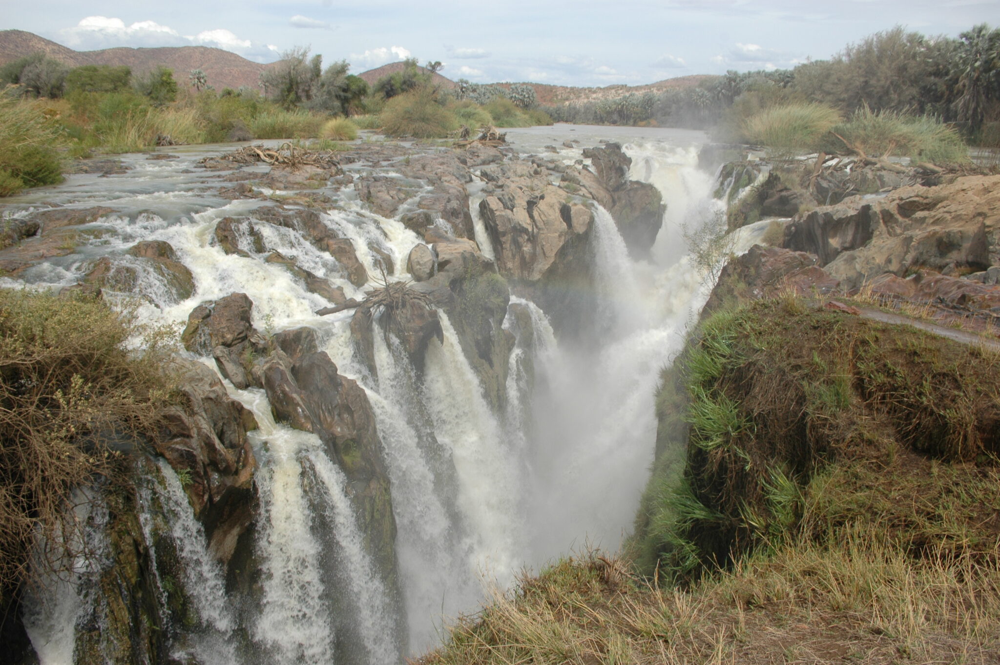
Epupa Falls
Epupa Falls is one of Namibia’s most rewarding “far-north” destinations, set on the Kunene River at the border with Angola. The falls are not a single drop but a series of cascades spread across rocky channels, with the main drop commonly cited at around 37 m and the full waterfall line extending for roughly 1.5 km when the river is flowing well. The setting is greener than the desert corridor, with riverine palms and fig trees, and the cultural layer is real: this is Himba territory, so the region often combines landscape time with careful, respectful community visits arranged through local introductions. The best experiences are simple: walking the rim paths for different angles, sitting with the sound and spray at sunset, and doing short river-side hikes to viewpoints where you can see how the Kunene cuts through otherwise dry country.
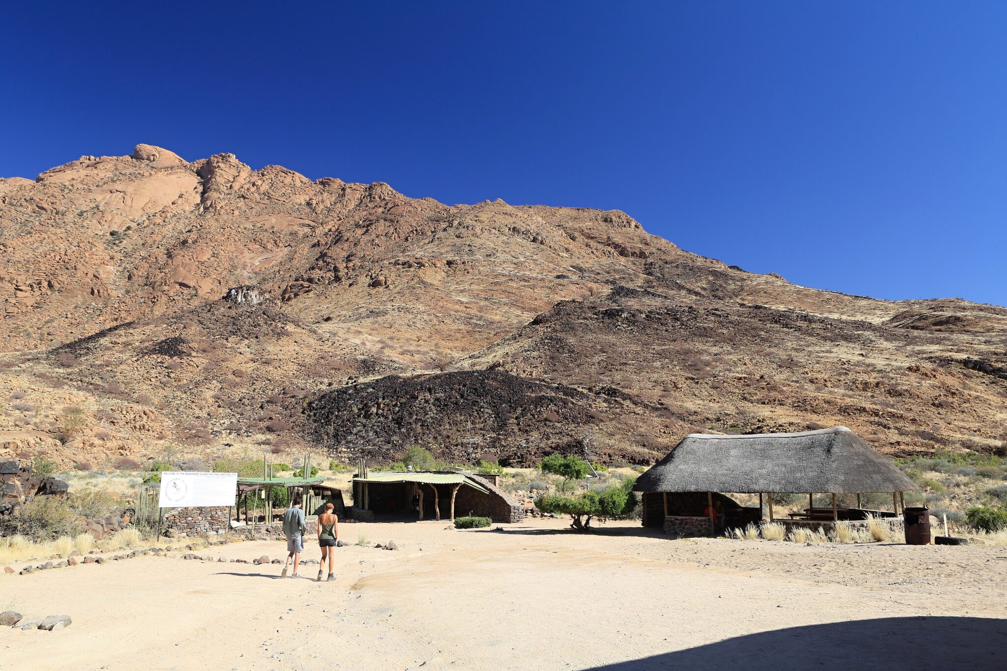
Brandberg (White Lady area)
Brandberg is Namibia’s highest mountain massif, rising to about 2,573 m at Königstein, and it stands out as a huge granite dome above the Damaraland plains. The main draw for visitors is the White Lady rock painting, one of the best-known panels in the Brandberg’s rock art collection, reached on a guided hike through the Tsisab Gorge area. The walk is not technical, but it is exposed and can feel demanding in heat: plan roughly 5 to 8 km on foot (route dependent) and typically 2 to 3 hours each way, plus time at the panel. What makes the outing special is the combination of desert-mountain scenery, boulder-strewn valleys, and the heritage context. The Brandberg holds thousands of recorded rock art sites, so even this single hike gives you a sense of how densely the massif was used and revisited over long periods.
Travel Tips for Namibia
Safety and General Advice
Namibia is one of Africa’s safest and most traveler-friendly destinations, well-suited to both guided tours and independent travel. The country’s vast landscapes and low population density make it ideal for road trips, but travelers should plan carefully. Distances between towns are long, and fuel stations and services can be sparse in remote areas. Always carry extra water, fuel reserves, and offline navigation tools when exploring rural regions or national parks.
A yellow fever vaccination may be required depending on your route of entry. Malaria risk varies across the country – it is low in central and southern regions but higher in the northern and Zambezi areas, where prophylaxis is recommended. Tap water is generally safe in major towns but not always reliable in remote areas, so bottled or filtered water is the best choice. Travelers should also bring sunscreen, insect repellent, and basic first-aid supplies for long drives or outdoor excursions.
Car Rental and Driving
An International Driving Permit is recommended alongside your national driver’s license. Both should be carried at all times, especially when renting vehicles or passing through checkpoints. Road rules are strictly enforced, and safe, responsible driving is essential in Namibia’s open and isolated environments. Driving in Namibia is on the left-hand side of the road. A high-clearance vehicle is strongly recommended, and a 4×4 is essential for reaching remote areas, such as Sossusvlei, Damaraland, or the Skeleton Coast, where sand and gravel dominate the terrain. Night driving outside towns is not advised due to the risk of wildlife crossings and low visibility.
An International Driving Permit (IDP) is recommended alongside your national driver’s license. Both should be carried at all times, especially when renting vehicles or passing through checkpoints. Road rules are strictly enforced, and safe, responsible driving is essential in Namibia’s open and isolated environments.
Published January 25, 2026 • 23m to read