Ethiopia is one of Africa’s most historically significant destinations, known for its UNESCO-listed sites, highland landscapes, rock-hewn churches, and cultures that developed largely independent of outside influence. History, religion, architecture, and daily life are closely linked, giving travel here a strong educational dimension alongside striking scenery. From ancient cities to dramatic escarpments and plateaus, Ethiopia offers depth rather than spectacle alone.
The country suits travelers interested in history and architecture, as well as hikers and photographers drawn to highland light and scale. Practical planning matters. Distances are substantial, road travel can be slow, and domestic flights often make itineraries far more efficient. Some regions also require additional preparation and local coordination. Well-considered routing is key to keeping the journey balanced and rewarding rather than tiring.
Best Cities in Ethiopia
Addis Ababa
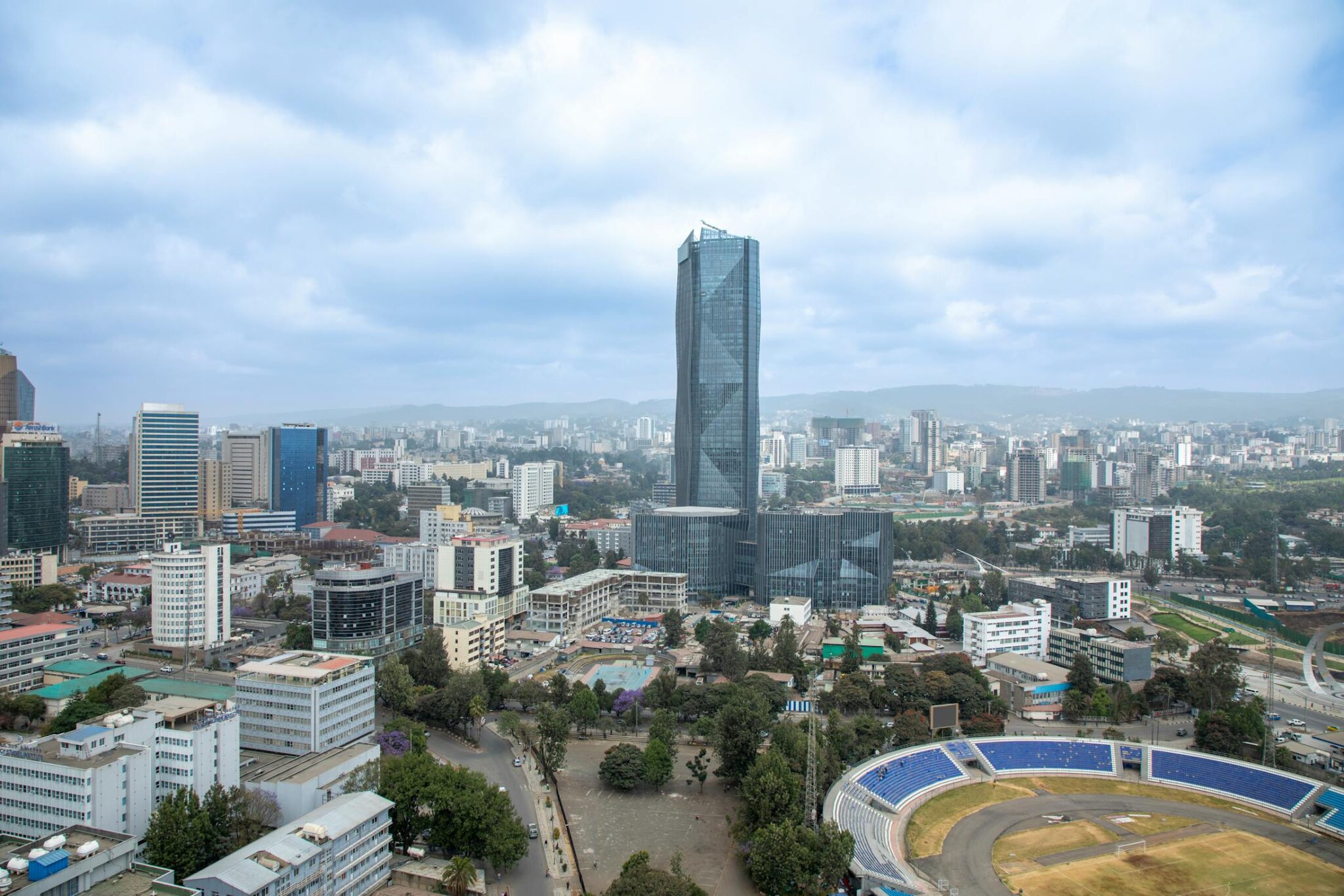
Addis Ababa is Ethiopia’s best “context city” before you head north to the historic circuit or out to the highlands, partly because it sits at high elevation, around 2,350 m, and partly because its museums explain the country’s long timeline clearly. The National Museum of Ethiopia is the highest-value stop for deep history, and it works well in 60 to 90 minutes if you keep a steady pace, or 2 hours if you want to read displays carefully. The Ethnological Museum adds culture and daily-life perspective and is usually a 60 to 120 minute visit. For heritage, Holy Trinity Cathedral is a strong short stop of 30 to 60 minutes, and the Entoto Hills are the best nearby viewpoint break, with ridgelines rising to roughly 3,000 to 3,200 m, which is why the air can feel noticeably cooler and thinner than in the city.
A practical first day is one museum block, one heritage stop, then one viewpoint or café window, rather than stacking 5 or 6 locations. Mercato can be intense, so treat it as a 30 to 60 minute guided visit focused on one section, keep valuables discreet, and avoid wandering aimlessly. Addis is also where coffee becomes a cultural activity: a traditional coffee ceremony can take around 45 to 90 minutes and is one of the most memorable low-effort experiences in the city. For logistics, Bole International Airport is relatively close to central districts in distance, often around 5 to 10 km, but transfers commonly take 20 to 60 minutes depending on traffic, so build buffer time, especially if you have a same-day departure to the north.
Gondar
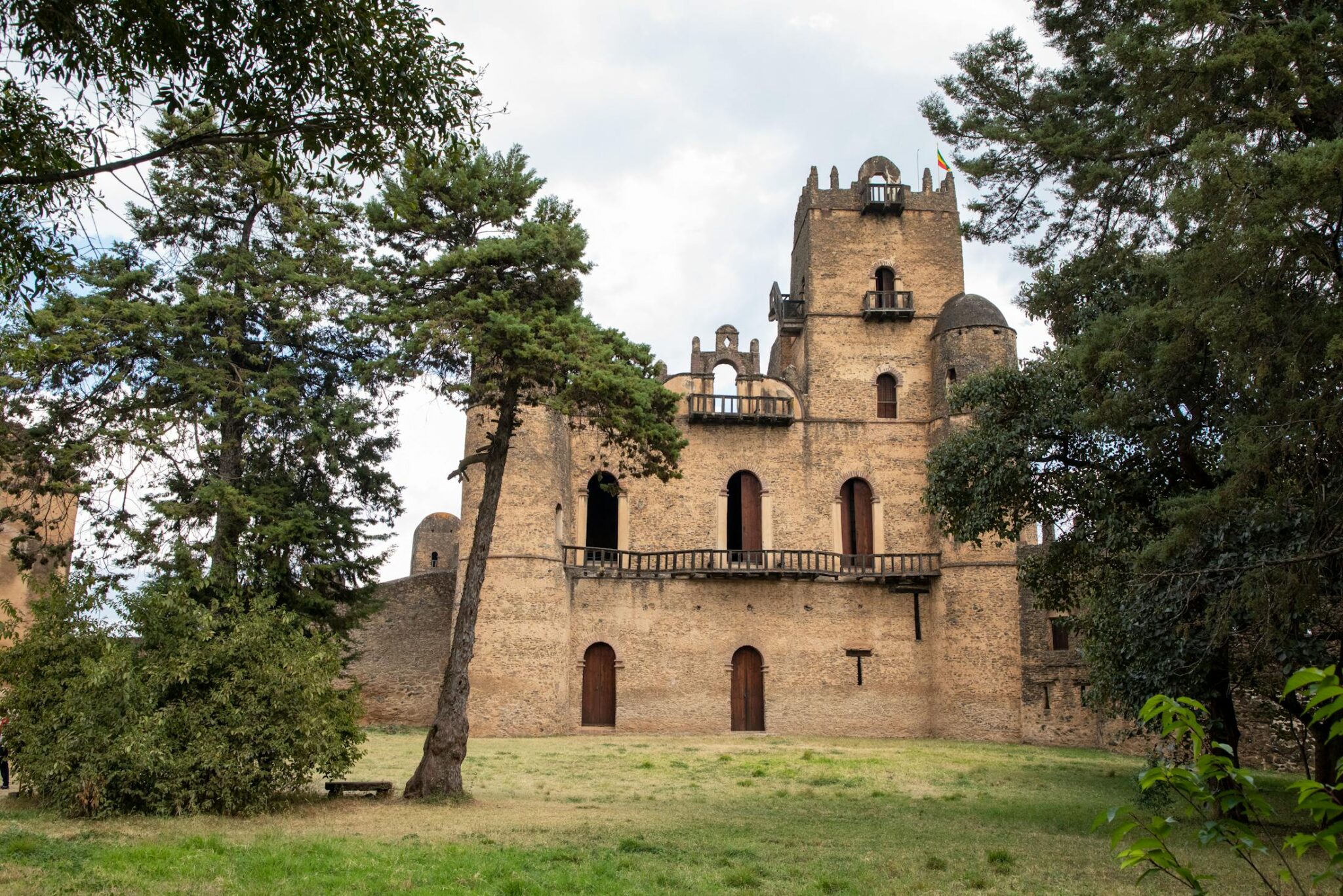
Gondar is Ethiopia’s classic “royal city”, founded as an imperial capital in the 17th century under Emperor Fasilides, and it remains one of the most time-efficient heritage stops in the country because the key sites are close together. The main anchor is Fasil Ghebbi (the Royal Enclosure), a UNESCO-listed complex inscribed in 1979, with stone castles, banquet halls, and fortified gates that reflect Gondar’s peak as a court city. Plan 2 to 3 hours for a proper visit if you want to move slowly between the main structures and viewpoints inside the walls. Add Fasilides’ Bath as a short extra stop, especially if your timing aligns with local festival periods when the site is at its most atmospheric.
For church art, Debre Berhan Selassie is the essential second pillar of a Gondar visit, best known for its interior paintings and the famous ceiling of repeated angel faces. It is typically an easy 45 to 90 minute stop, and it pairs well with one additional half-day excursion to avoid overloading your schedule. Good add-ons include Qusquam (Kuskuam), a hillside royal complex with quieter ruins and views, or a longer day trip toward the Simien gateway: Debark is roughly 100 km from Gondar and often 2.5 to 4 hours by road each way, making it realistic if you want a highland viewpoint or a first taste of Simien landscapes without committing to a full trekking itinerary. For routing, Gondar links naturally with Bahir Dar (roughly 180 km, often 3.5 to 5.5 hours by road) and is commonly reached by a short domestic flight from Addis Ababa when time is tight; either way, 1 full day covers the headline sites, while 2 nights gives you breathing room for one extra monastery or viewpoint without rushing.
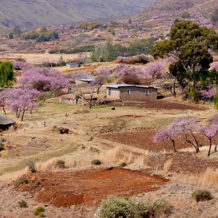
Bahir Dar
Bahir Dar is one of Ethiopia’s easiest places to slow the pace, with a relaxed lakeside feel on Lake Tana, the country’s largest lake at roughly 3,000–3,600 km² depending on season. The best experience is a morning boat trip to island and lakeshore monasteries, which adds a distinctive “water plus history” day without heavy travel. Start early for calmer water and better light, and plan 3 to 6 hours depending on how many stops you choose; shorter loops usually cover 1 to 2 monasteries, while longer circuits add more islands and a wider sense of the lake. Back in town, the lakeside promenade is ideal for a slow evening walk of 45 to 90 minutes, which works well as a reset between denser heritage days in the north.
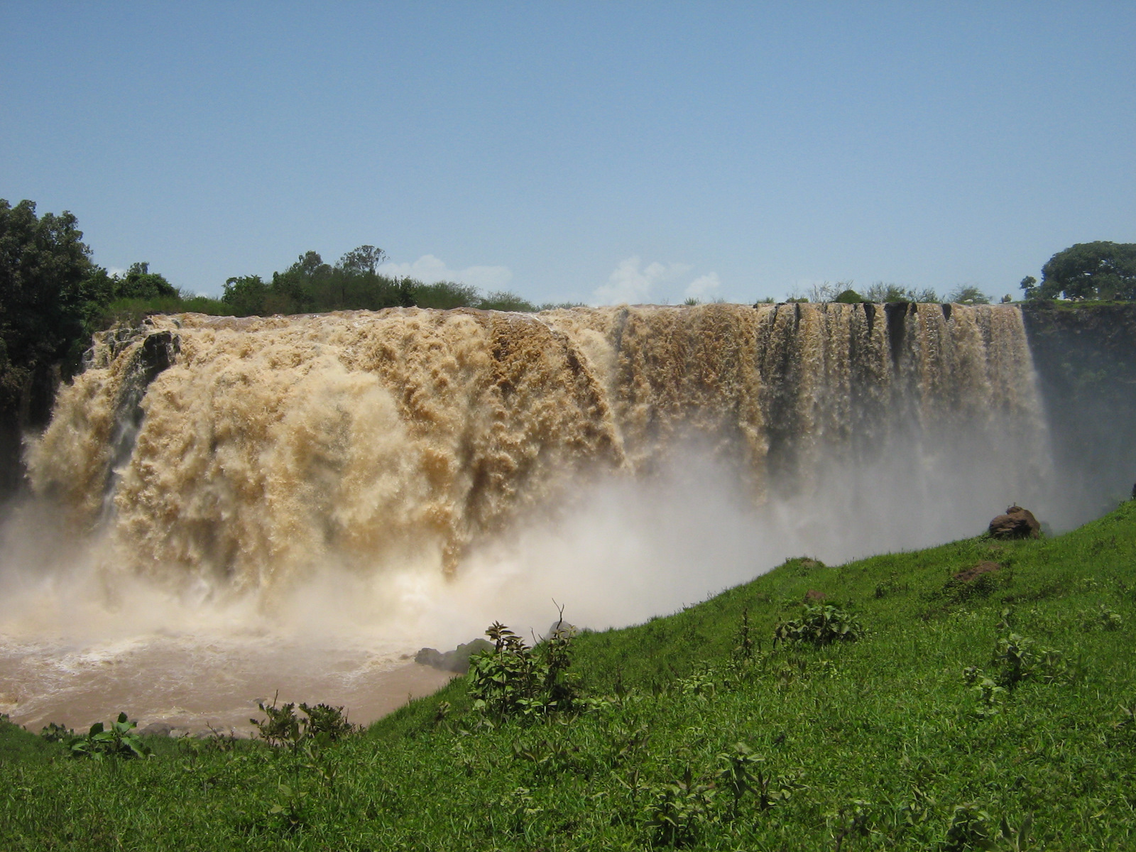
The classic add-on is a day trip to the Blue Nile Falls (Tis Issat), typically 30 to 40 km from Bahir Dar and often 1 to 1.5 hours by road each way, plus walking time on-site. Water levels matter: in higher-flow periods the falls can feel dramatic and loud, while in drier periods the flow can be reduced, but the countryside and river valley scenery can still make the trip worthwhile if you keep expectations realistic. A practical structure is 1 full day for Lake Tana monasteries, then either a second morning for the falls or a lighter lakefront day. For transfers, Bahir Dar sits naturally between Addis and Gondar routes: Bahir Dar to Gondar is roughly 180 km and often 3.5 to 5.5 hours by road, while domestic flights can save time if your schedule is tight and you want to protect daylight for sightseeing.
Lalibela
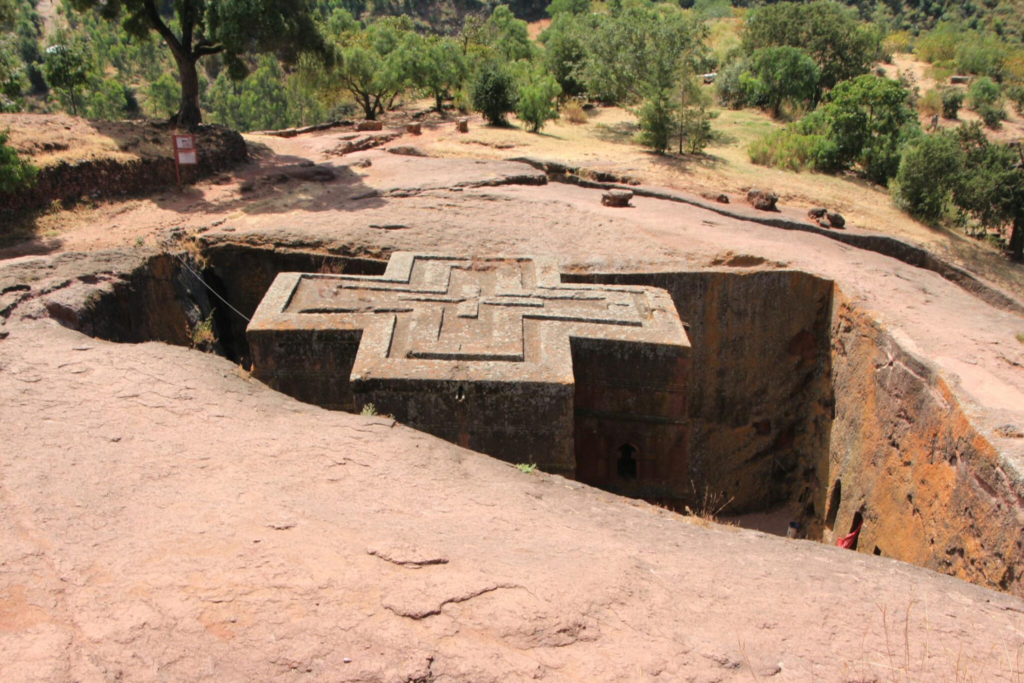
Lalibela is Ethiopia’s signature heritage stop because its rock-hewn churches are not ruins or reconstructions, they are living places of worship carved directly from volcanic tuff. The core cluster is typically described as 11 medieval churches, most associated with the late 12th to early 13th century during the Zagwe period and inscribed as a UNESCO World Heritage site in 1978. The town sits high, around 2,500 m elevation, so days can feel sunny but cool quickly in the shade and at night. The best way to visit is unhurried: plan 2 full days as a minimum, or 3 days if you want time for both the main groups, repeat visits in better light, and a quieter pace. Aim for early morning and late afternoon sessions because those windows usually bring softer light, fewer groups, and a calmer feel inside the complexes.
Beyond the main churches, Lalibela becomes even stronger if you add one hike and one “outside cluster” visit. A classic short hike is to a viewpoint church above town such as Asheton Maryam, which can take roughly 2 to 4 hours round-trip depending on route and pace, and it gives wide highland views that help you understand the landscape context. For an off-site heritage add-on, Yemrehanna Kristos is the most popular half-day trip, often reached in roughly 1.5 to 2.5 hours each way depending on road conditions, and it complements Lalibela’s rock-hewn style with a different church setting and atmosphere.
Harar
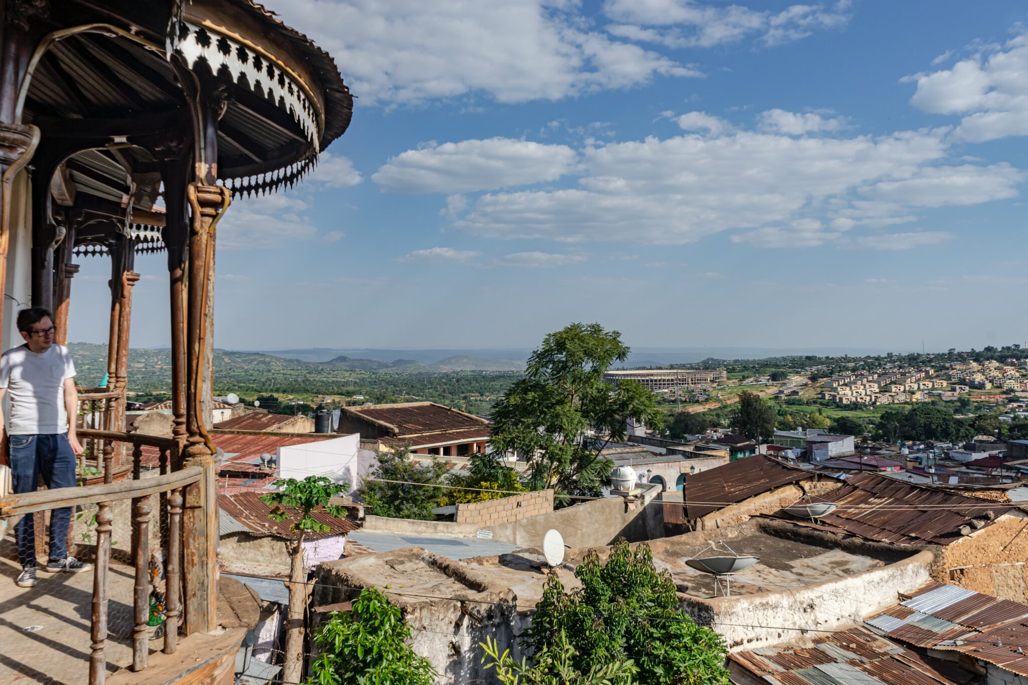
Harar is one of Ethiopia’s most distinctive culture and heritage stops, largely because its old town, Harar Jugol, is a compact walled city with a dense maze of narrow lanes, carved wooden doors, small courtyards, and dozens of mosques and shrines woven into everyday neighbourhood life. Inside the walls, the best experience is slow walking with a local guide: you will move between tiny market pockets, traditional homes, and small museums that explain how Harar became a major Islamic learning and trading centre for centuries, linking the Horn of Africa to the Red Sea and Arabian Peninsula trade routes. The old city is small enough to cover on foot in a few hours, but the point is to stop often, climb to rooftops or small viewpoints where possible, and spend time in the markets where coffee, spices, textiles, baskets, and everyday goods still dominate the scene. For photography and atmosphere, early morning and late afternoon are ideal, and staying at least one night makes a noticeable difference because the lanes feel calmer after day visitors leave.
To visit, most travellers base themselves either in Harar itself or in nearby Dire Dawa, which is roughly 55 km away and usually 1 to 2 hours by road depending on traffic and checkpoints. From Dire Dawa you can take shared minibuses or arrange a private car for a day trip, but an overnight in Harar is better if you want to explore without rushing and to catch the old town at quieter hours. From Addis Ababa, Harar is about 500 km east by road, commonly 9 to 12 hours depending on route and conditions, so many people break the journey with a stop in Dire Dawa or use a domestic flight to Dire Dawa and continue by road.
Mekelle (Tigray base)
Mekelle works best as a staging point rather than a destination you build a sightseeing-heavy schedule around. Its real value is that it is the largest transport and services hub in Tigray, so it is where you can organise a reliable vehicle, agree a realistic day plan, and coordinate local guidance for the rock-hewn churches and highland escarpments that sit within a few hours’ drive. The classic day-trip zone is the Gheralta cluster around Wukro, about 45 km from Mekelle and often under an hour by road, where dramatic sandstone outcrops hide churches such as Abune Yemata Guh and Maryam Korkor, reached via steep footpaths and short scrambles. Treat these outings like proper hikes: start early for cooler temperatures and better light, allow several hours for the approach and return, and build extra time for checkpoints, access arrangements, and slow sections of road.
Getting there is usually straightforward on paper but can be variable in practice. By air, the direct flight time between Addis Ababa and Mekelle is commonly around 1 hour 20 minutes, with a flight distance of about 505 km. By road, the Addis Ababa to Mekelle journey is long and typically planned as a multi-day drive. Within the region, Mekelle is the natural starting point for short transfers to Wukro and onward to the Gheralta trailheads, while longer days can reach additional cliffside sites if conditions allow. One critical planning note: as of late January and early February 2026, multiple governments have issued do not travel guidance for Tigray due to renewed instability, and flight operations have been subject to sudden suspensions and resumptions.
Best Natural Places in Ethiopia
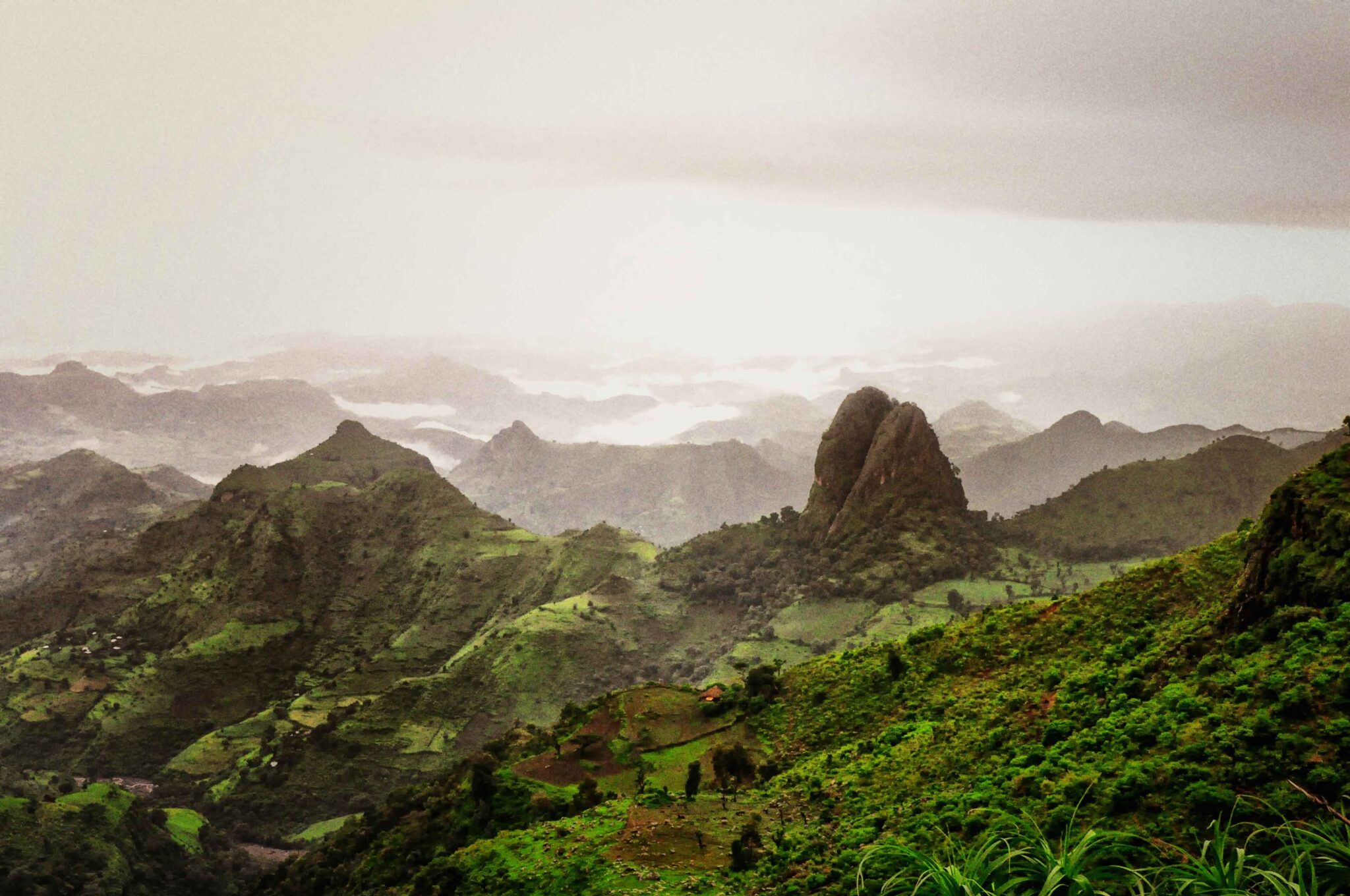
Simien Mountains National Park
Simien Mountains National Park delivers Ethiopia’s most dramatic escarpment scenery: huge cliff faces, jagged pinnacles, and valleys that drop for kilometres, with many classic viewpoints sitting around 3,000 to 3,600 m above sea level. Multi-day routes often push higher, including approaches toward Ras Dashen at roughly 4,550 m, but you do not need to summit anything to get a world-class experience. The best days start early for clearer skies and softer light, then move steadily at altitude with plenty of pauses. Expect fast-changing highland weather even in the dry season: mornings can be close to freezing at camp height, while midday sun can feel intense, so warm layers plus a windproof shell are practical year-round.
Logistically, the usual gateway is Gondar, then a road transfer to Debark, which is about 100 km and commonly around 2 hours in good conditions, followed by another drive to your chosen trailhead. Short visits can be built around half-day or full-day walks to major viewpoints and back, while 2 to 4 nights lets you link ridgelines and camps without rushing; typical trekking stages are often planned in the 10 to 15 km range, but speed depends heavily on altitude and how much time you spend at viewpoints.
Bale Mountains National Park
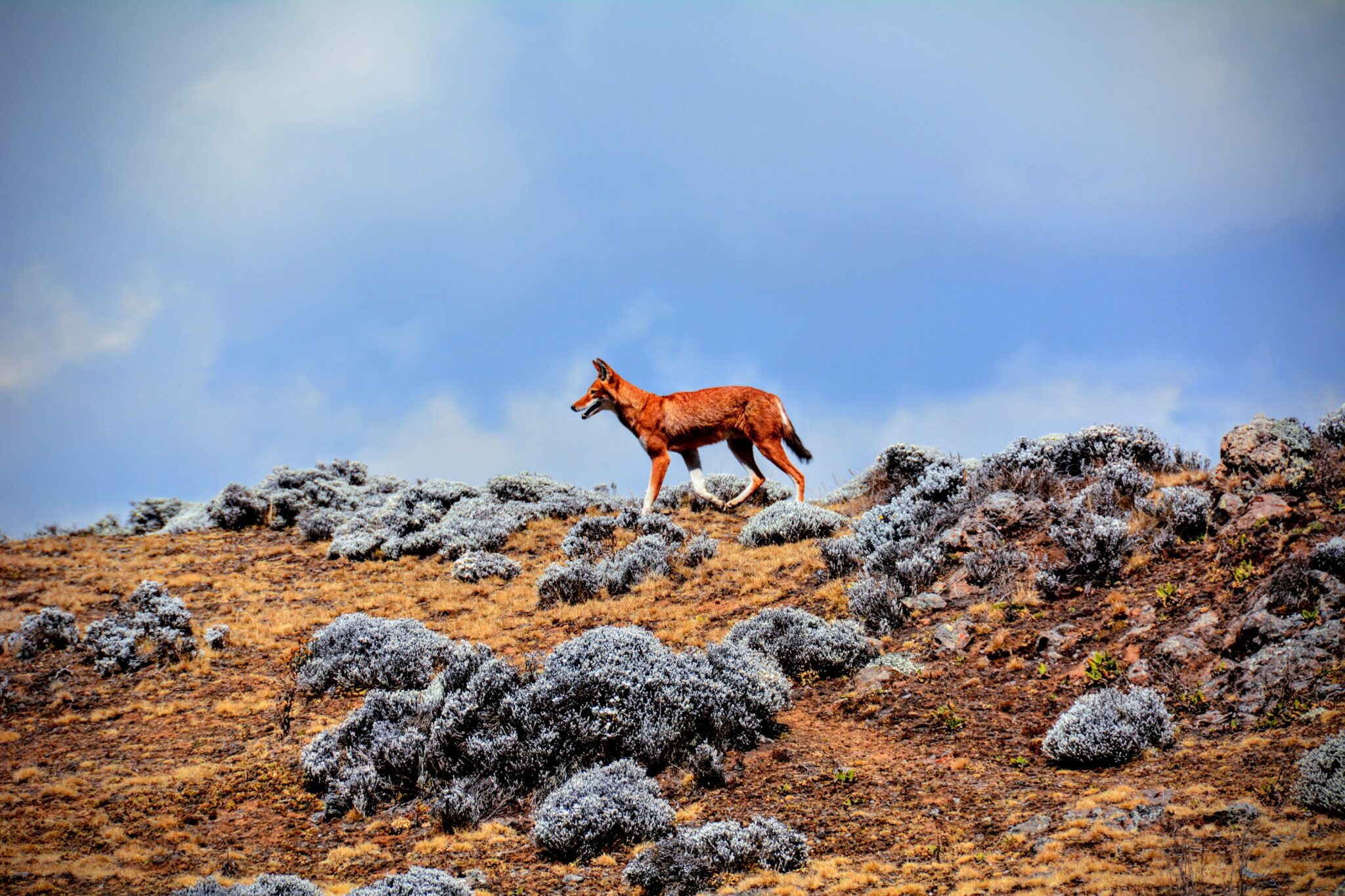
Bale Mountains National Park is one of Ethiopia’s best places for Afro-alpine landscapes: wide, open high plateaus, cold moorlands, and deep valleys that feel very different from the Northern Circuit. The Sanetti Plateau is the signature environment, sitting at roughly 3,800 to 4,300 m, where short hikes and slow drives give you huge skies, stark vegetation, and a real sense of altitude. If you have a specialist wildlife interest, Bale is also the country’s standout area for endemics, including the Ethiopian wolf, while the lower zones around Harenna Forest shift into thick woodland and a more humid, green ecosystem. Temperature swings are significant here, with warm sun in the day and very cold nights at altitude, so layered clothing is essential even when travelling in the dry season.
Most itineraries base around Dinsho, the practical gateway for walking and for arranging park logistics, or combine Dinsho with a higher-altitude overnight closer to the plateau to maximise early-morning time. The best routine is to start activities early for clearer visibility and higher chances of wildlife movement, then plan for clouds, wind, and occasional light rain building later in the day, especially on the plateau. From Addis Ababa, travellers usually route via the Rift Valley road toward the Bale area, often breaking the journey with a stop in towns such as Shashamane or Dodola depending on your plan; from larger hubs like Robe you can typically reach Dinsho in about an hour by road.
Danakil Depression (Afar)
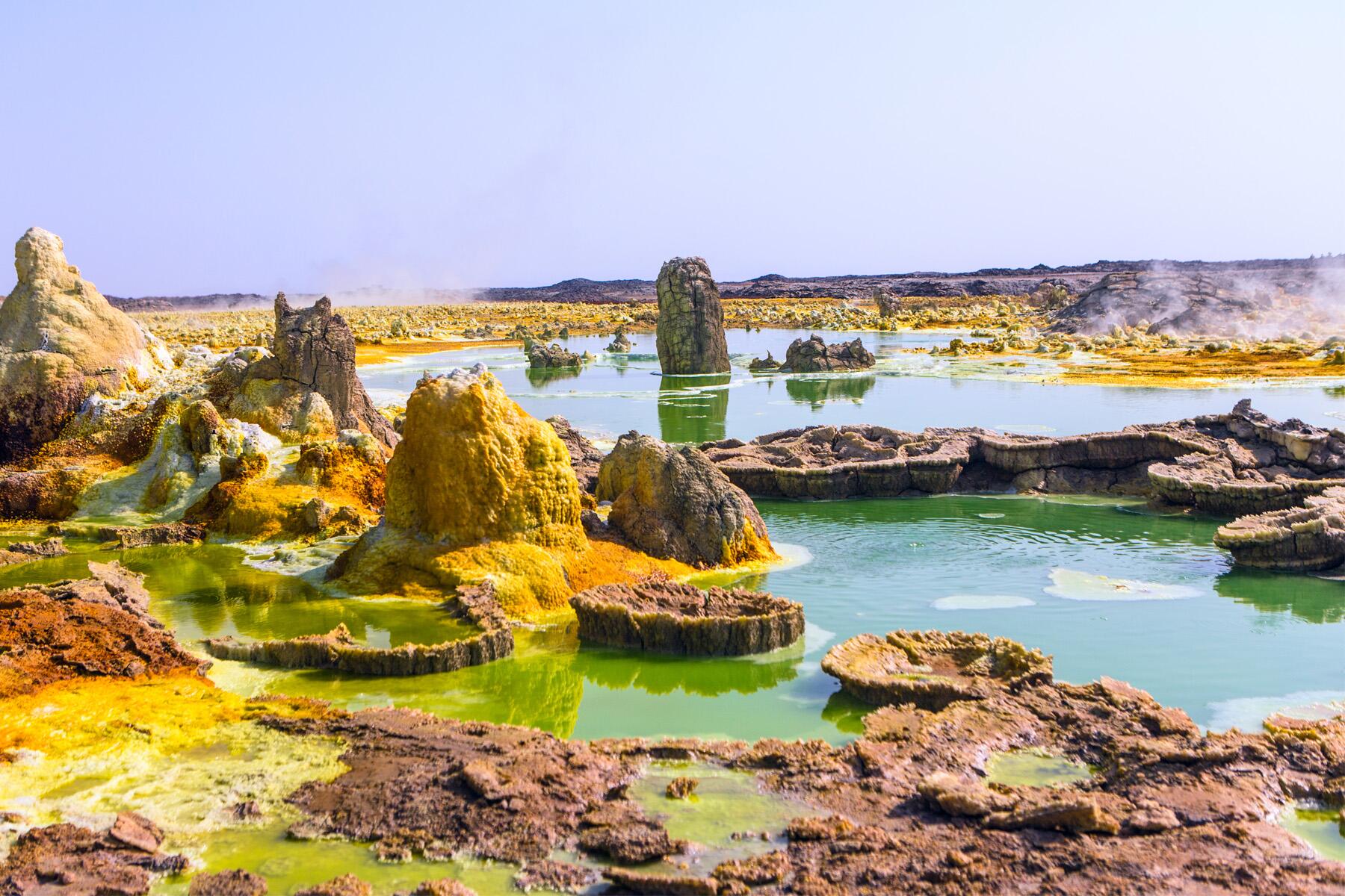
The Danakil Depression in the Afar region is one of the planet’s most extreme landscapes, sitting well below sea level in places and combining salt flats, sulphur-coloured geothermal fields, and active volcanic terrain in a single expedition-style corridor. Many visits focus on three headline environments: the vast salt plain around Dallol, where mineral deposits create vivid yellow, green, and white formations; the salt caravans and extraction areas near the Afar communities, where blocks are still cut and moved in traditional ways; and the Erta Ale volcanic zone, where treks and overnight camps are often planned so you can reach viewpoints in cooler hours. Heat is the defining factor. Daytime temperatures in the low season can still feel punishing, while in hotter months they can climb well above 40°C, and the combination of sun exposure, wind, and salt glare makes the effort feel harder than the distances suggest.
For most travellers, Danakil is not a place to plan independently. The standard approach is a guided multi-day trip using 4×4 convoys with pre-arranged permits, local coordination, and a fixed water and fuel plan, usually starting from Mekelle in Tigray or Semera in Afar depending on the route and current access conditions. Days are long and often start before sunrise, with several hours of driving between sites and short, intense walking segments at the hottest points, so expectations should be set around endurance rather than comfort. Plan recovery time afterwards, ideally at least a full day in a cooler highland city, because even experienced travellers can feel depleted after consecutive days of heat, early starts, and limited sleep.
Erta Ale Volcano (Afar)
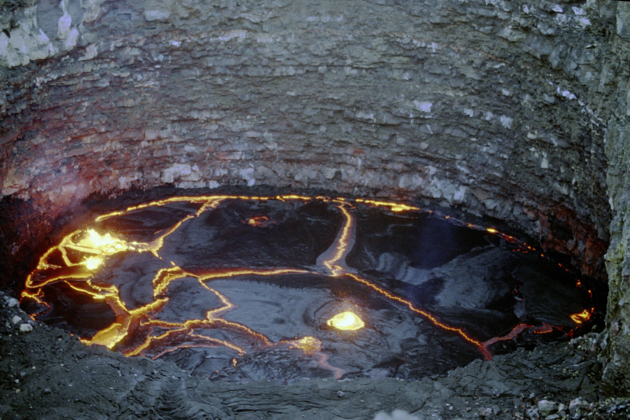
Erta Ale is a shield volcano in Ethiopia’s Afar region and one of the most striking geology-focused additions to a Danakil-style itinerary because the experience is about stark lava landscapes, basalt fields, and a summit area that can feel almost lunar. The appeal is not a single viewpoint, but the sense of scale and raw terrain: you cross hot, dusty ground with little shade, then reach higher, wind-exposed areas where the temperature can drop sharply once the sun is down. Many itineraries time the summit approach for late afternoon or night to reduce heat stress and to improve visibility of glowing activity when conditions allow, but this element is never guaranteed. Volcanic behaviour changes, and even when access is possible, the “best” visual moments depend on weather, wind, and current crater conditions.
In practice, Erta Ale should be treated as optional, not as a promised highlight. Access and feasibility can change due to security, road conditions, and local permissions, and the trip requires a competent operator, reliable vehicles, and a conservative plan for water, fuel, and timing. Most visitors reach the area as part of a guided multi-day Danakil route, typically starting from Mekelle or Semera depending on the route and current access, then driving long distances over rough tracks and camping near the volcano before a final hike that is usually several hours each way at a steady pace.
Awash National Park
Awash National Park is a practical, relatively accessible nature stop on the Addis Ababa corridor, best for classic acacia and savannah scenery, wide skies, and riverine pockets that break up the drive east toward Harar or Djibouti. The landscape highlight is the Awash River gorge and falls area, where dark basalt cliffs and greener river edges create a strong contrast with the surrounding dry plains. Wildlife tends to be a supporting feature rather than a headline safari, but you can often see common plains species such as oryx, gazelles, warthogs, and troops of baboons, with birdlife usually one of the strongest reasons to visit. Expect heat for much of the year, with daytime temperatures often reaching the mid 30s°C in warmer months, so a slow pace, early starts, and serious sun protection make a noticeable difference.
The easiest way to visit is as a 1 to 2 night stop with a morning and late-afternoon game drive, because those cooler windows are when animals are more active and visibility is better. From Addis Ababa, the park is roughly 200 to 230 km depending on your entry point, commonly 3 to 4 hours by road via the main highway, so it works as a long day trip but feels far less rushed with an overnight. Many travellers pair it with nearby hot-spring areas in the broader Awash valley, or use it as a break on the way to Dire Dawa and Harar.
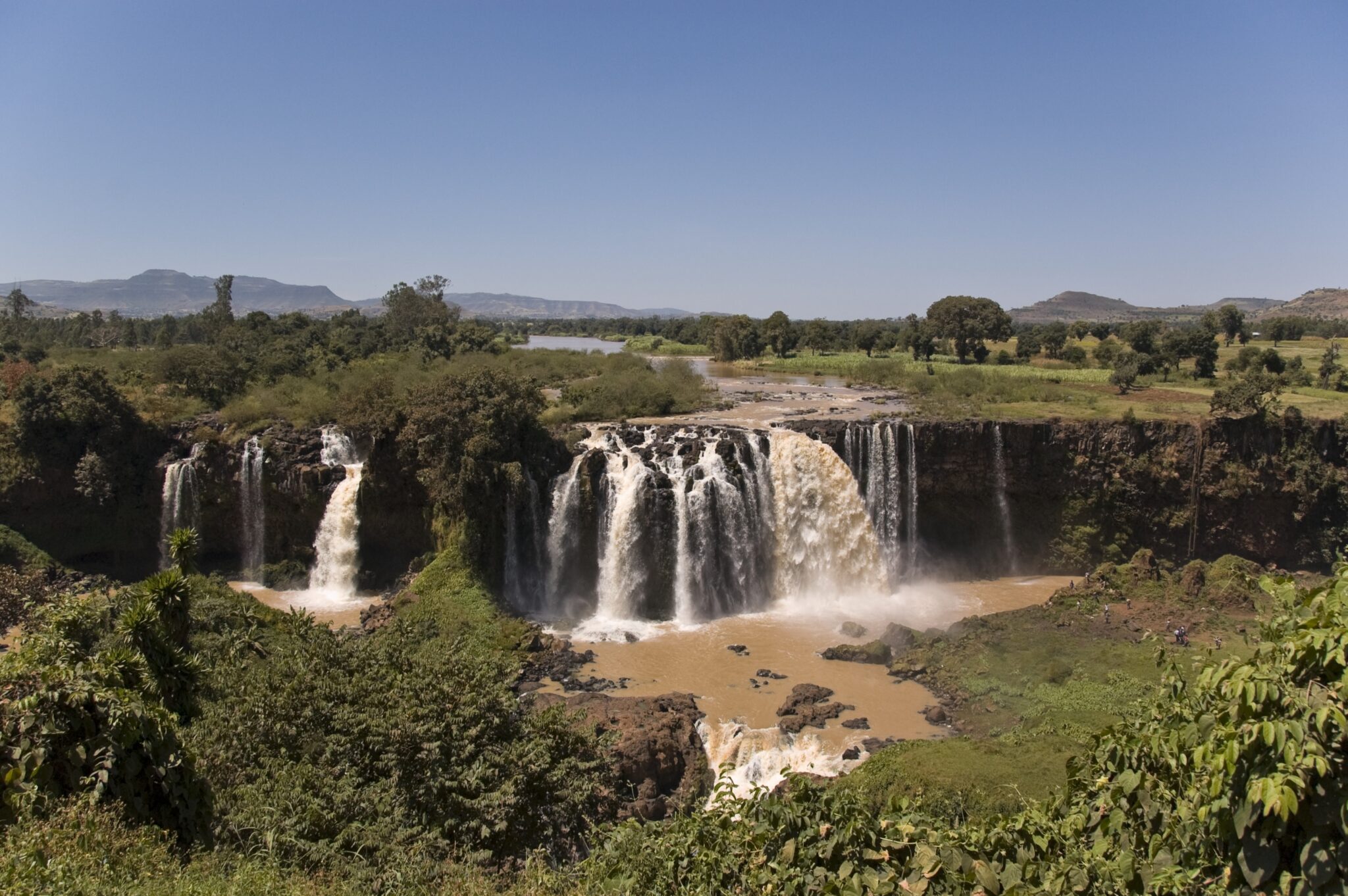
Lake Tana and Blue Nile landscapes
Lake Tana, Ethiopia’s largest lake, spreads across roughly 3,000 to 3,600 square kilometres depending on seasonal levels and feeds the Blue Nile, so the whole area has a water-dominated feel that is rare elsewhere in the country. From Bahir Dar, early-morning boat trips are the most rewarding: the lake is usually calmer, light is softer for photography, and you can combine shoreline scenery with select island or peninsula stops without turning the day into a rush. Even if you are not focusing on monasteries, the appeal is the rhythm of the lake itself: papyrus edges, fishing boats, wide open horizons, and a sense of space that contrasts with Ethiopia’s highland towns. For viewpoints, the lakefront and higher ground around Bahir Dar are best just after sunrise, when haze is lower and the water surface reads as a clean, reflective plane rather than midday glare.
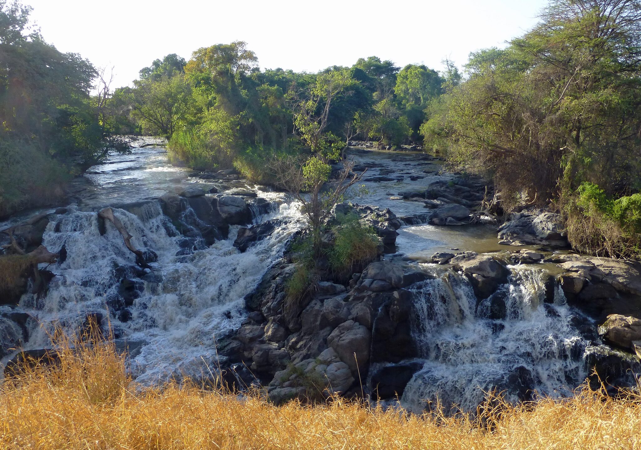
For Blue Nile landscapes, the classic nature segment is the Blue Nile Falls area, often reached as a half-day or full-day excursion from Bahir Dar, with a drive that is commonly around 30 to 40 km each way depending on your exact route, followed by short walks to viewpoints. The falls are most impressive in and just after the rainy season, when flow is higher, while in the drier months the scene can be more about the gorge, basalt formations, and the surrounding countryside than raw water volume. If you want a balanced day, start with the water first, then move to the falls and countryside drives later, because afternoon winds and cloud build-up can make lake crossings rougher and views less crisp. In practical terms, Bahir Dar is the simplest base for everything, and most travellers can cover a satisfying mix of lake scenery, river landscapes, and rural viewpoints in 1 to 2 days without feeling over-scheduled.
Hidden Gems in Ethiopia
Tigray rock-hewn churches (clustered sites)
The rock-hewn churches of Tigray are most memorable because the setting is as important as the architecture: sheer sandstone towers, narrow ledges, and hidden sanctuaries cut into cliff faces, often hundreds of metres above the valley floor. Many of the best-known sites sit in the Gheralta area, west of Wukro, where routes combine short but steep hikes with sections that can feel exposed, so these are visits you treat like a half-day trek rather than a quick stop. Churches such as Abune Yemata Guh are often reached after a 30 to 60 minute ascent plus careful scrambling near the top, while places like Maryam Korkor and Daniel Korkor usually involve a longer climb and are commonly paired as a full outing. Inside, expect compact rock-cut interiors with painted iconography and carved features that can date back many centuries, and outside, expect panoramic viewpoints that are among the most dramatic in northern Ethiopia. Go early in the morning for cooler temperatures, better visibility, and safer footing on steep paths, and assume that a single church visit can take 2 to 4 hours once you include driving, hiking, and time on site.
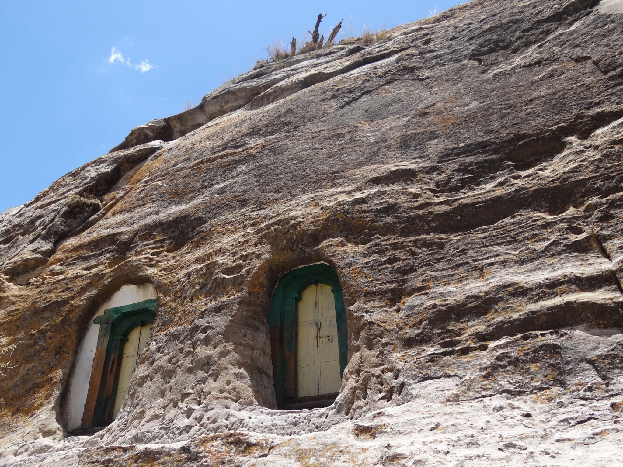
Debre Damo Monastery
Debre Damo is one of Tigray’s most unusual monastic sites because it sits on top of a flat-topped amba, essentially a sheer-sided rock plateau rising above the surrounding landscape. The monastery is traditionally associated with early Ethiopian Christianity, and its appeal is a mix of history, isolation, and the feeling of being in a place that has stayed deliberately apart from ordinary travel circuits. Visits are governed by strict local rules, including long-standing access restrictions that are enforced by the monastic community, so it is essential to treat the site as a living religious institution rather than a tourist attraction. If you are eligible to enter and you are invited to do so under the correct arrangements, the experience can add a rare dimension to a northern itinerary because it is as much about cultural context and protocol as it is about views or architecture.
In practical terms, Debre Damo is usually reached via the Wukro area, then onward by road to the nearest approach point, followed by a short hike and a final cliff ascent using a rope that is roughly 15 metres in vertical climb. The rope section is the defining logistical and safety factor: it is not technical climbing in the mountaineering sense, but it is physical, exposed, and highly dependent on calm conditions, good footing, and experienced local assistance.
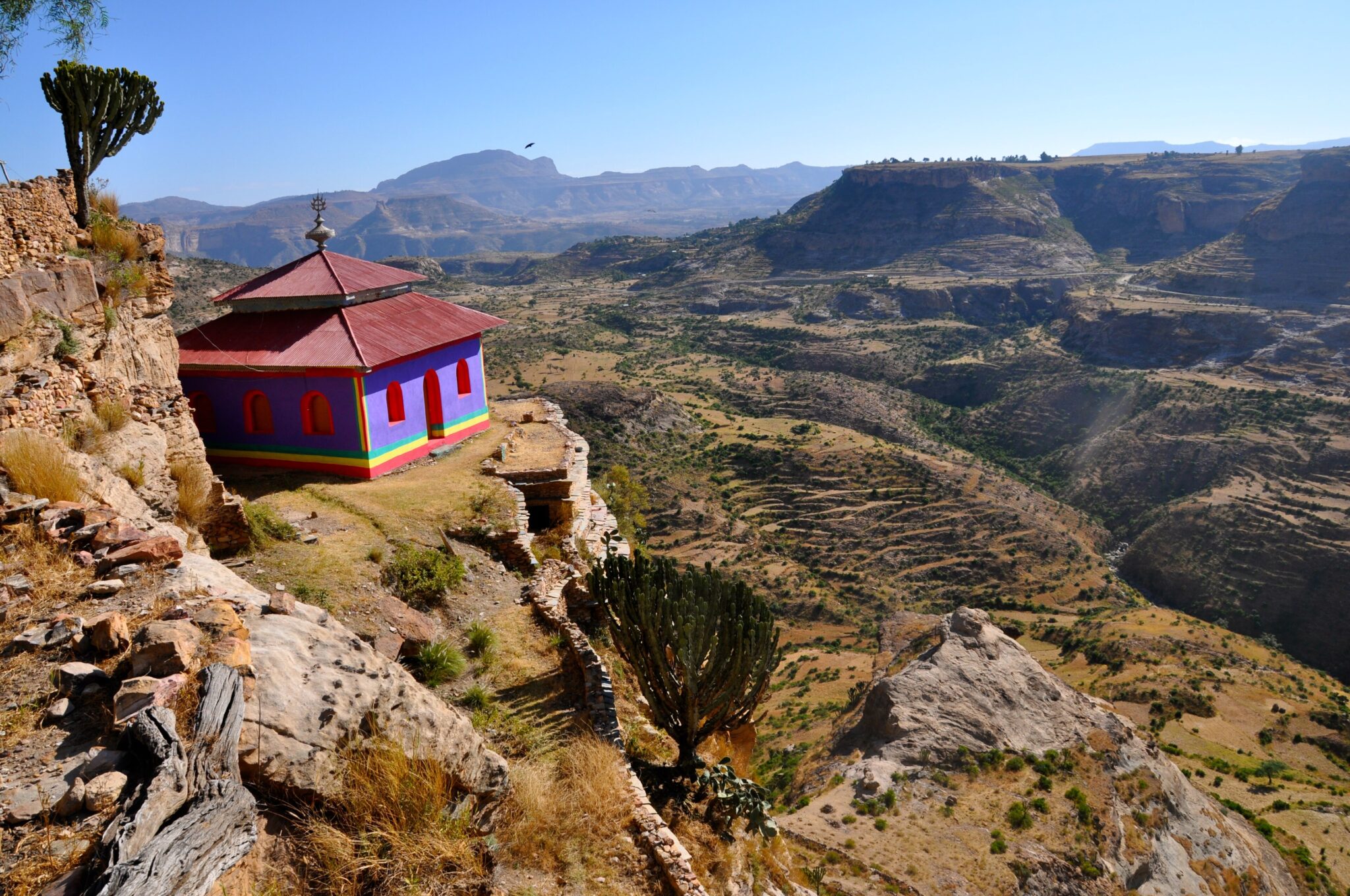
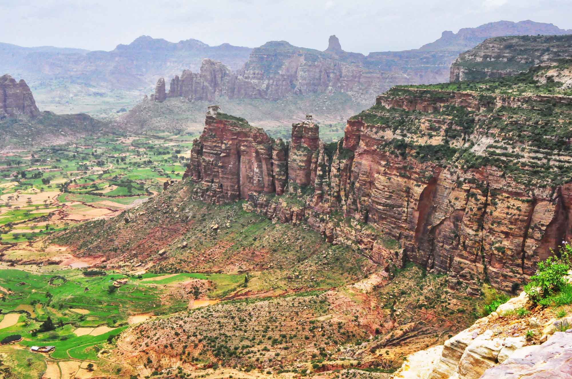
Gheralta Mountains
The Gheralta Mountains are one of northern Ethiopia’s most visually dramatic landscapes, defined by towering sandstone spires, flat-topped mesas, and cliff walls that glow red-gold in early light. The region’s signature experience is combining hiking with heritage: many of the rock-hewn and cliffside churches are embedded directly into the sandstone, so a visit naturally becomes a walk through big scenery with a cultural payoff at the end. Even short routes can feel adventurous because trails often climb quickly from the valley floor to ledges and viewpoints, and the best moments are frequently outside the churches, looking across a vast grid of ridges and isolated rock towers. For photography, the first hours after sunrise are the most rewarding, both for cooler temperatures and for the way low-angle light brings out texture in the rock faces.
Most travellers base in Wukro or in simple lodges within the Gheralta area, then drive to individual trailheads for half-day and full-day outings. Typical hikes involve 1 to 4 hours of walking depending on the site, plus time on steep sections, and it is common to group nearby churches and viewpoints into a single day rather than bouncing between distant valleys. Carry more water than you think you need, as shade can be limited and the dry air at altitude dehydrates quickly, and wear footwear with strong grip because sandy rock and loose gravel are common on the approach paths.
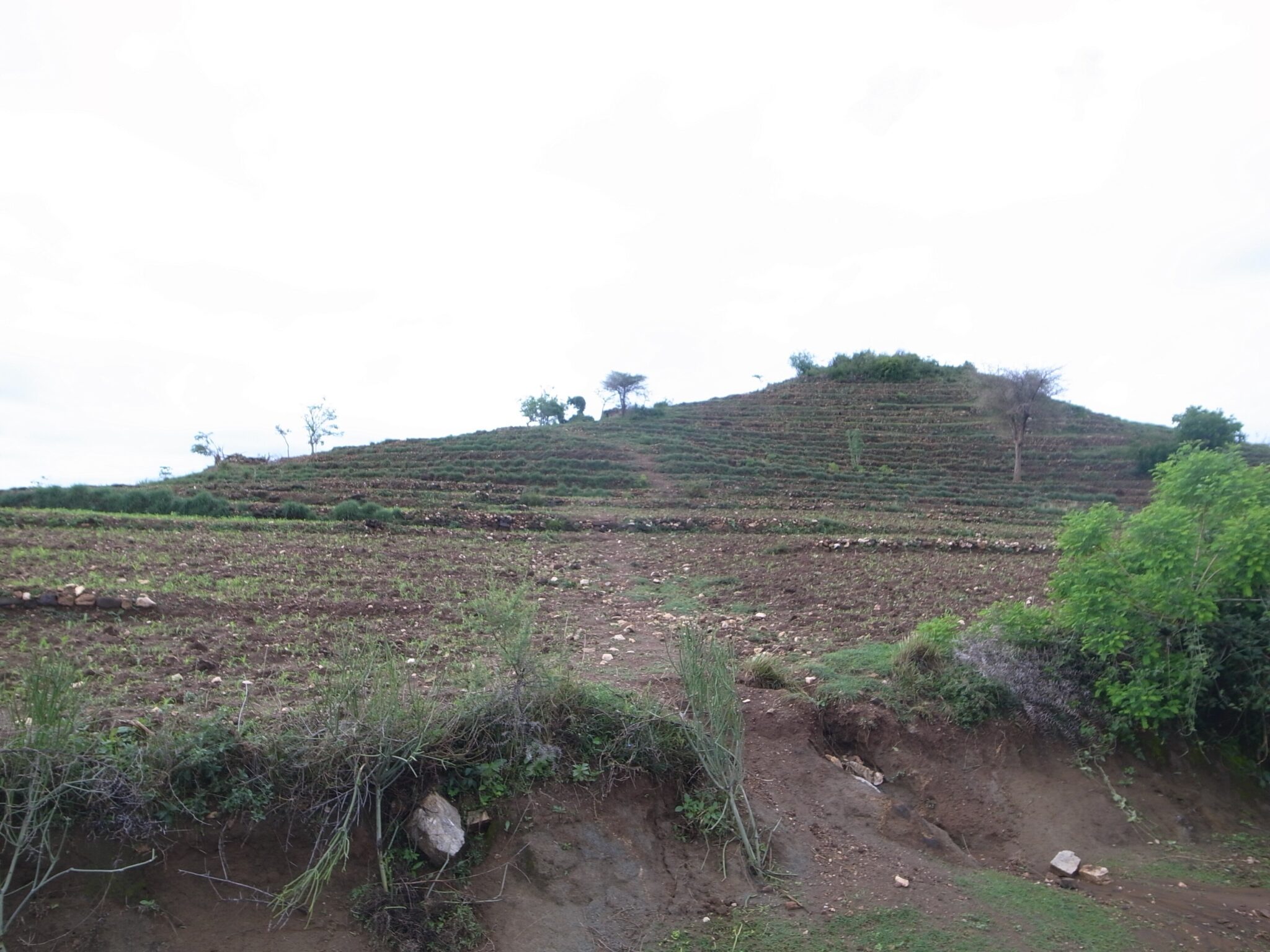
Konso Cultural Landscape
Konso Cultural Landscape in southern Ethiopia is a UNESCO-listed area where heritage is expressed through lived-in terrain: stone terraces that stabilise hillsides, manage water, and support farming across steep slopes, alongside fortified hilltop settlements known locally as walled villages. The most rewarding visit focuses on how the landscape functions rather than on a single monument. With a knowledgeable local guide, you can walk terrace paths, see communal meeting spaces, and understand how stonework, soil management, and tree cover are maintained across generations. Many itineraries also include carved wooden grave markers and commemorative figures, plus craft traditions such as weaving and woodworking, but the real impact comes from seeing a cultural system that is visible in every field boundary and ridge line.
Konso is easiest to visit as an overnight stop so you have time for a guided walk plus a village visit without rushing the daylight. The usual approach is by road from Arba Minch, roughly 90 km and often around 2 to 3 hours depending on road conditions and traffic, making it feasible as a long day trip but better with a night in the area. From Jinka, it is commonly around 200 km and often 4 to 6 hours by road, so Konso also works well as a break when moving between the Omo Valley circuit and the lakes around Arba Minch. From Addis Ababa, most travellers fly to Arba Minch and continue by car, or plan a multi-day overland route.
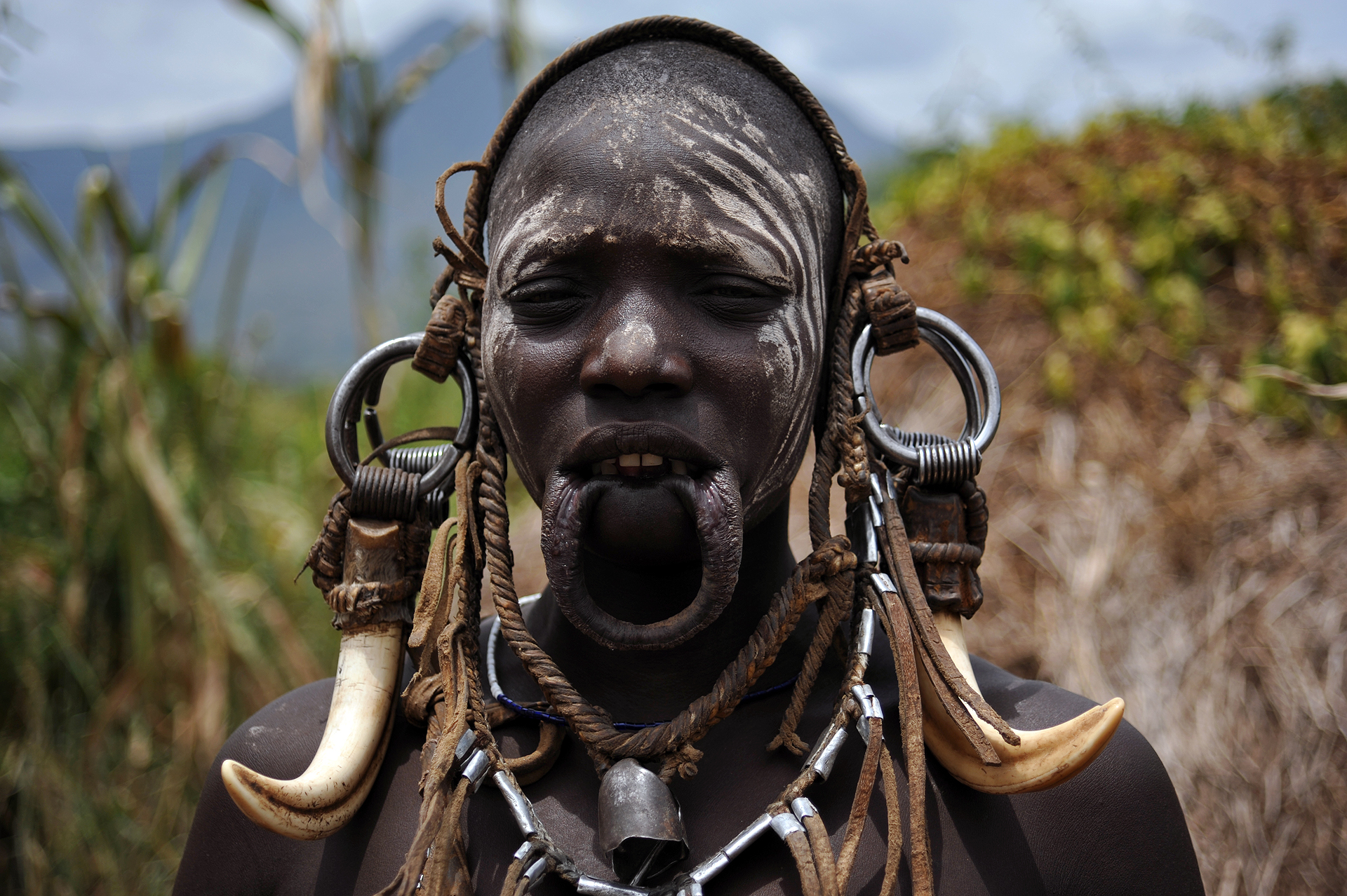
Omo Valley cultural route
The Omo Valley is best treated as a culture-first route where the main “sight” is living community life rather than attractions, and that brings ethical responsibilities that are central to the experience. A responsible visit is typically selective: you choose a small number of communities and spend longer learning context rather than rushing through multiple villages in a single day. The most meaningful itineraries prioritise informed consent, fair payment arranged transparently through local structures, and behaviour that does not pressure people into performances. Keep expectations grounded: daily life does not run on a tourist schedule, some visits may be declined, and your guide’s relationship with the area matters more than a packed list of stops. Photography should be treated as optional, not default, with permission asked clearly and refusal accepted without discussion; many travellers find the trip improves when they focus on conversation, craft traditions, markets, and landscape rather than trying to “collect” images.
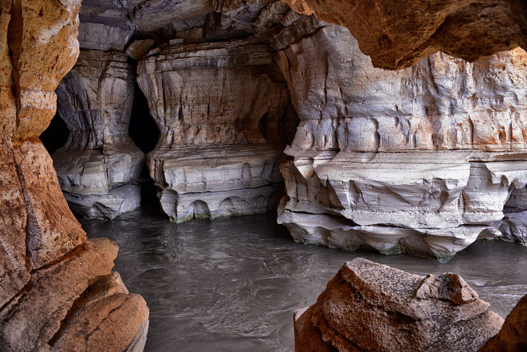
Sof Omar Caves
Sof Omar Caves are one of Ethiopia’s most distinctive geology stops: a large limestone cave system carved by the Weyib River, with long, cathedral-like chambers, natural arches, and dark tunnels where you can clearly feel the scale of underground water erosion. The experience is less about a polished visitor site and more about atmosphere and terrain, so it suits travellers who enjoy unusual landscapes and do not mind rough edges. Conditions can change with season and local maintenance, and sections may be slippery or uneven, especially near water-worn rock, so good grip footwear matters. Bring a reliable light source even if you expect basic lighting, and plan to move slowly; with a guide, you are far more likely to see the most interesting formations while avoiding the less stable or confusing sections.
Most visitors reach Sof Omar as a day trip or overnight add-on when travelling through the Bale area. A common approach is from Robe or Goba, with a drive that is often around 2 to 4 hours each way depending on road conditions and the exact route, so an early start is important if you want time inside the caves without rushing back before dark. From Dinsho and the Bale Mountains gateway zone, the transfer is longer and usually treated as a full-day outing. Ask locally about the most suitable time to visit because river flow can affect both access and comfort, and aim to avoid arriving late in the day since the caves are inherently low-light and navigation is easier when you are not trying to beat sunset on the return.
Travel Tips for Ethiopia
Safety and General Advice
Ethiopia is a rewarding destination for cultural, historical, and natural exploration, but careful planning is essential. Conditions can vary by region, and travel advisories should be checked regularly. Working with reputable local operators and using up-to-date local guidance will make travel safer and smoother. In urban areas, basic awareness goes a long way — keep valuables discreet, stay alert in crowded markets, and use trusted transport after dark. For remote travel, allow extra time in your schedule for potential road delays or route changes, as terrain and weather can be unpredictable.
Comprehensive travel insurance is strongly recommended, covering medical care, emergency evacuation, and any trip interruptions. Before departure, consult a travel clinic for advice on vaccinations and malaria prevention tailored to your specific itinerary. Bottled or filtered water should be used for drinking, and it’s helpful to carry electrolytes or hydration tablets when visiting hotter or higher-altitude regions. Good preparation ensures comfort across Ethiopia’s wide range of climates and landscapes.
Driving in Ethiopia
Drivers must carry their national license, an International Driving Permit, and passport or official ID at all times. Keep rental and insurance documents readily accessible for roadside checks, which are routine but generally straightforward when papers are in order. Self-driving in Ethiopia can be challenging due to variable road conditions, long distances, and navigation difficulties, so many travelers prefer to hire a car with a driver for intercity routes. Those who choose to drive themselves should select a reliable vehicle with high clearance, plan realistic daily distances, and ensure regular fuel stops. Road conditions range from paved highways to rough gravel tracks, and travel can be slow in rural areas. Night driving outside major towns is best avoided because of limited lighting, livestock, and unpredictable road users.
Published February 08, 2026 • 23m to read