Central African Republic is one of the least-explored countries on the continent, defined by large areas of wilderness and very limited tourism development. Much of the country is covered by rainforests, savannahs, and river systems that support a high level of biodiversity, including species rarely seen elsewhere. Human settlement is sparse outside a few urban centers, and many regions remain difficult to access.
Travel in the Central African Republic requires careful planning, reliable local knowledge, and constant attention to current conditions. For those able to travel responsibly, the country offers access to remote national parks, forest landscapes, and communities whose ways of life are closely tied to their environment. It is a destination focused on nature, isolation, and cultural depth rather than conventional sightseeing, appealing only to highly experienced travelers.
Best Cities of the CAR
Bangui
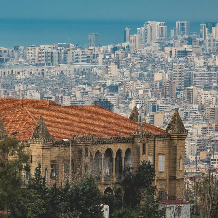
Bangui is the Central African Republic’s capital and largest city, positioned on the north bank of the Ubangi River, directly opposite the Democratic Republic of the Congo. The city lies close to 4.37°N, 18.58°E at roughly 370 m above sea level, and population estimates for the urban area are commonly in the high hundreds of thousands (figures vary by source and year). The riverfront is central to understanding Bangui: along the busiest landing points you can watch how small-scale shipping, fishing, and market supply work on a major waterway, with pirogues and cargo boats moving people, food, and household goods. For a quick, high-impact introduction, walk the central market area and nearby streets in the morning when deliveries peak, then continue toward the waterfront to see how river transport and informal trade knit the city together.
For cultural context, the National Museum and the Boganda Museum are the most practical stops because they outline key historical periods, political milestones, and the country’s ethnic diversity in a way that helps you “read” other regions later. A simple add-on is a short river crossing to the Congo-side town of Zongo, or a boat ride for island-side views, not as a classic attraction but as a lesson in geography and daily mobility. Most arrivals are via Bangui M’Poko International Airport (IATA: BGF), about 7 km northwest of the center, with a main paved runway of roughly 2.6 km that can handle medium to large jets. Overland, the primary corridor is the RN3 toward Cameroon: Bangui to Berbérati is about 437 km (often 11 to 12+ hours by road in good conditions), and Bangui to Bouar is roughly 430 to 450 km depending on route and road state. Travel times can expand significantly in the rainy season, so planning fuel, daylight driving, and reliable transport is as important here as the sightseeing itself.
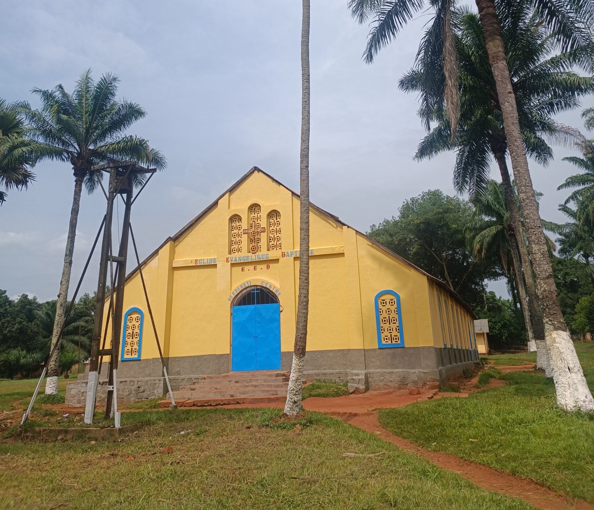
Berbérati
Berbérati is one of the largest cities in the Central African Republic and the capital of Mambéré-Kadéï Prefecture, set in the southwest near the Cameroon border. The urban area covers roughly 67 km², sits at about 589 m elevation, and is often cited at around 105,000 residents. It is an important commercial and supply hub for the region, so the best “in-town” experience is practical and everyday: spend time in the main markets and the busiest road junctions where produce, household goods, and transport logistics concentrate. This is where you will see how the city functions as a trading center, with constant movement of people, minibuses, and goods.
As a base, Berbérati is useful for short trips into the surrounding countryside, where landscapes quickly turn greener and more rural, and for staging travel deeper toward forested areas farther south. Most travelers arrive overland: from Bangui it is about 437 km by road (often roughly 11–12 hours in good conditions, but longer in the rainy season), while Carnot is about 93–94 km away and Bouar roughly 235–251 km depending on the route. The city also has an airport (IATA: BBT) about 2 km south of town with an asphalt runway of around 1,510 m, but services can be irregular, so shared taxis and hired vehicles, ideally a 4×4 for rougher stretches, are typically the most reliable way to get in and out.
Bambari
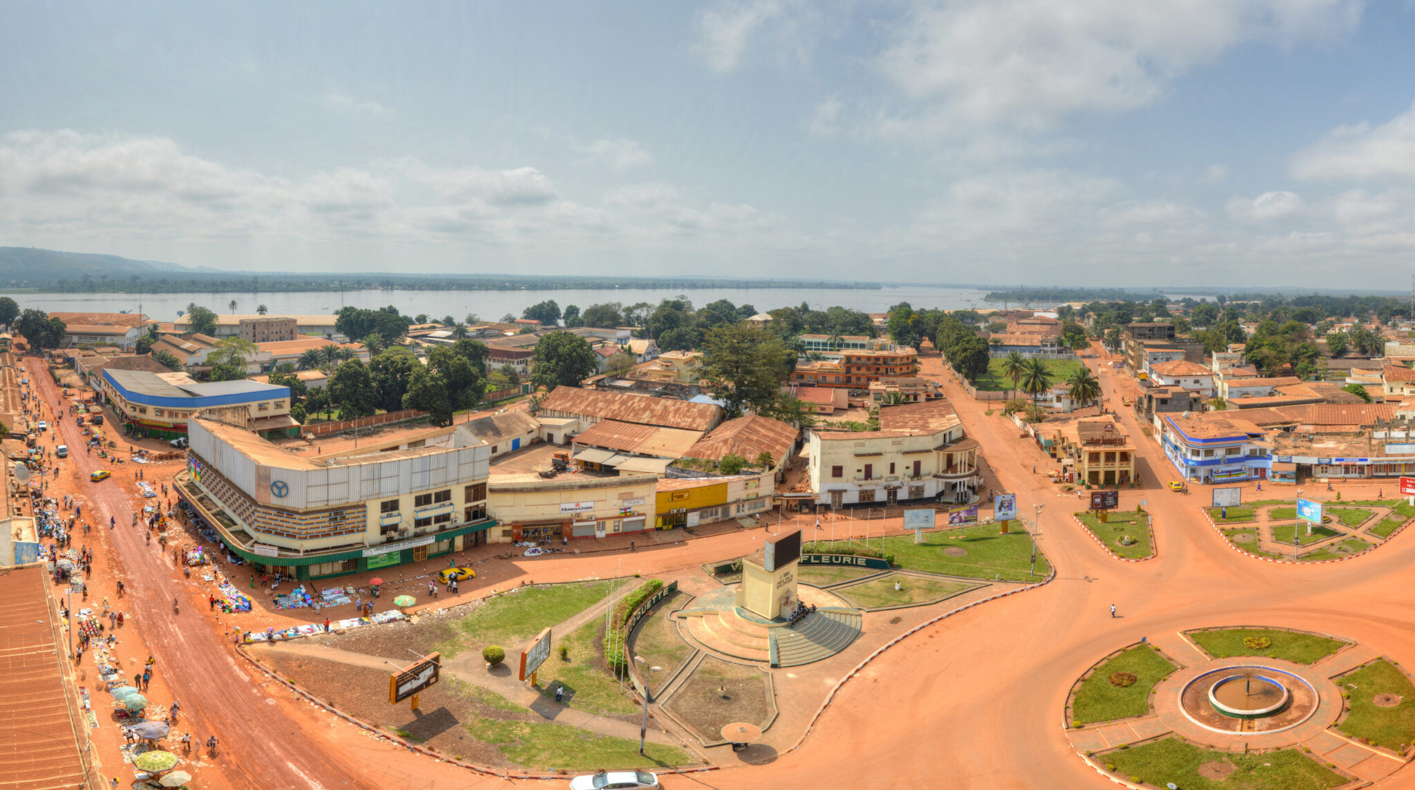
Bambari is a central town in the Central African Republic and the capital of Ouaka Prefecture, set along the Ouaka River, which makes it naturally important for movement of people and goods between river communities and the surrounding savannah. The town’s population has been reported at roughly 41,000 in early 2010s figures, and it sits at about 465 m above sea level. It is not a “tourism city” in the classic sense, but it is a strong place to understand how an inland hub works: spend time around the main market corridors and the riverbank to see how staples and everyday supplies arrive from nearby villages, then move onward by road. Because Bambari is an administrative and trading center, it tends to have more basic services than smaller settlements in the Ouaka region, even if comfort-oriented infrastructure remains limited.
Most travelers reach Bambari overland from Bangui. Road distance is commonly cited in the 375–390 km range depending on the route, and in practice you should plan for a long, full-day drive because travel times can swing widely with road conditions and the season.
Best Natural Wonders and Wildlife Sites
Dzanga-Sangha Special Reserve
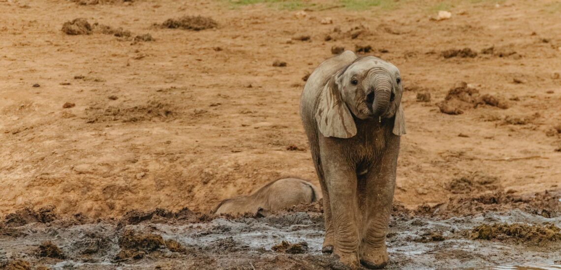
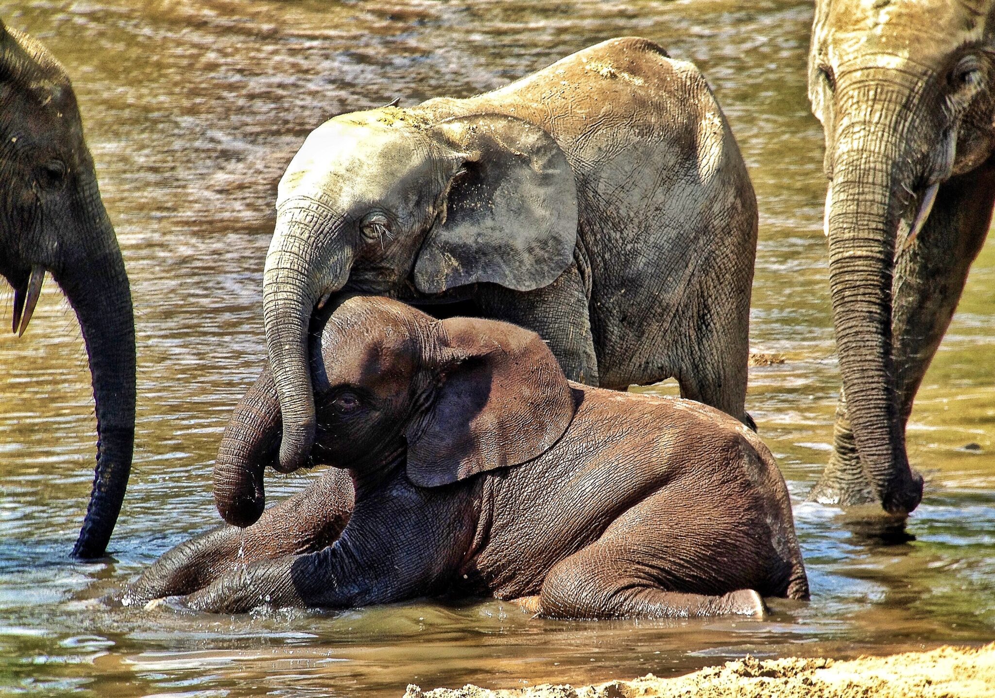
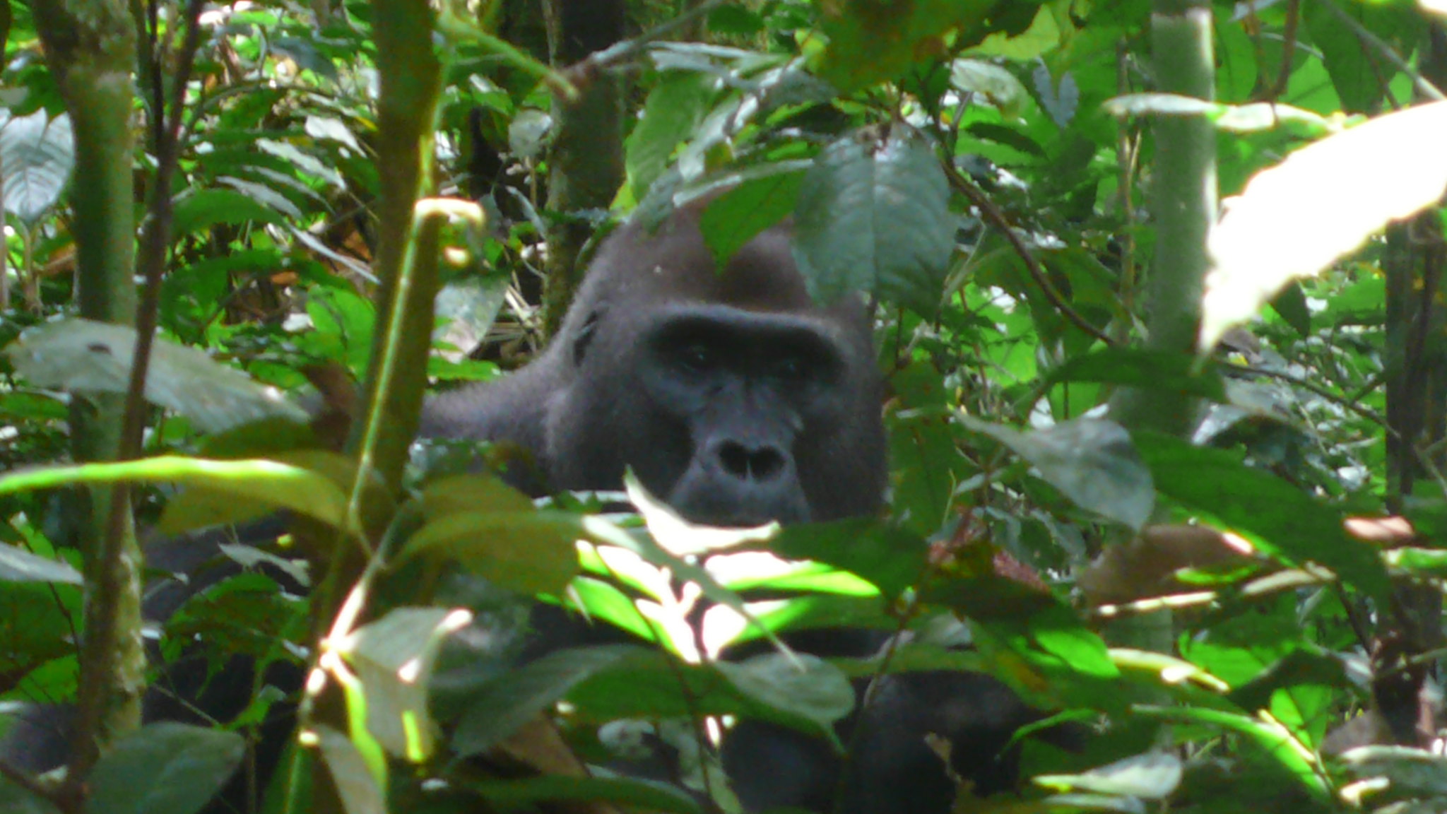
Dzanga-Sangha Special Reserve is the Central African Republic’s premier rainforest conservation area and one of the most significant protected landscapes in the Congo Basin. Established in 1990, the wider Dzanga-Sangha protected-area complex includes a multi-use dense forest reserve of about 3,159 km² and the strictly protected Dzanga-Ndoki National Park, which is split into two sectors of roughly 495 km² (Dzanga) and 727 km² (Ndoki). In the broader transboundary context, it sits within the Sangha Trinational UNESCO World Heritage site, a three-country conservation block with a legally defined area of about 746,309 hectares (7,463 km²). What makes Dzanga-Sangha exceptional for visitors is the quality of guided viewing: at Dzanga Bai, a mineral-rich forest clearing, long-term monitoring shows that roughly 40 to 100 forest elephants can be present in the clearing at a time, and research over two decades identified more than 3,000 individual elephants, which is unusually strong for rainforest wildlife observation.
Access is typically organized via Bayanga, the gateway settlement where most eco-lodges and guiding teams are based, and activities are managed with permits and strict rules. From Bangui, overland travel to Bayanga is commonly described as about 500 to 520 km and can take around 12 to 15 hours, with only about 107 km paved, so a hired 4×4 and careful planning for fuel and conditions are standard. Charter flights are sometimes used to shorten the journey, but schedules are not reliably regular, so most itineraries treat flying as an option rather than a guarantee. Once in Bayanga, elephant viewing at Dzanga Bai is usually done from a raised platform with several hours of quiet observation, while gorilla tracking focuses on habituated western lowland gorilla groups in designated zones, with time near the animals typically limited (often around 1 hour) to reduce stress and disease risk; chimpanzees and a high diversity of birds add to the experience for those who stay longer.
Dzanga Bai
Dzanga Bai is an open forest clearing inside the Dzanga sector of the Dzanga-Sangha complex, and it is famous because it turns dense rainforest into a place where wildlife can be watched clearly for hours. The bai is a mineral-rich “meeting point” that attracts animals to drink and feed on nutrient-heavy soils, which is why forest elephants, normally hard to spot in thick vegetation, can be observed in large numbers at close range. A raised viewing platform is positioned to overlook the clearing, allowing long, stable observation without disturbing the animals, and it is common to spend several hours there rather than trying to “catch a quick sighting”. Long-term monitoring in the area has recorded thousands of individual elephants over time, which illustrates how consistently the site draws them.
In practical terms, Dzanga Bai is usually visited as a guided excursion from Bayanga, the reserve’s main gateway settlement. You typically travel by 4×4 on forest tracks, then walk a short distance to the platform; exact time depends on road conditions and season, but plan for a half-day experience including travel, briefing, and observation. The best results come with an early start, quiet behavior on the platform, and patience, because elephant numbers can rise and fall through the day as family groups arrive, interact, and move on. If your schedule allows, adding a second visit improves odds of seeing different groups and behaviors, since herd composition and activity patterns can vary significantly from one day to the next.
Manovo-Gounda St. Floris National Park
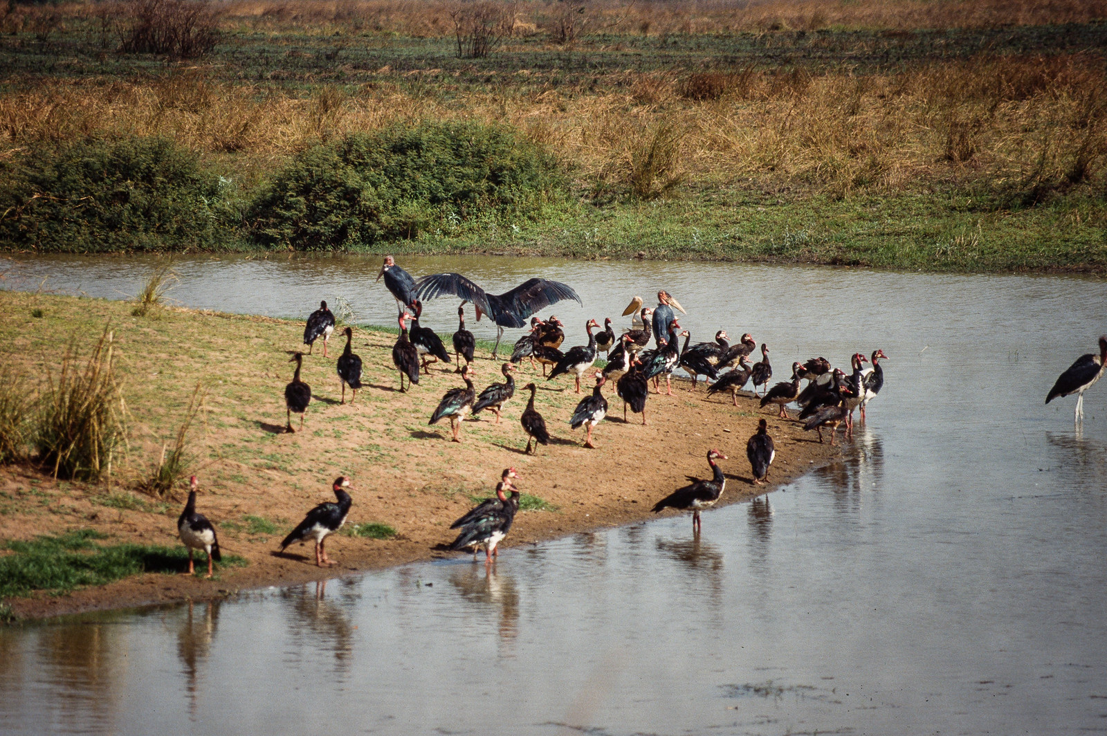
Manovo-Gounda St. Floris National Park is a UNESCO World Heritage Site in northeastern Central African Republic and one of the largest protected savannah landscapes in the region. The park covers about 1,740,000 hectares, which is roughly 17,400 km², and it was inscribed on the World Heritage List in 1988. Ecologically, it sits in a transition zone between different Central African savannah types, mixing open grasslands, wooded savannah, seasonal floodplains, wetlands, and river corridors. Historically it was known for big-mammal diversity: elephants, hippopotamuses, buffalo, antelope species, and predators such as lions and cheetahs, plus giraffes in suitable habitats. Birdlife is also a major asset, with around 320 recorded species in the wider landscape, especially where wetlands and floodplains concentrate waterbirds.
This is an extremely remote park with minimal tourism infrastructure, so it is best understood as a “raw wilderness” destination rather than a conventional safari circuit. Most access is routed via northeastern towns such as Ndélé, with overland travel usually requiring a 4×4 and multi-day, weather-dependent driving on rough roads; in practice, logistics and security conditions often determine what is feasible more than distance alone. From Bangui, travelers typically plan either an overland approach toward Ndélé (often cited at roughly 600 km northeast) and then continue toward the park zone, or they investigate regional flights to airstrips when available, followed by vehicle support. If you go, expect a highly organized, expedition-style setup with permits, reliable local operators, extra fuel and supplies, and conservative timing that accounts for slow travel and changing conditions.
Bamingui-Bangoran National Park
Bamingui-Bangoran National Park is one of the Central African Republic’s largest protected savannah landscapes, covering about 11,191 km², with a mix of wooded savannah, broad floodplains, seasonal swamps, and riverine forest. The park is shaped by the Bamingui and Bangoran river systems, which create wet-season wetlands and dry-season water corridors that concentrate wildlife movement. It is particularly strong for birdlife: compiled lists for the wider park complex commonly exceed 370 species, with well over 200 thought to breed locally, making it a high-value site for waterbirds, raptors, and Sahel-savannah species during seasonal migrations. Large mammals can still occur across suitable habitats, but the experience is best approached as remote wilderness and bird-focused exploration rather than a classic, infrastructure-heavy safari.
Visitor numbers remain very low because logistics are demanding and services are minimal. The most practical gateway is Ndélé, the main town of the region; from Bangui to Ndélé the road distance is commonly cited around 684 km, often 18 hours or more in good conditions, and longer when roads deteriorate or travel is slowed by checkpoints and weather.
Best Cultural and Historical Sites
Boganda Memorial (Bangui)
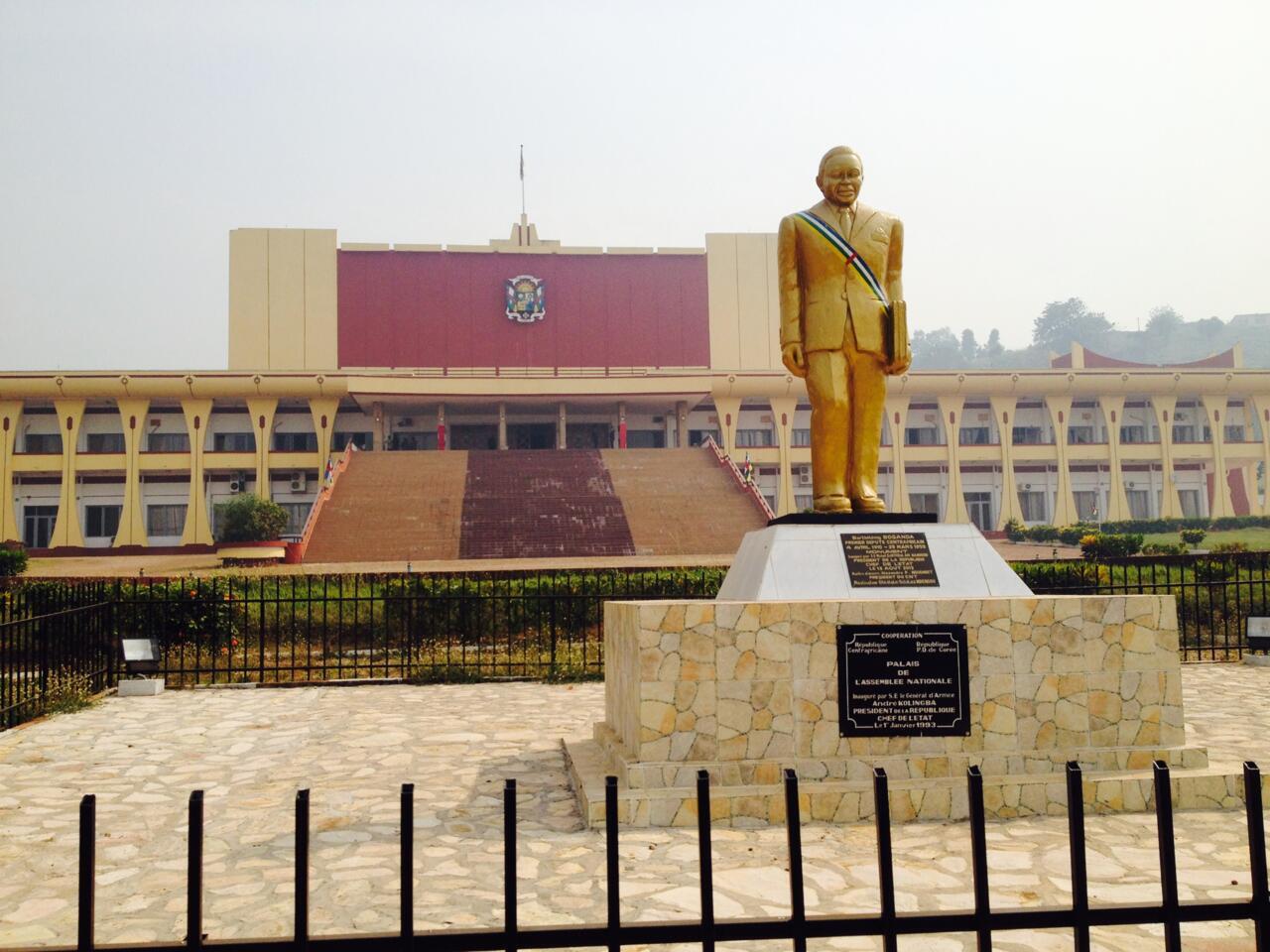
The Boganda Memorial in Bangui is a landmark dedicated to Barthélemy Boganda, the country’s leading independence-era figure and the first prime minister of what was then the Central African Republic within the French Community. It is primarily a symbolic site rather than a “museum-style” attraction, but it matters because it anchors key parts of the national story: the transition away from colonial rule, the rise of modern political identity, and the way Boganda is remembered as a unifying figure. A short visit works best when paired with nearby civic spaces and the broader city center, because it helps you place Bangui’s monuments, ministries, and main arteries in a historical context.
Getting there is straightforward from anywhere in central Bangui: most visitors reach it by taxi or on foot if staying near the core districts, typically within 10 to 20 minutes depending on traffic and your starting point. If you are coming from Bangui M’Poko International Airport, plan roughly 7 to 10 km into the center, commonly 20 to 40 minutes by car depending on road and time of day. To make the stop more meaningful, combine it with the central market and a short riverfront walk the same day, as those places show how the capital’s “official” history and everyday life intersect.
National Museum of the Central African Republic
The National Museum of the Central African Republic is one of the most useful stops in Bangui for understanding the country beyond the capital. Its collections focus on ethnographic material such as traditional tools used in farming, hunting, and household life, carved masks and sculptural objects, and a strong set of musical instruments that reflect how ceremonies and community life vary across regions. The value of the museum is contextual: even a short visit helps you recognize recurring materials and forms you may see later in markets and villages, and it provides a quick framework for the country’s ethnic diversity and regional cultural differences.
Getting there is easy from central Bangui by taxi or on foot if you are staying nearby, typically within about 10 to 20 minutes inside the city depending on traffic. From Bangui M’Poko International Airport, most routes into the center are roughly 7 to 10 km and commonly take around 20 to 40 minutes by car.
Traditional Gbaya Villages
Traditional Gbaya villages are rural communities where you can still see everyday patterns of life that explain the region better than any “attraction” in town. The experience typically centers on vernacular house forms and village layout, small-scale farming and food processing, and practical crafts such as weaving, carving, and tool-making that are closely tied to local materials. A visit is most meaningful when it focuses on daily routines rather than staged performances: how fields are worked, how harvest is stored, how water and firewood are managed, and how household items are made and repaired. Because villages differ widely, even within the same area, you will often gain the clearest insight by visiting one community and spending time talking with elders, craft workers, and farmers through a trusted local interpreter.
Getting to a Gbaya village depends on where you base yourself, since the Gbaya are concentrated mainly in western and northwestern parts of the country. Practically, travelers usually arrange transport from a nearby town that functions as a hub, often Berbérati or Bouar, using a hired car or motorbike taxi for the last kilometers on laterite roads. Travel times can be short in distance but slow in reality, especially after rain, so it is wise to plan a half-day or full-day outing and return before dark.
Hidden Gems of the CAR
Bayanga
Bayanga is a small settlement in the far southwest of the Central African Republic that functions as the practical gateway to Dzanga-Sangha. Even though it is central to conservation operations and guided wildlife activities, it remains lightly visited because it sits deep in the Congo Basin forest and requires real logistics to reach. In town, the “sightseeing” is mostly about context: you will see how expeditions are organized, how supplies are staged, and how river and road travel shape daily life. The Sangha River is the defining feature, and short boat outings are one of the most rewarding ways to experience the area, with chances to spot riverine birds and to understand how communities move and trade along the water.
Getting to Bayanga is typically done either by a long overland trip or by chartered light aircraft when available. From Bangui, overland distances are commonly described in the 500–520 km range, but travel time is the bigger issue: you should plan around 12–15 hours in good conditions and longer when roads are slow, with long stretches of laterite and forest tracks where a 4×4 is effectively mandatory. Many itineraries route via towns such as Berbérati as a staging point before continuing southwest, then finalize arrangements in Bayanga with local guides and lodges for excursions to Dzanga Bai and gorilla-tracking zones.
Nola
Nola is a remote river town in southwestern Central African Republic and the capital of Sangha-Mbaéré Prefecture. It sits at the confluence of the Kadéï and Mambéré rivers, which merge here to form the Sangha River, a major Congo Basin waterway. The town’s population is commonly reported at about 41,462 (2012 figures) and it lies around 442 m above sea level. Historically, Nola has functioned as a trading and administrative point for the surrounding forest region, with an economy tied to timber supply chains, river transport, and small-scale commerce. For visitors, the appeal is not “attractions” but the setting: riverfront life, canoe traffic, fish landings, and the sense of being on the edge of vast rainforest landscapes.
Reaching Nola is usually an overland trip. From Bangui, the driving distance is often cited at about 421 km, which typically becomes a full-day journey depending on road conditions and season. From Berbérati, it is far closer at roughly 134 km by road, making it one of the most practical nearby staging cities. Nola can also be used as a starting point for river travel: local pirogues and boat hires can take you along the Sangha toward forest communities and onward toward Bayanga, which is roughly 104 km away by road via RN10, where many rainforest expeditions are organized.
Mbari River
The Mbari River is a little-known river system in southeastern Central African Republic, part of the Ubangi Congo drainage. It runs for roughly 450 km before joining the Mbomou River and drains an estimated 23,000 to 24,000 km², cutting across a sparsely populated plateau landscape where large stretches still feel ecologically intact. What you can experience here is “river life” rather than classic sightseeing: fishing villages with canoe landings, floodplain channels that expand in the wet season and shrink into deeper pools in the dry season, and long, quiet sections where birdlife is often the most visible wildlife. Because the area is lightly developed, basic services can be far apart, mobile coverage is unreliable in many sections, and conditions can shift quickly after heavy rain.
Access usually requires local logistics and an expedition mindset. Most routes start from Bangassou, the nearest major town commonly used as a staging point, then continue by 4×4 on laterite roads to river access points, followed by travel by dugout canoe or small motorboat depending on water level. From Bangui to Bangassou, overland travel is typically described at roughly 700 km and often takes at least a full day, sometimes longer, depending on road conditions and season.
Ouaddaï Plains
The Ouaddaï Plains are a broad belt of open savannah and semi-arid landscapes in the far northeast of the Central African Republic, where life is shaped by distance, heat, and seasonal water. This is a place to understand Sahelian-style rhythms rather than to “tick off” landmarks: you may see mobile or semi-mobile pastoral activity, cattle herds moving between grazing areas, temporary camps, and small market points where basic goods, livestock products, and fuel circulate. Wildlife viewing is not the main draw here, but the scale of the plains and the big-sky scenery can feel striking, especially at sunrise and late afternoon when temperatures drop and activity increases.
Reaching the Ouaddaï Plains is typically expedition-style travel with careful local coordination. Most approaches are organized from northeastern hubs such as Ndélé or Birao, then continued by 4×4 along rough tracks where travel times depend more on road condition and security than on distance. Expect limited services, sparse accommodation, and long stretches without reliable fuel or repairs, so visiting usually requires a local guide, advance permissions where applicable, and conservative planning around daylight driving and seasonal conditions.
Travel Tips for the Central African Republic
Safety and General Advice
Travel to the Central African Republic (CAR) requires thorough preparation and careful coordination. Security conditions vary greatly by region and can change quickly, particularly outside the capital. Independent travel is not advised – visitors should only move with experienced local guides, organized logistics, or humanitarian escorts. It is strongly recommended to check updated travel advisories before and during your visit. Despite its challenges, the country offers exceptional wilderness and cultural experiences for those traveling with proper arrangements.
Transportation and Getting Around
International access to the country is primarily via Bangui M’Poko International Airport, which connects to regional hubs such as Douala and Addis Ababa. Domestic flights are limited and irregular, while road travel is slow and difficult, especially during the rainy season when routes can become impassable. In some areas, river transport along the Oubangui and other waterways remains the most reliable and practical means of travel.
Car Rental and Driving
An International Driving Permit is required in addition to a national driver’s license, and all documents must be carried at checkpoints, which are frequent on intercity routes. Driving in the Central African Republic is on the right-hand side of the road. Roads are poorly maintained, with rough surfaces and limited signage outside major towns. A 4×4 vehicle is essential for travel beyond urban areas, particularly in forest and savanna regions. Self-driving is not recommended without local experience or assistance, as navigation and safety can be challenging. Visitors are encouraged to hire professional drivers or guides familiar with local conditions.
Published January 22, 2026 • 17m to read