Angola is one of Africa’s least-explored destinations, offering a wide range of landscapes that include an Atlantic coastline, dramatic escarpments, inland plateaus, major river systems, and arid desert regions in the southwest. Long absent from mainstream travel routes, the country is gradually becoming more accessible, revealing a territory defined by scale and contrast. Modern Luanda sits along the coast, while colonial-era towns, fertile valleys, and remote natural parks extend far inland.
Travel in Angola is best approached with careful planning and realistic expectations. Distances are considerable, infrastructure varies by region, and many highlights require time and local coordination to reach. For travelers who focus on nature, geography, and cultural context rather than fast-paced sightseeing, Angola offers a deep and memorable experience, shaped by space, diversity, and a sense of discovery that remains rare in Southern Africa.
Best Cities in Angola
Luanda
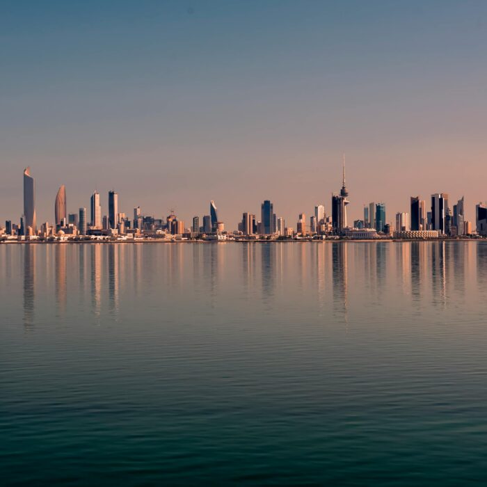
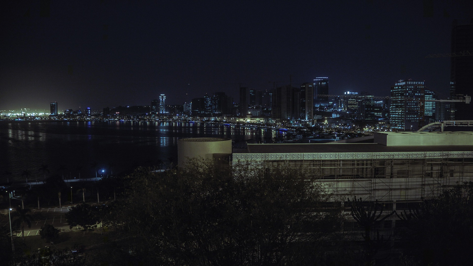
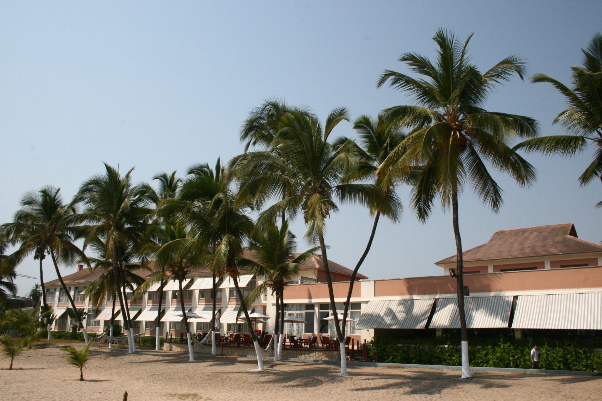
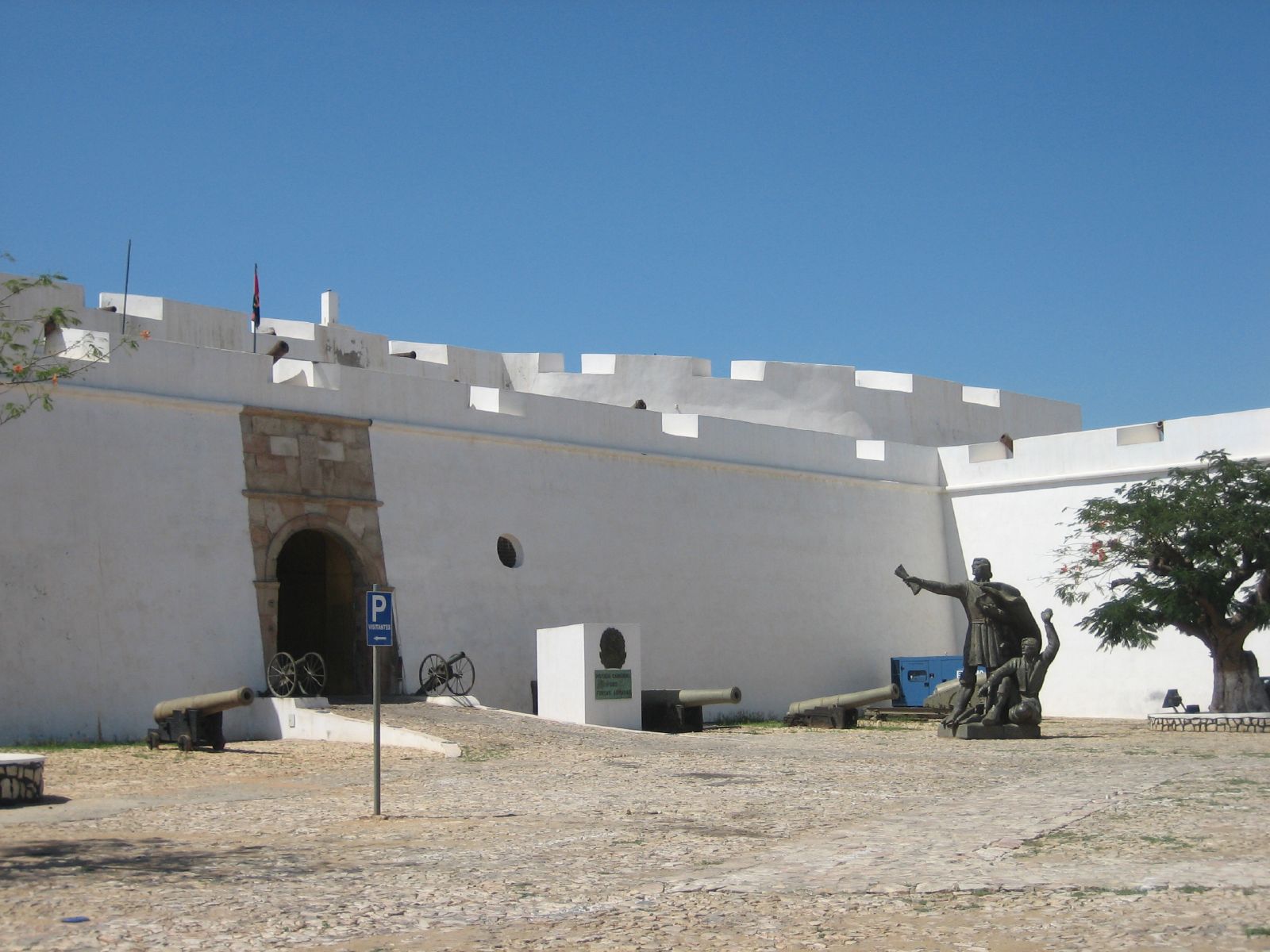
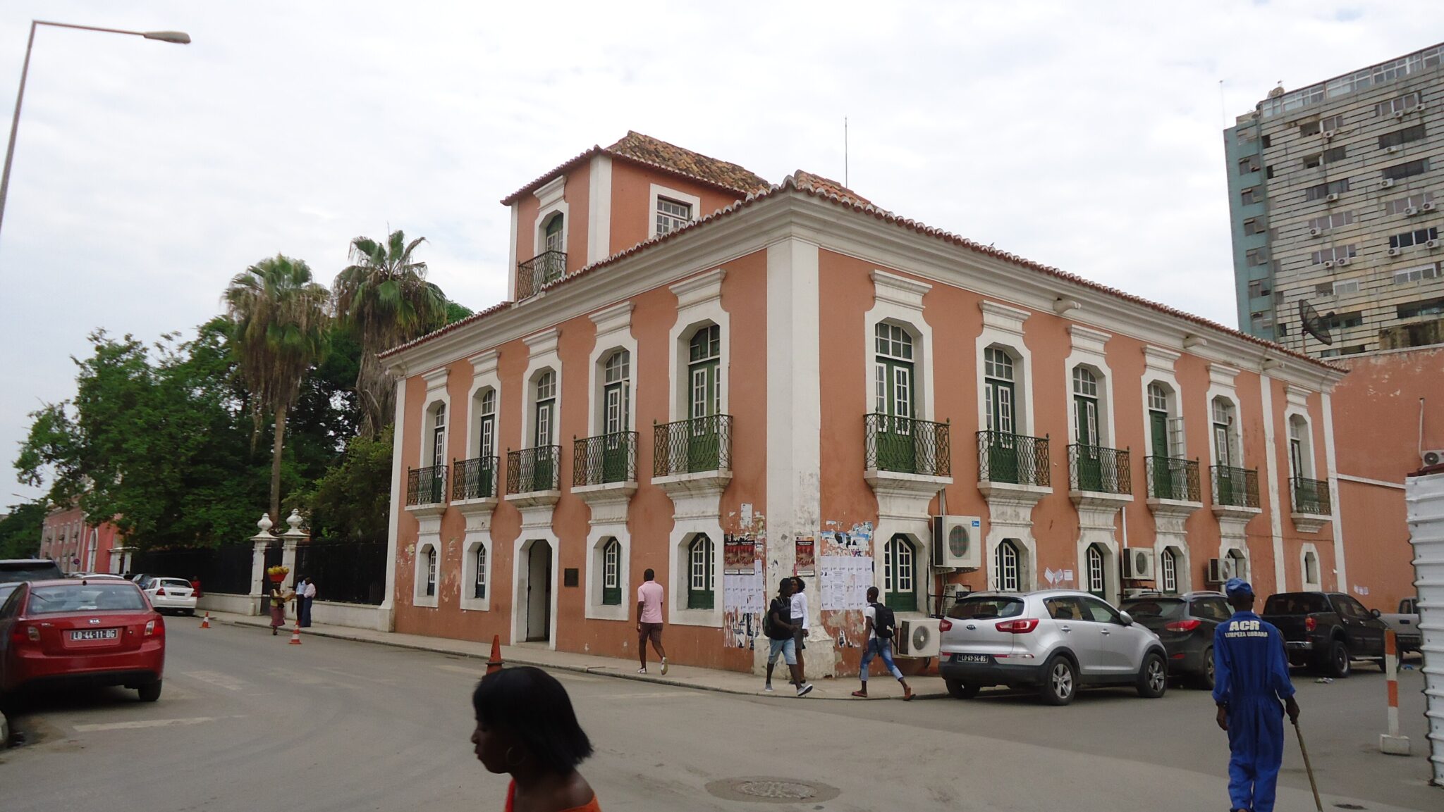
Luanda is Angola’s capital, primary seaport, and main business hub, founded in 1576 and now a mega-city of roughly 10.4 million people (2026 city figure), with a metropolitan population commonly placed above 11 million and a municipal area of about 1,645 km². The city’s most distinctive urban scene is Luanda Bay, where you can see the working side of a coastal capital: small boats, informal trade, and heavy traffic moving goods between port districts and inner neighborhoods. For history and views, Fortaleza de São Miguel is the key landmark. Built in 1576 on high ground above the bay, it offers one of the best panoramic lookouts over the waterfront and today functions as a military history museum. For cultural context, the National Museum of Anthropology is a strong stop: founded in 1976, it is organized across 14 rooms and holds more than 6,000 objects, including masks, musical instruments, tools, and ethnographic material that help you interpret traditions from different Angolan regions. For an easy coastal break, the Ilha do Cabo area, a narrow coastal strip about 7 km long, is the city’s most popular leisure zone for beach walks, restaurants, and sunset views.
Luanda works best as a logistics base because time and mobility matter here. Traffic is often heavy, so even short distances can take 30 to 60 minutes at peak hours; grouping nearby stops on the same day is the simplest way to keep the schedule realistic. International access is in transition: the newer Dr. António Agostinho Neto International Airport (NBJ) is about 40 to 50 km from the city and has long runways (up to 4,000 m), while the older Quatro de Fevereiro Airport (LAD) is much closer to central Luanda at roughly 5 km. In practice, plan your airport-to-city transfer as 40 to 60 minutes from NBJ in normal conditions (longer with traffic), and 15 to 30 minutes from LAD. Inside the city, the fort, central museums, and the bayfront are typically a 10 to 20 minute taxi ride from downtown hotels, while Ilha do Cabo is also a short drive, but can slow down significantly around evening dining hours.
Benguela
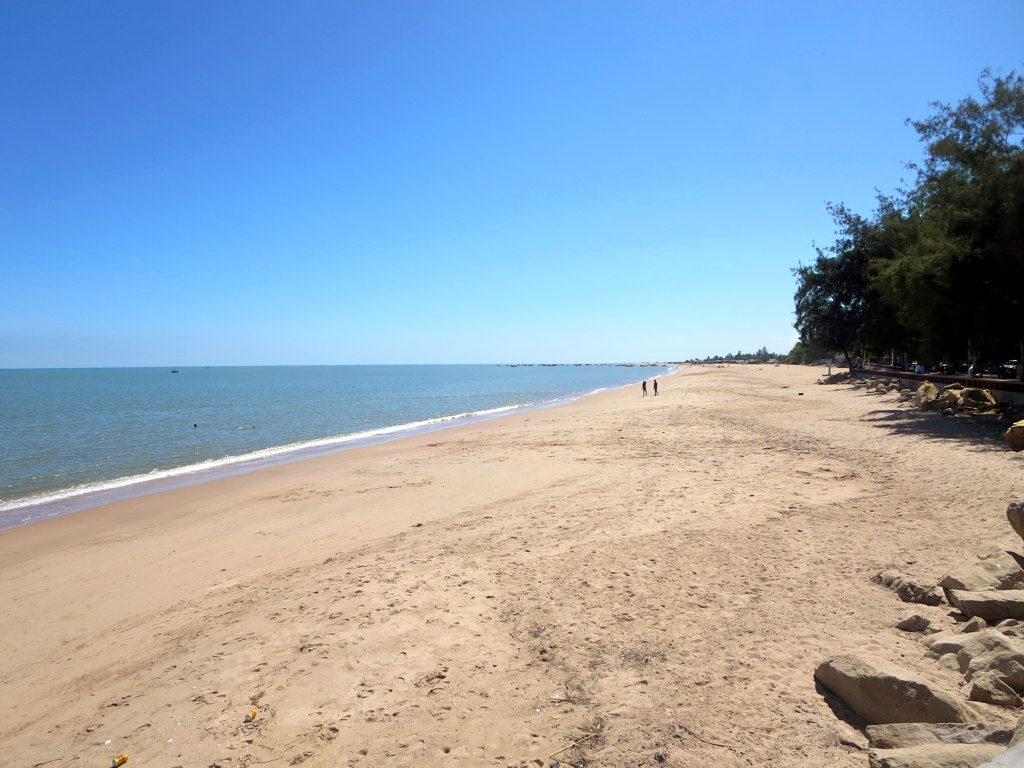
Benguela is one of Angola’s classic coastal cities, founded in 1617, with a calmer pace than Luanda and a strong sense of place built around its seafront and older urban fabric. The city’s appeal is spread across its atmosphere rather than a single monument: you can spend an hour simply walking the historic core to spot Portuguese-era facades, small squares, and everyday street life, then shift to the waterfront in the late afternoon when the city comes alive for ocean views and evening air. Benguela also works well as a base for nearby coastal scenery. The closest “easy” beach area is typically Baía Azul, a well-known stretch of sand and rocky shoreline used for quick escapes and sunset time, while longer beach days are often done by heading toward Lobito, whose coastal strip and bay sit immediately to the north.
Getting there is straightforward, and Benguela is usually paired with Lobito as a single coastal hub. The quickest approach is to fly into Catumbela Airport (CBT), which serves both Benguela and Lobito; from the airport, Benguela is commonly around 15 to 25 km away, often 20 to 40 minutes by car depending on traffic and where you are staying. Overland from Luanda, the drive is roughly 550 to 600 km depending on the route, and many itineraries plan 7 to 10 hours with stops. A practical rhythm is to use Benguela as a “reset” point: organize coastal day trips that keep driving short, reserve longer inland detours for a separate day, and build extra buffer time for road conditions and city traffic when you connect onward.
Lobito
Lobito is a port city on Angola’s central coast, immediately adjacent to Benguela, and it functions as a practical hub because the port and rail connections tie the coastline to the interior. The city is closely associated with the Benguela Railway corridor, historically built to move freight between the Atlantic and inland Angola, which is why you will notice a “working” rhythm around transport, warehouses, and port-related activity. For visitors, the most enjoyable time is usually along the water: the bayfront areas and long coastal sands make for easy walks, sea views, and an unforced look at everyday life in a coastal trading city. It is the kind of place where a short stay becomes more rewarding if you treat it as a coastal pause, combining a simple waterfront evening with a morning beach walk before you continue your route.
Getting to Lobito is simple from the main regional gateways. If you fly into Catumbela Airport (CBT), which serves both Benguela and Lobito, plan roughly 20 to 35 km to Lobito, commonly 30 to 60 minutes by car depending on traffic and the district. By road, Lobito is effectively part of the Benguela-Lobito urban area, so transfers between the two cities are short and often done in 15 to 30 minutes. From Luanda, the drive is typically in the 550 to 600 km range depending on your route, and many itineraries treat it as a full day on the road with stops.
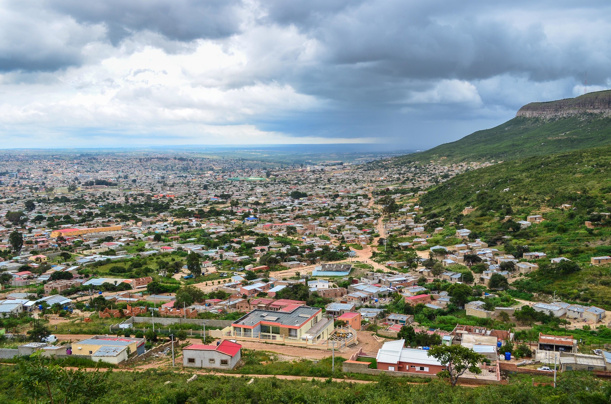
Lubango
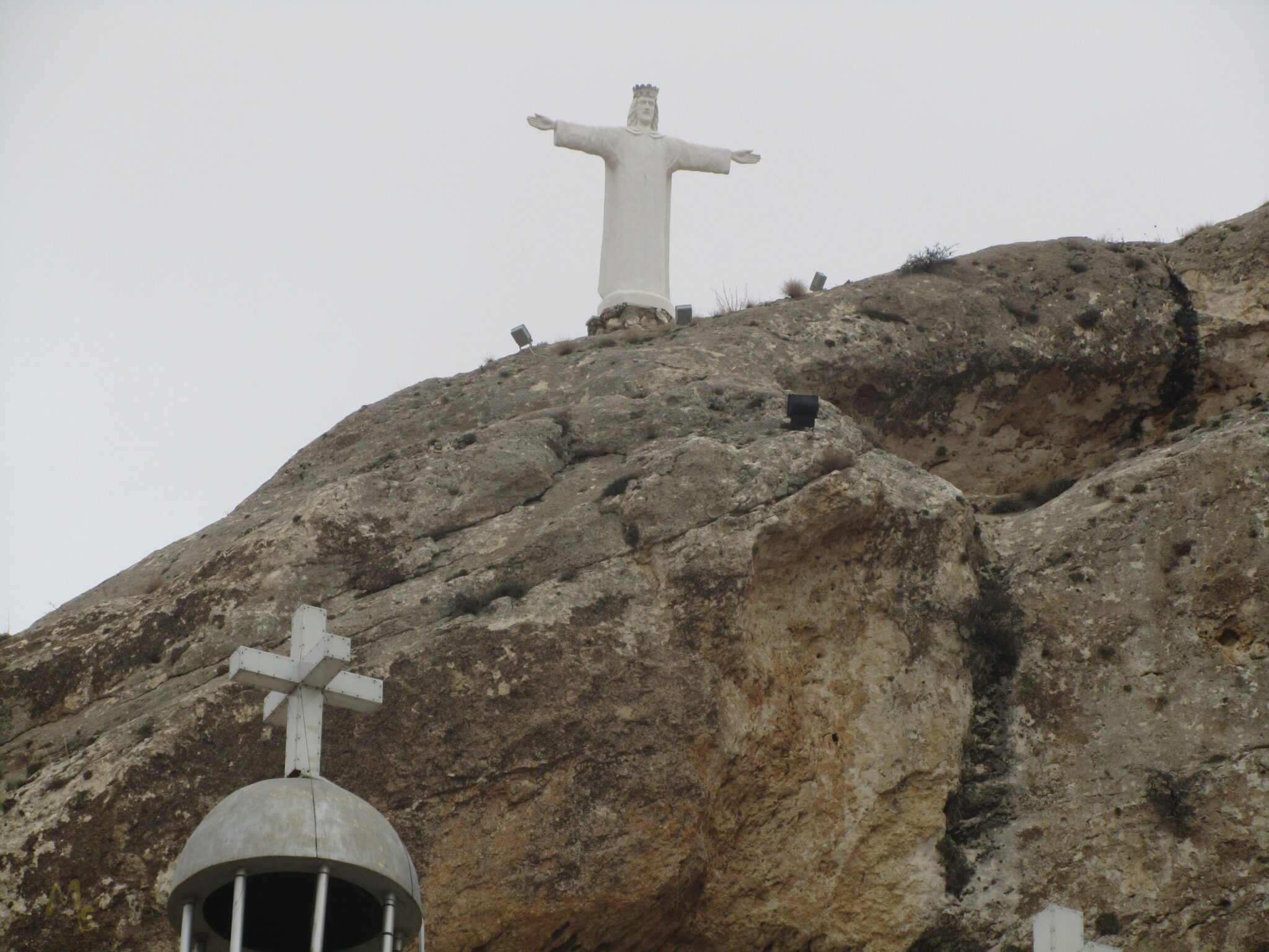
Lubango is the main city of Angola’s southern highlands and a noticeably cooler base than the coast, sitting at around 1,720 m above sea level with a mild highland climate where the annual average temperature is about 18.6°C and cold nights are common in the dry season. It is the best hub for Angola’s most famous escarpment scenery: the Serra da Leba Pass delivers the country’s iconic switchback road and dramatic altitude change, climbing roughly 1,845 m in about 30 km, with short sections that can reach gradients near 34 percent. For viewpoints, the Tundavala escarpment is the headline stop, with a rim exceeding 2,200 m and a drop of roughly 1,000 m to the plains below, plus wide-open views that can extend across an enormous area on clear mornings. In the city itself, the Cristo Rei (Christ the King) monument is the best-known landmark, a roughly 30 m statue on a hilltop with broad panoramas over Lubango and the plateau.
Lubango also works well for shorter nature outings that do not require heavy logistics. Cascata da Huíla is a convenient waterfall stop about 20 km from the city, and it is often paired with plateau drives and small rural detours for a full half-day. The city is served by Lubango Mukanka Airport (SDD) with a long asphalt runway of about 3,150 m, making it one of the most practical entry points for this region. Overland, Lubango connects directly to the coast via the Lubango to Namibe corridor, roughly 160 km to the west, with the Serra da Leba Pass as the memorable section of the drive.
Best Natural Wonders Sites
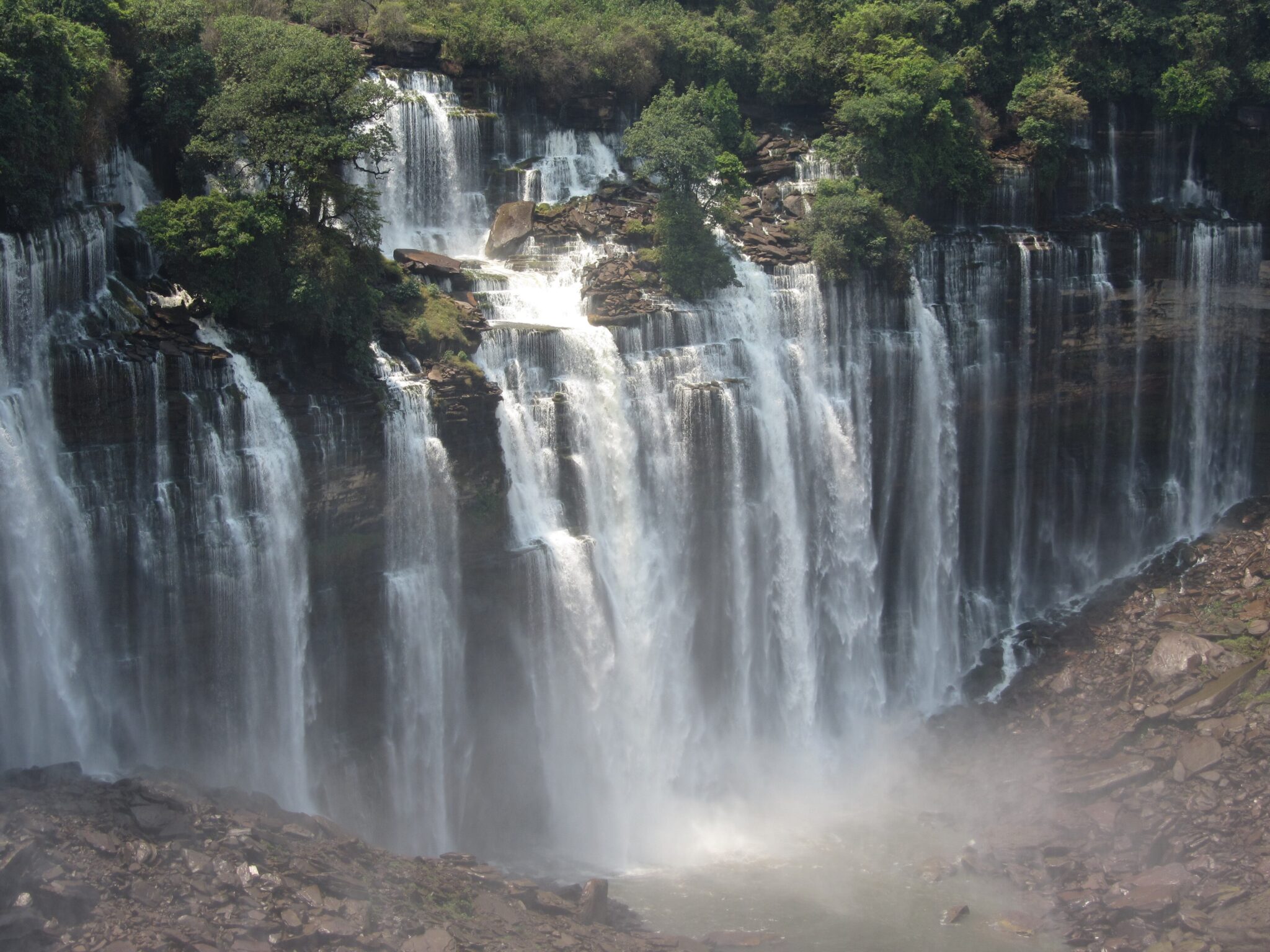
Kalandula Falls
Kalandula Falls, in Malanje Province, are one of Angola’s most powerful waterfall sights and are often described as among Africa’s largest by water volume. The main drop is commonly given at around 105 m, and the falls spread wide across the Lucala River, creating heavy spray and a constant roar at peak flow. The experience is viewpoint-based rather than trek-based: you can get dramatic panoramas from the rim, then follow short paths to lower angles where the scale becomes clearer. Season matters. In the wetter months the flow is at its most forceful and the spray can be intense, while in drier periods visibility tends to be cleaner and footing can be easier, even though the water volume is lower.
Most travelers visit Kalandula Falls as a day trip from Malanje city, which is the practical base for the area. By road, Malanje to Kalandula is commonly around 80 to 90 km, often about 1.5 to 2.5 hours depending on road condition and stops. From Luanda, many itineraries route via Malanje, with the Luanda–Malanje drive typically in the 380 to 420 km range, often 5 to 7 hours in good conditions, then continue to the falls the same day only if you start early. If you are short on time, the simplest plan is an overnight in Malanje: it allows an early morning start, better light for photos, and more flexibility if rain or spray limits viewpoints. Bring waterproof protection for electronics and shoes with grip, as the ground near viewing areas can be slick, especially during high flow.
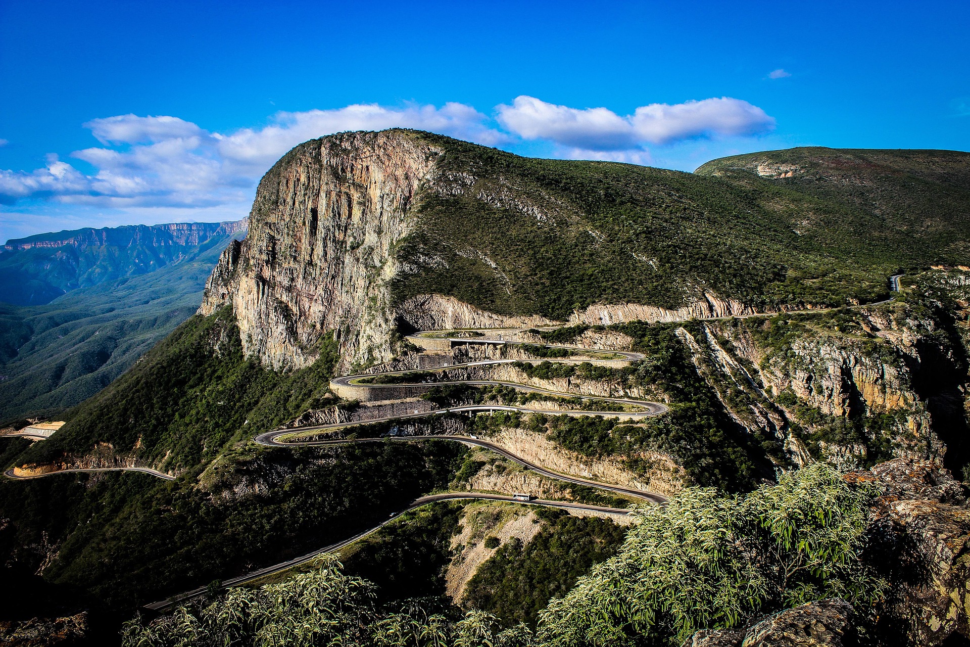
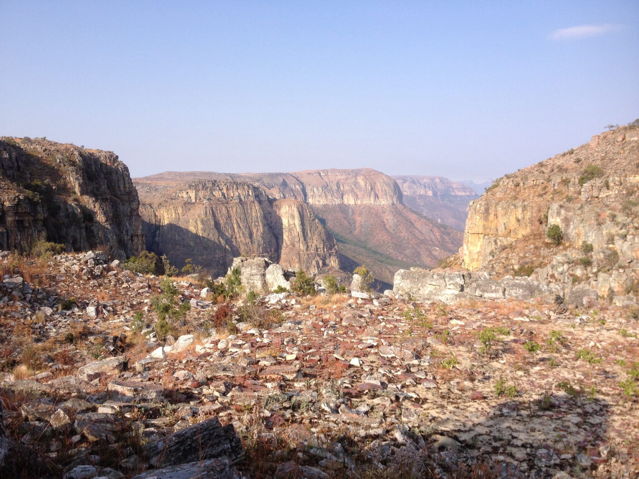
Serra da Leba Pass
Serra da Leba Pass is Angola’s signature escarpment road, best known for its tight switchbacks and sweeping views where the highland plateau drops toward the coastal plain. The route is part of the classic Lubango to Namibe corridor and the scenery is the main attraction: dramatic bends stacked on a steep slope, wide horizons when the air is clear, and a strong sense of scale as you look down across the plains. The elevation change is substantial, with figures commonly cited at roughly 1,845 m over about 30 km, and some short sections can reach gradients close to 34 percent, which explains why the bends are so sharply engineered. The most rewarding way to “visit” is to stop at pull-offs above and below the switchbacks for photos, then do a slow, scenic drive rather than treating it as a fast transit segment.
Most travelers experience Serra da Leba as a half-day outing from Lubango or as a highlight on the drive to Namibe. From Lubango, the key viewpoints are typically reached in about 30 to 60 minutes by car depending on where you stop, while continuing all the way to Namibe is roughly 160 km and often around 2.5 to 4 hours in normal conditions. Timing matters: early morning tends to deliver clearer visibility and cleaner light, while late afternoon can create strong shadows that sculpt the terrain and make the switchbacks look more dramatic.
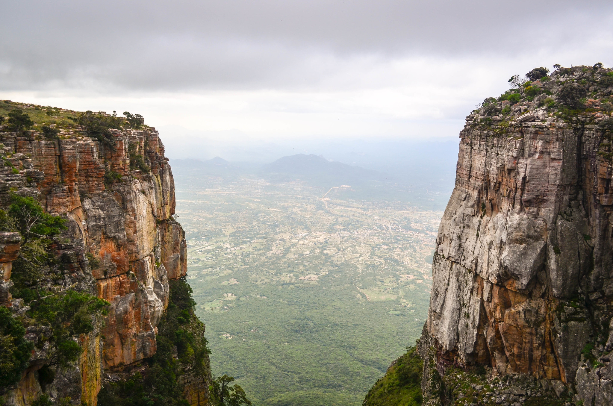
Tundavala Gap
Tundavala Gap is the signature viewpoint near Lubango, where the southern highlands end in a dramatic escarpment and the land falls away into vast plains. The draw is pure scale: you stand on the rim and get a wide, uninterrupted panorama that can feel almost endless on a clear morning, with layered ridges, deep drop-offs, and shifting light that makes the cliff line look sharper as the sun rises. It is minimally developed, which keeps the experience raw and photographic, and it works especially well if you arrive early, when haze is lower and visibility is usually at its best.
From Lubango, Tundavala is an easy half-day outing. Most visitors reach it by car in roughly 30 to 60 minutes depending on the exact access road and stops, then spend 45 to 90 minutes walking between viewpoints and taking photos. It pairs naturally with Serra da Leba on the same day if you start early: do Tundavala first for crisp morning views, then drive the pass later when shadows shape the switchbacks.
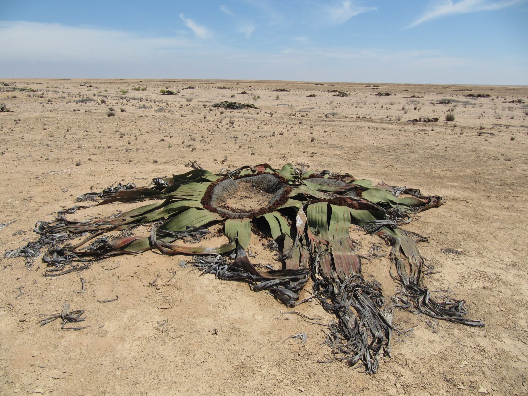
Namibe Desert (near Tombua)
The Namibe Desert near Tômbua is one of Angola’s most striking coastal landscapes, where ochre dunes and stony plains run straight into the Atlantic. What makes this desert special is its fog ecology: cool, moisture-bearing sea fog regularly rolls inland, allowing hardy plants to survive in extreme dryness, including the iconic Welwitschia mirabilis, a species found only in Angola and Namibia and known for individuals that can live for over 1,000 years. The best things to see are the dune fields and gravel plains at sunrise, the fog-softened coastline with fishing activity and wide beaches, and, with a guide, botanical zones where desert-adapted vegetation clings to life in wind-sculpted shapes.
Treat the area as a guided day trip or an overnight based in Namibe or Tômbua. From Namibe city to Tômbua it is about 95 to 100 km by road, usually around 1.5 to 2 hours depending on stops and road condition; from Lubango to Namibe it is roughly 160 to 180 km, typically 2.5 to 4 hours via the Serra da Leba corridor, then continue south to Tômbua the same day if you start early. For deeper desert routes, including entry zones toward Iona National Park, plan on a 4×4, extra fuel, and local logistics, as tracks can be sandy, signage is limited, and conditions shift quickly with wind and fog. Carry more water than you expect to need, start activities early, and protect yourself from both sun and wind, as the coast can feel cool while the interior heats up fast.
Best Beaches and Coastal Destinations
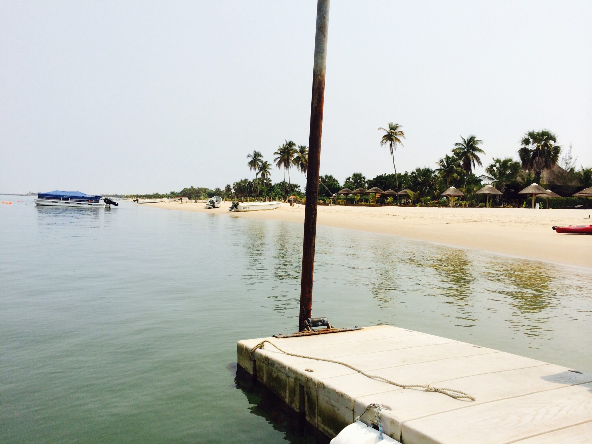
Ilha do Mussulo
Ilha do Mussulo is a long barrier island just south of Luanda that shelters a calm lagoon on one side and faces the open Atlantic on the other, which is why it is one of the easiest “beach reset” spots in Angola. The lagoon side is the main draw for travelers: gentler water, sandy shallows, and a relaxed strip of beach clubs and eco-lodges where you can do low-effort days of swimming, paddle outings, and sunset dinners. The atmosphere changes quickly with the calendar, as it is a classic weekend escape for Luanda residents, so weekdays feel noticeably quieter and more spacious.
Getting there is typically a short transfer from Luanda to a boat crossing point, followed by a brief ride over the lagoon to whichever lodge or beach area you are using. In normal conditions, plan roughly 30 to 60 minutes from central Luanda to the departure point by car, then about 10 to 25 minutes by boat, depending on sea state, tide, and where on Mussulo you are heading.
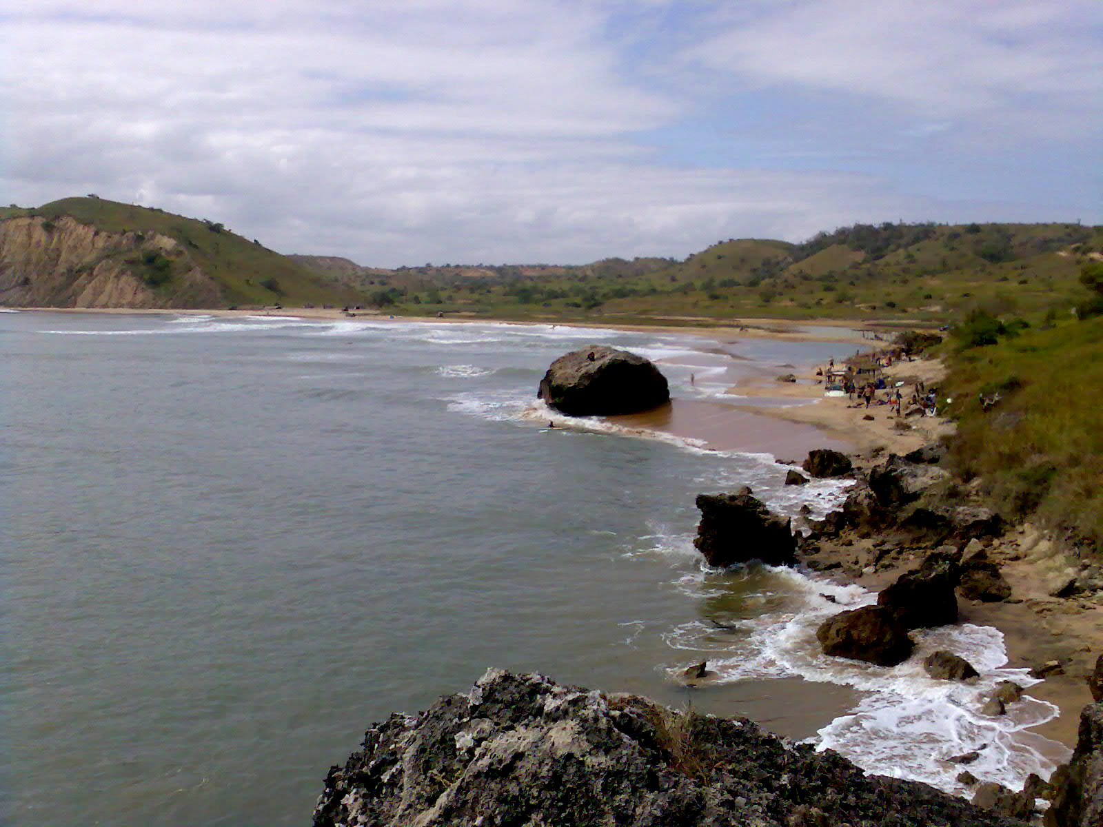
Cabo Ledo
Cabo Ledo is one of the best coastal breaks south of Luanda if you want a wide, open Atlantic beach with a more natural feel and fewer urban distractions. It is especially known for surfing thanks to consistent swell and long sandy stretches, and the scenery is defined by big horizons, coastal dunes, and a relaxed, low-rise shoreline rather than dense development. Even if you are not surfing, it works well for long beach walks, watching surfers and fishing activity, and catching late-afternoon light when the coast looks most dramatic.
From Luanda, Cabo Ledo is usually done as a day trip or an easy overnight. By road it is commonly around 120 to 140 km south of the city depending on your exact starting point, and the drive is often about 2 to 3 hours with traffic, checkpoints, and road conditions influencing the total time. Most travelers go by private car with a driver or a pre-arranged transfer, then spend several hours on the beach before returning to Luanda the same day.
Baía Azul (Benguela Province)
Baía Azul is one of the most scenic coastal stops in Benguela Province, known for its sheltered bay, clear water, and a calmer, more local atmosphere than the busier beach strips around the capital. The setting is ideal for a slower day: short coastal walks over rocky points, time on the sand with wide sea views, and relaxed swimming when conditions are calm. Because the bay is more about scenery and space than nightlife, it fits well into an itinerary based in Benguela or Lobito, especially if you want an easy reset day between longer drives. From Benguela, Baía Azul is typically reached by road as a straightforward half-day or full-day outing. Depending on your exact starting point and the access track you choose, plan roughly 30 to 60 minutes of driving, longer if you stop frequently for viewpoints along the coast.
Praia Morena (Benguela)
Praia Morena is Benguela’s main urban beach and promenade, a simple but enjoyable place to understand the city’s coastal rhythm. The beach itself is not about isolation, but about atmosphere: a long seafront walk, local families out in the evening, fishermen and small vendors, and restaurants and cafés where you can try grilled fish and other coastal staples. It works best as a low-effort stop after daytime excursions, when the light softens and the shoreline feels more social than touristic, with plenty of chances for people-watching and casual photos. Getting there is easy from anywhere in Benguela, usually a short taxi ride of about 5 to 15 minutes depending on where you are staying, and many visitors can reach it on foot from central accommodation. If you are based in Lobito, plan a quick transfer between the two cities, typically 15 to 30 minutes by car, then go straight to the promenade for late afternoon.
Best Cultural and Historical Sites
Fortaleza de São Miguel (Luanda)
Fortaleza de São Miguel is Luanda’s most important colonial-era landmark, founded in 1576 and built as the city’s main Portuguese defensive stronghold above Luanda Bay. The site is valuable for two reasons: context and viewpoint. It helps you place Luanda’s origins as an Atlantic port, and it also delivers one of the best panoramic looks over the bay, the waterfront, and the modern skyline. Inside the fort, expect a compact museum-style visit focused on military and colonial history, with displays that typically include cannons, uniforms, and curated objects that explain how the coastline was controlled and supplied over time.
National Museum of Anthropology (Luanda)
The National Museum of Anthropology in Luanda is one of the most useful early stops if you want to understand Angola beyond the capital. Founded in 1976, it is organized across 14 rooms and holds more than 6,000 objects, with a strong focus on ethnographic material such as masks, ritual items, textiles, tools, and musical instruments. The value is practical: it helps you recognize regional patterns in materials, symbols, and craftsmanship, so later visits to markets, villages, and cultural sites feel more legible. Plan about 1 to 2 hours for a focused visit, longer if you prefer to read labels and move slowly through the thematic rooms.
Christ the King Statue (Lubango)
Christ the King (Cristo Rei) in Lubango is the city’s best-known landmark, a hilltop monument that doubles as a practical viewpoint over the surrounding highland landscape. The stop is simple but worthwhile because it quickly orients you: you can see the city’s layout, the plateau’s open spaces, and the direction of the escarpment scenery you may be heading to next. It is also a calm place to pause after driving, with wide horizons that make Lubango’s cooler, more spacious feel very clear compared with the coast.
From central Lubango, the statue is typically reached by a short taxi or car ride of about 10 to 20 minutes, depending on where you start and how busy the roads are. Most visitors spend 30 to 60 minutes on site for photos and views, longer if you stay for changing light. Late afternoon is often best for softer light and cooler temperatures, while mornings can deliver clearer skies and sharper visibility, especially if haze tends to build later in the day.
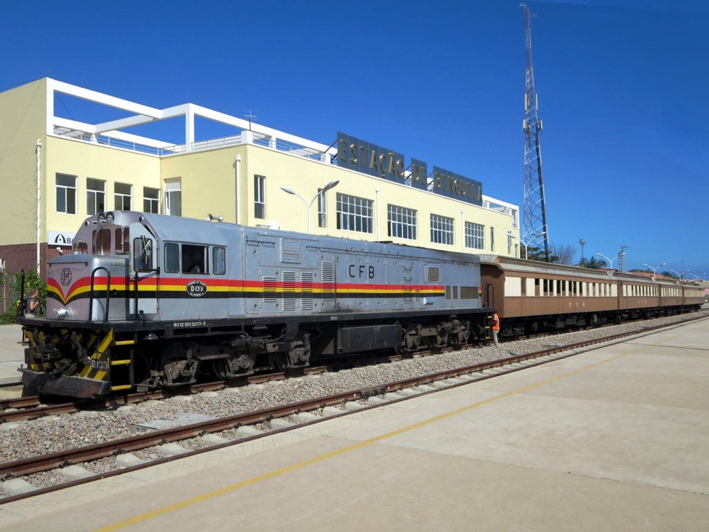
Benguela Railway Stations (Historic Sections)
Historic sections of the Benguela Railway (Caminho de Ferro de Benguela, CFB) are best treated as “context stops” that explain why Lobito and Benguela matter in Angola’s geography. The railway was designed to link the Port of Lobito to the interior and ultimately to the far eastern border at Luau, creating a coast-to-interior corridor of roughly 1,300 km (commonly cited around 1,344 km). Built mainly in the early 20th century and completed to the eastern end in 1929, it became one of the most important export routes for inland minerals and agricultural goods, and many stations still reflect that era through their proportions, platforms, track yards, and warehouse zones. What to look for on a short visit is the “railway landscape” rather than a single exhibit: station façades, old signage or metalwork where preserved, platform geometry, adjacent freight areas, and the way today’s city streets wrap around historic transport infrastructure.
Hidden Gems of Angola
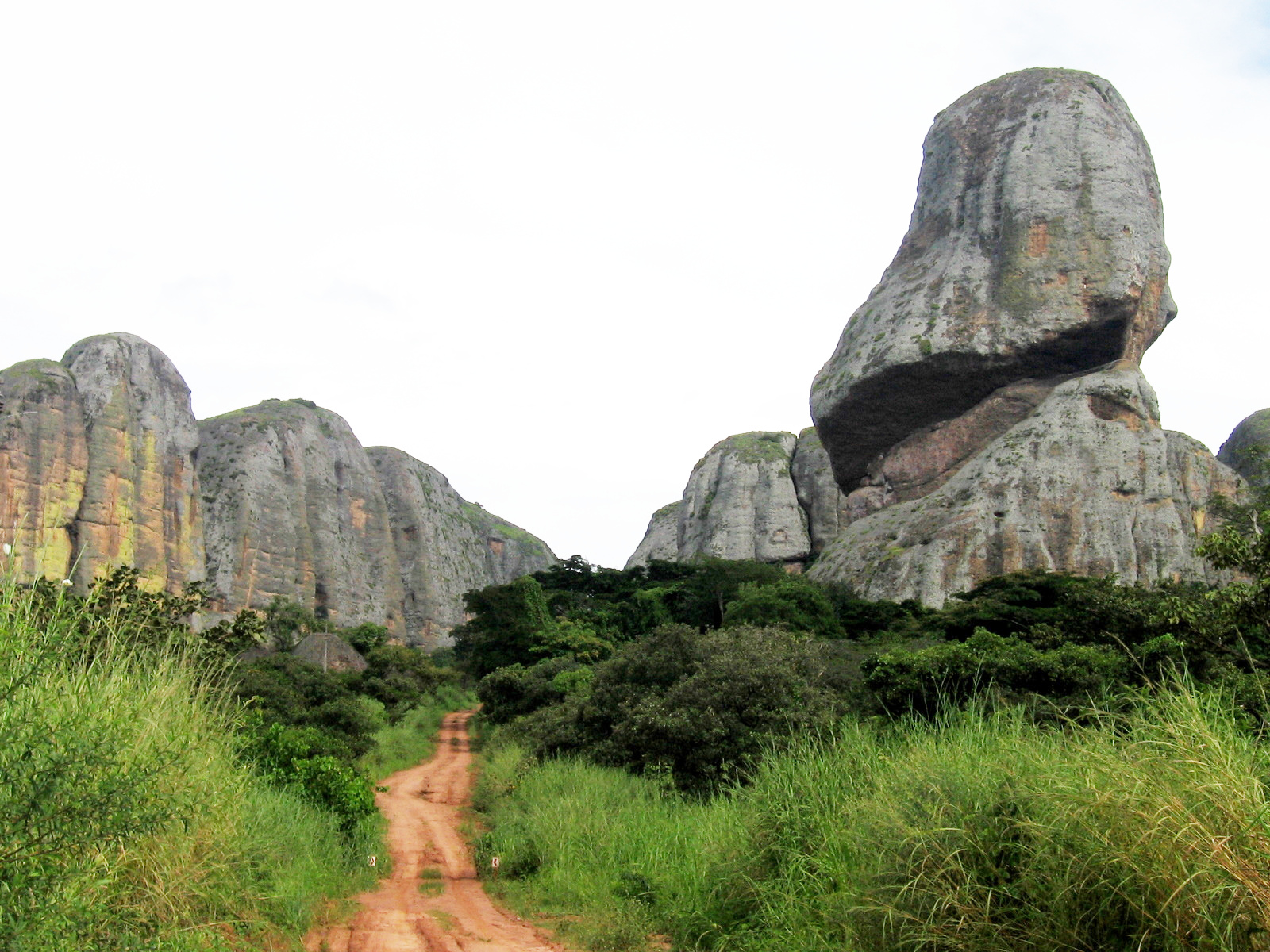
Pedras Negras de Pungo Andongo
Pedras Negras de Pungo Andongo are a dramatic cluster of dark, tower-like rock pinnacles rising roughly 150 to 200 m above the surrounding savannah and spread across an area often described at about 50 km². Geologically, they are millions of years old and stand out because the landscape around them is comparatively flat, so the silhouettes look almost “impossible” at sunrise and late afternoon when shadows carve the shapes into sharp relief. Beyond scenery, the site carries cultural weight: local tradition links the rocks to the era of pre-colonial kingdoms in the region and to stories associated with Queen Nzinga, which is why many visitors treat the stop as both a natural landmark and a historical reference point rather than only a photo location.
Most visits are done as a day trip by road from Malanje city, with the rocks commonly placed around 115 to 116 km away, typically about 2 to 3 hours by car depending on road condition and stops for viewpoints. From Luanda, the practical approach is to base yourself in Malanje first: Luanda to Malanje is roughly 380 to 390 km by road, often 5.5 to 7 hours in real conditions, then continue to Pungo Andongo the next morning for the best light.
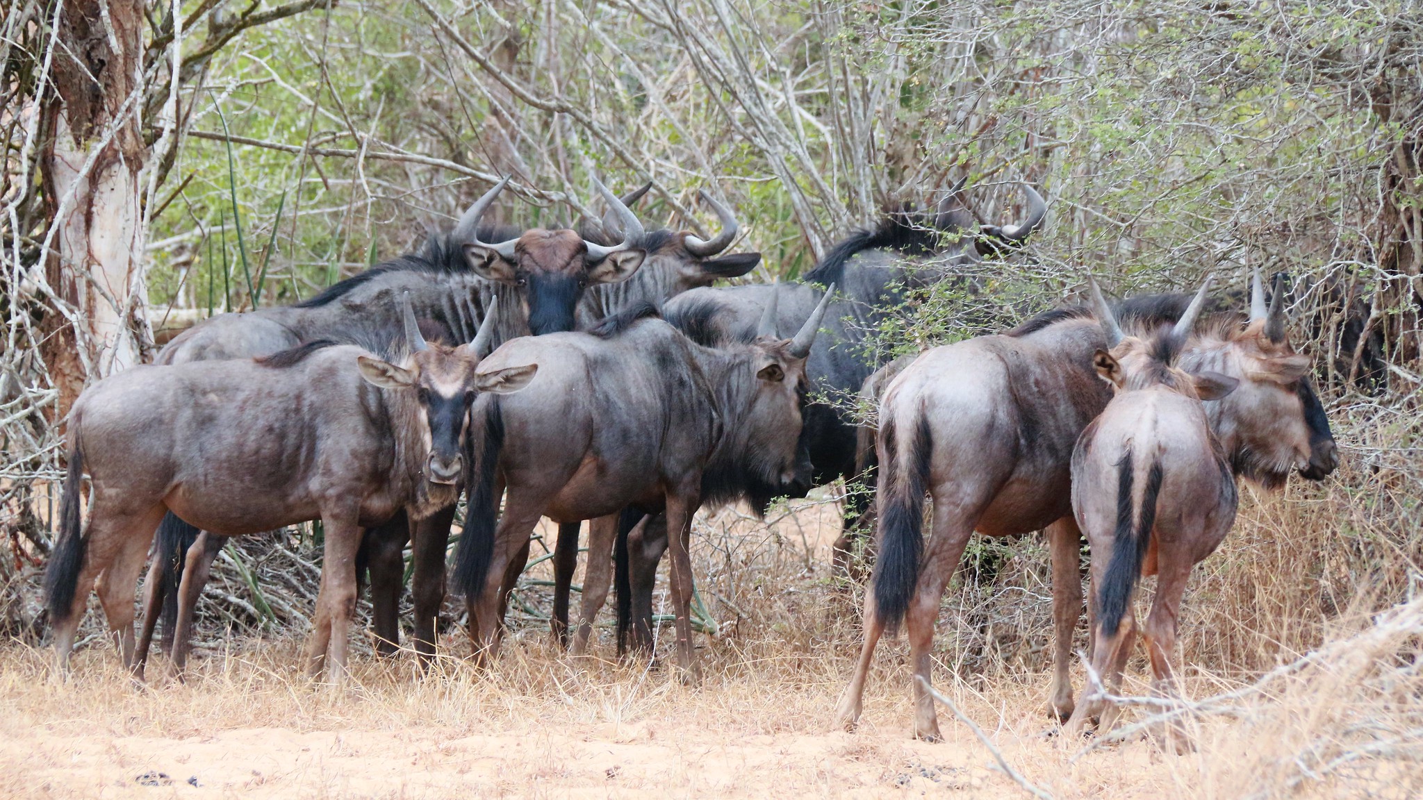
Kissama (Quiçama) National Park
Kissama (Quiçama) National Park is Angola’s most accessible protected area from Luanda, combining savannah, woodland, and riverine zones where the Kwanza River meets the Atlantic. It is known for wildlife reintroduction efforts, so the experience is more about a developing nature reserve than a “guaranteed big-five” safari. When conditions and guiding are good, visitors may see species such as giraffes, zebras, antelope, and other plains animals, with birdlife often being the most consistent highlight across seasons, especially near wetlands and river edges. The best way to enjoy the park is to treat it as a landscape day: long, slow drives with frequent stops for scanning, plus short walks only where guides consider it appropriate and safe.
From Luanda, Kissama is typically visited as a full-day trip. The main access is south via the coastal corridor and the park gate area, commonly around 70 to 100 km from the city depending on your starting point and the entry zone you use, with driving time often 2 to 3 hours each way once traffic and road conditions are factored in.
Fenda da Tundavala (Alternate Viewpoints)
Fenda da Tundavala refers to alternative viewpoints and quieter angles along the same escarpment system as the main Tundavala “big view” stop near Lubango. The appeal is a more remote feel: fewer people, wider freedom to choose your own framing, and the chance to see different cliff shapes, fissures, and ledges where the plateau breaks toward the plains. These lesser-used perspectives often deliver stronger atmosphere than the main viewpoint because you can hear the wind, watch clouds forming along the rim, and photograph the escarpment without crowds. The best time is early morning for clear visibility, or late afternoon when shadows deepen the relief and the rock faces look more sculpted.
Iona National Park
Iona National Park is Angola’s largest protected area, covering roughly 15,150 km² in the far southwest, where the Namib Desert transitions into rugged hills and isolated mountain massifs. What makes Iona special is the variety in a single, stark landscape: Atlantic-influenced coastal desert (often with fog), gravel plains and dunes, dry riverbeds that briefly run after rains, and rocky escarpments with wide, empty horizons. Sightseeing here is landscape-driven rather than checklist-based: long 4×4 drives to viewpoints, short hikes to rock formations and dry valleys, and guided searches for desert-adapted plant life such as Welwitschia, plus the chance of spotting wildlife that uses ephemeral water sources and coastal fog corridors. Because the park is lightly developed, the “experience” is the feeling of scale and isolation, with minimal crowds and very limited services.
Travel Tips for Angola
Safety and General Advice
Travel conditions in Angola vary considerably by region. The capital, Luanda, and other major cities are generally safe for travelers who take normal precautions, while remote or rural areas require more careful planning. It is advisable to stay updated on current travel advisories, particularly for journeys outside the main urban and coastal zones. Local guidance and reliable transportation arrangements are essential for safe and efficient travel, as infrastructure remains limited in some regions.
A yellow fever vaccination is required for entry into Angola, and malaria prophylaxis is strongly recommended due to the high prevalence of mosquito-borne diseases. Tap water is not safe to drink, so rely on bottled or filtered water. While medical facilities in Luanda are of reasonable quality, services outside major cities can be basic or difficult to access. Comprehensive travel insurance that includes evacuation coverage is highly recommended for all visitors.
Car Rental and Driving
An International Driving Permit is required alongside your national driver’s license, and all documents should be carried at checkpoints, which are common throughout the country. Driving in Angola is on the right-hand side of the road. While roads in and around Luanda and major coastal corridors are paved and in fair condition, many rural roads remain unpaved or uneven, especially after rain. A 4×4 vehicle is strongly recommended for long-distance or off-road travel. Because of challenging conditions, hiring a driver is often more practical and safer than self-driving.
Published January 23, 2026 • 20m to read